
Passwang
| Passwang | |||
|---|---|---|---|
 Passwang south side near Mümliswil-Ramiswil |
|||
| Compass direction | west | Southeast | |
| Pass height | 943 m above sea level M. | ||
| Canton | Solothurn | ||
| Valley locations | Erschwil | Mümliswil | |
| expansion | Pass road (peak tunnel) | ||
| Built | 1729–1732 (old street), 1931–1933 (new street) | ||
| profile | |||
| Ø pitch | 4.5% (490 m / 11 km) | 5.4% (386 m / 7.1 km) | |
| Max. Incline | 11% | 11% | |
| Map (Solothurn) | |||
|
|||
| Coordinates | 616431 / 245299 | ||

The Passwang , formerly also Barschwang ( Solothurn German Ba (r) schwang [ baʳʃˈvaŋ ], [ baʃˈvaŋ ]), is a mountain ridge in the municipality of Mümliswil-Ramiswil in the Solothurn Jura , Switzerland . The main peak of the ridge is the Vogelberg, 1204 m above sea level. M. The Passwang borders in the northwest and north on the Solothurn community of Beinwil and on Lauwil in the canton of Basel-Landschaft . The mountain pass of the same name leads over the Passwang with a road that has a pass height of 943 m above sea level. M. connects the southern parts of the canton of Solothurn with the Schwarzbubenland via Mümliswil and Beinwil . Today's pass is in a short tunnel. About 700 meters east of the northern tunnel portal is the Passwanghöhe ( 992 m above sea level ) and another 150 meters east of the Mittler Passwang , at 1001 m above sea level. M. the natural and historical pass over the ridge. The Passwang is also considered a lookout point .
Surname
The name is first attested around 1480 as boswand and boschwand , later among other things as Porschwand (first 1521), Baschwang (first 1582), Barschwang (first 1716). The Geographical Lexicon of Switzerland still has its article on Passwang (1905) under the Lemma Passwang or Barschwang . The name researcher Rolf Max Kully suspects an original name form * borswand meaning «clearing on the hill», from Old High German bor «hill» and swand « Schwende , clearing». The name is related to that of the Born mountain near Olten . Kully rejects the older interpretation as «bare», bald Schwende. Kully's interpretation was adopted from the Solothurn name book in 2010 . The folk etymological reinterpretation of “Pass bei der Felswand” (dialect pronunciation: Wang ) in view of the steep rock face near the top of the pass was rejected as early as 1928 in an article by the Basel secondary school teacher A. Seiler ; later authors have joined him. The dialectal pronunciation Barschwang has in the field names Mittleri and Oberi Barschwangweid received.
geography
Location and landscape

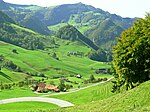
The Passwang chain in the broadest sense extends over a length of around 22 kilometers between Mont Raimeux on the canton border Bern / Jura and the Upper Hauenstein south of the Waldenburg valley in the canton of Basel-Landschaft . It reaches its highest elevations at 1204 m above sea level. M. each in the canton of Solothurn on the Hohe Winde and on Vogelberg. To the north and south, the area is flanked by other more or less pronounced chains.
The Passwangstrasse between Beinwil and Mümliswil is the only road crossing that connects the northern ( Schwarzbubenland ) and southern parts of the canton of Solothurn. It is a diagonal pass that crosses the mountain ridge at an angle and not, as usual, orthogonally. The passport term as such is only partially applicable. The natural conditions are rather unfavorable for road construction due to the tectonically complex area. In addition, the Passwang lacks a well-defined transition point that is visible from the valleys.
A topographical and morphological peculiarity of the Passwangstrasse is near Neuhüsli below the north ramp, where a landslide in 1598 dammed a lake. The siltation level of the watercourse, which was drained in the 18th century, is still partially visible today, the road is led past it over an artificial dam, called Schanz .
Geology and geomorphology

The Passwang area is part of the Kettenjura and is characterized by a very confusing chain and fold course . More recent disturbances, which resulted from the unfolding of the Kettenjura, blended with older disturbances, which go back to the sinking of the Rhine valley trench. Horizontal thrust sheared off the sediment cover on the salt and gypsum clays of the middle Muschelkalk and formed folds. The great flexure of the Rhine valley caused a stiffening. As a visible consequence of these processes, a large number of short chains (brachy anticlinals ) exist in this area . As the chains are pushed further east of the stiffened flexure, the folds often tear open and transverse fractures occur, which usually appear as transverse displacements.
The core of the Passwang chain consists of the Brown Jura , which was pushed over a length of twelve kilometers to the north and partially torn open. The tectonics are determined by two large transverse fractures in the area between the Scheltenpass and Nunningen . A secondary, overlying fold to the north occurs at the high winds. The south side of the Passwang chain is steep between Scheltenpass and Passwang, but without complications. From the summit tunnel of the pass road (Zingelentunnel) eastwards the massif begins to overturn and is torn apart by various disturbances. The resulting gap was used for the construction of the Passwangstrasse. The Zingelen tunnel, for example, shows the complex geological structure of the chain: At the north portal, the southern part of the Braunjura rises almost vertically and tips over on the smooth Fluh . Up to the middle of the tunnel follows a package of corrugated to approximately horizontal layers of the upper Braunjura. On Südportal the tunnel extends at an uphill incident , rugged and broken Sackungskomplex the upper Hauptrogenstein stone .
At Limmern, north of Mümliswil, on the south-eastern slope of the Vogelberg, there is the Swiss geotope no. 116. These are well-preserved stromatolites from the Lias period with an age of 177 million years. A high scientific value is ascribed to these algae-like structures, although they cannot be clearly interpreted ecologically. Algae and fungi as well as bacteria can be considered as producers. The outcrop is part of one of the few complete Lias profiles ( Rhät to Opalinus Clay ) of the Jura folds.
The Belchen- Passwang area is registered with the number 1012 in the federal inventory of landscapes and natural monuments of national importance . This is justified , among other things, with the largely intact and typical landscape of the Eastern Folded Jura and the large geomorphological treasure trove.
Passwangstrasse
history

The original route over the Passwang has been used as a "public road" since the Middle Ages. Evidence such as a discovery of Roman coins in Erschwil on Passwangstrasse suggest that the crossing was already used in Roman times, but clarity in this regard, according to Max Banholzer in 1975, cannot be gained. The south-facing part of the path was east of today's road. There were significant inclines on both sides and the pass was difficult to negotiate until the 18th century. It had a certain importance for the canton of Solothurn , since it had acquired the areas known today as Schwarzbubenland in the 15th and 16th centuries , as a connection to the southern part of the canton and the capital Solothurn , but the two served for trade between Basel and Solothurn Hauenstein passes . In order to avoid expensive Basel tariffs on salt obtained from Lorraine , Solothurn sought at the beginning of the 18th century to import this from Alsace via the territory of the prince-bishopric . For this purpose, the Passwangstrasse was expanded from 1729 to 1732. The street still had a bad reputation; so wrote Urs Peter Strohmeier in his description of the canton of Solothurn in 1836:
«The road over this mountain was built in 1730 by the builder Suri; it rises in many places over 20 feet per cent, and is indisputably the worst communication route in Switzerland, although it connects one of the most populous offices and the most extensive with the four other and the capital of the canton. It seems that when this breakneck road was built, the highest yokes and the most improper places were deliberately chosen to go through. "
Among other things, due to countermeasures in Basel (improvement of the road over the Obere Hauenstein , tariff reductions), but also because of the steep inclines and the Allschwil - Reinach connection , which was not established as agreed by the prince-bishop's government , the Passwangstrasse did not achieve the importance that the canton of Solothurn had had intended back then.
1852 ranged 18 municipalities from the Schwarzbubenland and four municipalities from the former district Balsthal-Thal in the Solothurn cantonal parliament a petition one, the Government is to commission, "to order the correction of Paßwangstraße, with observance of the shortest line and the least possible slope". The petition was declared substantial and in May 1853 the government submitted plans for a new road with a base tunnel of around 550 meters through the Barrenfluh to the Cantonal Council . In December 1853, however, the Cantonal Council decided not to pursue this project. The reasons for this were the high costs and the promising development of rail traffic in Switzerland.
From 1921 to 1923, a north-facing section in the Lüssel valley to Unterbeinwil was corrected by moving the road south of Erschwil to the right bank of the Lüssel. In 1925, the then National Councilor Hermann Obrecht and Josef Borer, President of the Swiss Isola-Werke in Breitenbach (today Von Roll ) campaigned for the construction of a Passwangstrasse road suitable for motor traffic. Various projects were discussed in the following years. Peter R. Huber wrote in his paper from 2012: "All participants in the discussion, be it private individuals, government and cantonal councils, municipalities and initiative committees, supported the expansion of the pass road, but everyone had a different opinion on how this should be done." The following suggestions were examined:

- Improvement of the existing road.
- A 700 m long base tunnel through the Krattenberg under the Barrenfluh, which is part of the Sonnenberg, which separates the Guldental from Beinwil.
- "Construction project 1928": A new road running roughly parallel to the old Passwangstrasse on the south side with a bridge over the Tümmelbach and a tunnel through the Glatte Fluh rock face at the Zingelen elevation with a length of 175 m.
- “Interim project”: Also with the Zingelen tunnel, but a new route that branches off the Scheltenpass road at Ramiswil via Hagli and Hagliberg .
An expert opinion recommended the "interim project" in April 1930 "as by far the most rational". This was subsequently approved by the Cantonal Council. By not classifying the project as a new road construction, but budgeting it as part of the cantonal expansion program, a referendum could be avoided. It was built from 1931 to 1933.
At the time of the global economic crisis , there was also high unemployment in the canton of Solothurn . The expansion of Passwangstrasse could serve as a job creation measure and the contractors had to employ unemployed people who were assigned to them by the cantonal employment office. The initiative for building the road did not go back to this, however, and according to Peter R. Huber, the project was “not part of a formulated overall project to combat unemployment and its consequences”. The working conditions when building roads and tunnels were tough. The Social Democratic Cantonal Councilor Adolf Heri complained about deficiencies after an unannounced visit to the construction site, including poor food and low wages. The Solothurn cantonal government partially recognized this and promised a remedy.
Projects to build a Passwang base tunnel were still under discussion until the late 20th century. A project draft from 1976 envisaged a 1200 m long base tunnel. In the structure plan of the canton of Solothurn 1997 this option was waived due to the low volume of traffic. A failed railway project in the Passwang area was the Wasserfallenbahn , which would have connected Reigoldswil in the canton of Basel-Landschaft to Mümliswil with a tunnel . The construction work that had already started was stopped again after a short time in 1874.
Extensive renovation work on the tunnel and on the south side took place in 1997. Since 2016, the north side has also been renovated. The entire renovation, which is to last until 2022/23, is causing significantly higher costs than originally estimated due to planning errors.
In 2019, the Solothurn Homeland Security awarded the Solothurn Homeland Security Prize to the Passwangstrasse cultural heritage site . This was intended to acknowledge the «social significance in combination with innovative technical solutions that make Passwangstrasse unique».
Today's streets
New Passwangstrasse


The new Passwangstrasse essentially follows the course that it received from 1931 to 1933 as a result of the renovation and expansion project with the tunnel construction. As Kantonsstrasse 267, it connects the village of Balsthal and the Guldental with the Solothurn Schwarzbubenland and the Laufental in the canton of Basel-Landschaft in a south-east-north-west direction .
The almost five kilometer long St. Wolfgangsstrasse runs from Balsthal to Mümliswil , which is the actual valley location on the east side, and overcomes 74 meters in altitude. In the further course the street name changes to Ramiswilerstrasse or from Ramiswil to Passwangstrasse and retains this until Erschwil .
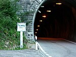
From Mümliswil to the top of the pass, the road overcomes 7.1 kilometers and 386 meters in altitude, which corresponds to an average gradient of 5.4%. The maximum gradient is 11%. About three kilometers before the top of the pass, a road branches off westwards towards the Schelten Pass . In the middle and upper part just before the pass, three switchbacks wind through the mountain. The pass, located entirely in the Solothurn canton, at 943 m above sea level. M. runs through an almost north-facing, 180-meter-long tunnel through the Jurafels. The narrow tunnel has no median markings. Large vehicles are only allowed to enter the tunnel without oncoming traffic.
The north-west ramp overcomes 11 kilometers from the pass to Erschwil 490 meters in altitude and thus corresponds to an average gradient of 4.5%. The maximum gradient is also 11%. In the upper part of the ramp there are three narrower and one more hairpin. From about the middle of the northwest ramp to Erschwil, the pass road runs parallel to the Lüssel , a right tributary of the Birs . At a bottleneck above Erschwil, a piece of the road runs over the so-called Long Bridge , which covers the Lüssel. Since the road was built around 1730, this has replaced a path that bypasses the gorge with a steep incline. The long bridge , which has been changed and widened since then, was considered a sight at the time of its construction and found its way into travel guides. As part of the renovation of the Passwangstrasse, the road is to be relocated at this point from 2020 and widened by rock excavation, the Lüssel will be exposed again.
The Passwangstrasse continues to be the shortest connection between the northern and southern parts of the canton of Solothurn, although its importance has declined due to the completion of the A 2 motorway and the opening of the Belchen tunnel in 1970.
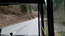
About the Passwang a wrong postal bus -line of forcing to Balsthal . Until the timetable change in December 2006, there were no continuous courses; separate courses from the north side ( Laufen / Zwingen) and the south side (Balsthal) each turned at the turning point at the north portal.
Old Passwangstrasse
The old Passwangstrasse on the south side is now partly paved and partly unpaved . A short stretch near the top of the pass still shows the old stone paving . The road is signposted as a hiking trail and is also used for forestry purposes. The route of the second Solothurn forest hike runs partly over the old Passwangstrasse, from which it branches off before it leads into the forest above Mümliswil.
On the north side, the course of the road after the expansion in 1931–1933 differs less strongly from the historical course since 1732 and, unlike on the south side, there is no continuous “old Passwangstrasse”. A stretch of the route above Erschwil, known as the Alte Passwangstrasse , is initially the course up to the relocation of this section to the orographically right bank of the Lüssel during the correction 1921–1923, which preceded the road construction 1931–1933. This path branches off - seen in the direction of Beinwil –Passwang - at the southern exit of the village, initially paved from the new Passwangstrasse and initially runs on the left bank of the Lüssel. After about 225 meters and after the junction of the short Kalchofenweg , the path splits into the Alte Forstweg , over which a hiking trail runs, and the rest of the Alte Passwangstrasse . After a few meters the path splits again; The forest path branches off to the right . The asphalting of the old Passwangstrasse ends at this point and it becomes a field or forest path. After a little less than a kilometer, it crosses the Lüssel and meets the new Passwangstrasse again at a narrow point, which from there follows the course as it was created around 1730 with the construction of the Long Bridge over the Lüssel. The historical path from the time before 1730 then runs on the other side of the slope past the St. Joseph chapel, roughly parallel to the new road, until it merges into it again before Unterbeinwil.
Passwangstrasse east of Beinwil, with the Hohe Winde (1204 m) in the center of the picture
South side: top of the pass with old sign and top tunnel

North side: General view of the Zingelen-Fluh with tunnel portal, assembled from individual images

Old Passwangstrasse coming from the south side shortly before the confluence with the new road on the Passwang north side (2019)


Processing in art and literature

The Long Bridge near Erschwil was depicted around 1760 by David Herrliberger in his topography of the Eydgnossschaft in a copper engraving after Emanuel Büchel as a strange bridge in the Canton of Solothurn .
In 1813 Peter Birmann drew a panorama showing the view from the Passwang. A watercolor view of the Bogental north of the Passwang with a view of the Vogelberg by Jakob Christoff Bischoff is also from this year. In the 1860s, Anton Winterlin published a Passwang panorama with a complete panoramic view as a lithograph . In 1906 another panorama appeared as a colored lithograph by Fritz Dürrenberger-Senn . Dürrenberger visited the Passwang for this panorama, which is considered to be particularly precise, about twenty times over a period of two years.
In his ballad Der Tod am Barschwang , the poet Albin Fringeli described a fatal landslide on the Passwang in the dialect of the Black Boy Country , in which, according to the assessment of the writer and journalist Thomas Brunnschweiler, "reaching the force of the ballads by Schiller ". During a storm, a farmhouse disappears under a «Strom vo Stei un Drägg»:
| Everything is buried in the eye, | Suddenly everything is buried |
| Dr Wääg struck through the valley durabe, | The way down through the valley is blocked, |
| Ghei Huus un Heimet isch meh z gseh, | No house and farm can be seen anymore |
| At the old place - a big lake. | At the old place - a big lake. |
| Dört un schloofe big and chly, | Big and small sleep down there, |
| The one where in the home stay sy. | The ones who stayed on the farm. |
From: Albin Fringeli, Der Tod am Barschwang .
The band Solothurn Tell (1972) by Elisabeth Pfluger has with Di guldigi Flue Sage rich one, swanky and towards the poor miserly Sennen on Passwang who does all in his craving for Zingelen-Fluh have had gild, but punished for it and to disaster had been overthrown: The willow had slipped away with his house and yard in a storm. "But the smooth Zingelflue shines no hüt i der Obesunne like the Guldgrund from the old image of the Mother of God" (But the smooth Zingelfluh still shines in the evening sun like the golden background of an old image of the Mother of God) . The sources of the legend were Emil Nussbaumer from Mümliswil (1967) and Johann Ankli from Beinwil (1970). Further stories from the Passwang area can also be found in Pfluger's publications Settigi Ding gids (2004) and Gschicht und Gschichte (2011).
In his book Dr Passwang-Louis (1997), which combines narrative and novel-like sections with elements of a non-fiction book, the writer Franz Walter reports on his search for traces of Luigi Bottati (1889–1981), an original known as “Passwang-Louis” . "Passwang-Louis" came from Northern Italy , came to Guldental as a worker in 1931 while building the Passwangstrasse and stayed in the area. In January 2020, the Konkordia Mümliswil music society performed a “musical picture arc” by Marco Nussbaumer based on the book and with Franz Walter as the narrator.
Sport and tourism
Cycling
In the Tour de Suisse , the Passwang was climbed a total of 18 times from 1934 to 2019 and, together with the Zurzacherberg, is one of the most traveled Swiss mountain passes under 1000 meters as well as one of the ten most traveled passes in the most important Swiss cycle race. The mountain pass is classified as a 2nd category mountain in the Tour de Suisse .
In addition to the respective winner of the mountain prize on the Passwang, the start and finish locations as well as the length of the stages are listed:
- 1937 : 8th stage: Solothurn- Zurich (210 km), mountain prize winner: Enrico Mollo
- 1939 : 1st stage: Zurich- Grenchen (219.6 km), mountain prize winner: Paul Egli
- 1948 : 2nd stage: Basel - La Chaux-de-Fonds (189.1 km): Mountain prize winner: Alfredo Pasotti
- 1950 : 2nd stage: Winterthur - Liestal (240 km), mountain prize winner: Fritz Zbinden
- 1957 : 3rd stage: Basel-La Chaux-de-Fonds (196 km), mountain award winner: Walter Holenweger
- 1960 : 7th stage: Montreux -Basel (239 km): Mountain prize winner: Wim van Est
- 1963 : 7th stage: Burgdorf - Bremgarten (196 km), mountain prize winner: Rolf Maurer
- 1965 : 1st stage: Murten -Basel (182 km), mountain prize winner: Karl Brand
- 1968 : 2nd stage: Langenthal - Binningen / Aesch (152 km), mountain prize winner: Mariano Díaz
- 1973 : 9th stage: Schupfart - Olten (97 km), mountain prize winner: José Manuel Fuente
- 1977 : 3rd stage: Möhlin -Olten (108.5 km), mountain prize winner: Horst Schütz
- 1978 : 4th stage: Oftringen -Solothurn (162 km), mountain prize winner: Mariano Martinez
- 1985 : 5th stage: Oberwil-Solothurn (73 km), mountain prize winner: Benny Van Brabant
- 1987 : 5th stage: Basel- Brügg (129.5 km), mountain prize winner : Guido Winterberg
- 1990 : 4th stage: Basel / Kaiseraugst -Solothurn (98 km), mountain prize winner: Robert Millar
- 1991 : 9th stage: Murten-Basel (196 km), mountain prize winner: Masatoshi Ichikawa
- 2002 : Mountain Prize Winner: Patrick Calcagni
Most recently, on July 18, 2019, the 4th stage of the 83rd edition of the Tour de Suisse led from Murten, in the northern canton of Friborg , over the Passwang to Arlesheim , south of Basel. The 163.9-kilometer route with an altitude of 1980 meters reached the Passwang after about half of the route. Taco Van der Hoorn from the Netherlands won the mountain prize on Passwang in 2019.
Hiking trails

The Passwang is a popular starting point for hikes . Between the Zingelen Tunnel and Passwanghöhe, official routes of the Swiss hiking trails lead in all directions, especially to the west to the Hohe Winde ; to the north in the direction of Nunningen or Wasserfallen or via the Wasserfallen area further east to Waldenburg or Oberen Hauenstein ; south to Mümliswil-Ramiswil (either via Hagli to Ramiswil or on the old Passwangstrasse to Mümliswil). The hiking trails in the Passwang area are all classified in the easiest category (yellow), with the exception of a steep path at the Wasserfallen, which is marked as a mountain hiking trail (white-red-white).
Passwang blocking point
The 20 kilometer long Passwangstrasse connects the Laufental with the Swiss plateau and is thus the north-western gateway to the center of the Swiss industrial zone. The road across the Passwang mountain pass was used to move border troops across the Jura during the First World War .
During the Second World War , deeply staggered, fortified barriers were created near the narrow passages of the Passwangstrasse in order to be able to prevent or stop a German advance from the north into the Central Plateau. These fortifications were added and expanded during the Cold War .
The construction and operation of the bunkers and anti-tank obstacles were part of the task of the Border Brigade 4 responsible for this border area . At Mümliswil there was a regimental command post and the Lobisei command post of Border Brigade 4, which was set up in 1942 and expanded in 1965 to become an independent "command fortress".
- Infantry bunker Lange Brücke, Erschwil A 3639 ⊙
- Infantry bunker Lange Brücke A 3640 ⊙
- Infantry bunker Schachen, Beinwil SO A 3641: 24 mm PzBk 38 ⊙
- Infantry bunker Schachen A 3642: Mg stand ⊙
- Infantry bunker Schachen A 3643: 7.5-cm-field gun, later 9-cm-Pak ⊙
- Infantry bunker Schachen A 3644: 7.5-cm-field gun, later 9-cm-Pak ⊙
- Geländepanzerhügel GPH with brook barrier Schachen ⊙
- Infantry bunker Neuhüsli A 3645 ⊙
- Infantry bunker Passwang Ost A 3648 ⊙
- Infantry bunker Passwang West A 3649 ⊙
- Infantry plant Pak A 3668 Mümliswil Süd ⊙
- Command post KP Lobisei Grenzbrigade 4 A 3669 Mümliswil ⊙
- Infantry bunker two 8.4 cm cannons A 3670 St. Wolfgang ⊙
- Regimental command post Rgt 49 F 4300 Herrenhüsli, Mümliswil ⊙
- Infantry bunker A 3672 Äussere Klus, Balsthal ⊙
- Infantry plant A 3673 above Gerbe, Balsthal ⊙
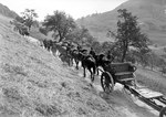
North side: «The 15 cm howitzer battery on the way to the Passwang», between 1914 and 1918

South side: "The horses of the howitzer battery are exhausted after the ascent", between 1914 and 1918

Infantry bunker A 3649 Passwang West

Memorial plaque of former army units on Passwang


literature
- Hans Mollet: On the geology of the Zingelentunnel of the new Passwangstrasse. In: Communications from the Solothurn Natural Research Society. Volume 9 (1928-1931), [1932], pp. 63-76, doi: 10.5169 / seals-543225 .
- Report on the construction of the Passwangstrasse. Construction Department of the Canton of Solothurn, Solothurn 1935.
- Max Banholzer: The Passwangstrasse . In: Jura leaves . tape 37 , no. 5 , 1975, p. 77-79 .
- Urs Wiesli: The old Passwangstrasse . In: Jura leaves . tape 57 , no. 12 , 1995, p. 185-189 .
- Dominik Wunderlin et al .: Wasserfallen, Passwang. A travel guide . Dietschi, Olten / Balsthal / Waldenburg 1998, ISBN 3-9520709-4-7 .
- Peter R. Huber: Employment measures in the canton of Solothurn in the interwar period. Expansion of the Passwangstrasse and thinning correction . In: Yearbook for Solothurn History . tape 85 , 2012, p. 147–288 , doi : 10.5169 / seals-392511 .
Web links
- Lukas Schenker: Passwang. In: Historical Lexicon of Switzerland .
- Passwang - description on regionatur.ch
- Passwang (943 m) - pass description on quaeldich.de
- Passwang - Tourist description on schweizmobil.ch
Remarks
- ↑ a b The field and settlement names of the Amtei Dorneck-Thierstein (= Solothurn name book. Volume 2). Edited by Markus Gasser and Thomas Franz Schneider. Schwabe, Basel 2010, ISBN 978-3-7965-2658-9 , pp. 655 f., Article Passwang .
- ^ The field and settlement names of the Dorneck-Thierstein district (= Solothurn name book. Volume 2). Edited by Markus Gasser and Thomas Franz Schneider. Schwabe, Basel 2010, ISBN 978-3-7965-2658-9 , pp. 655 f., Article Passwang; see. Passwang . In: ortsnames.ch . Retrieved November 1, 2019.
- ^ Charles Knapp, Maurice Borel, Victor Attinger, Heinrich Brunner, Société neuchâteloise de geographie (editor): Geographical Lexicon of Switzerland . Volume 3: Krailigen - Plentsch . Verlag Gebrüder Attinger, Neuenburg 1905, p. 707, keyword Passwang or Barschwang ( scan of the lexicon page ).
- ↑ a b Rolf Max Kully: The mountain name Passwang reinterpreted . In: Oltner Tagblatt . April 27, 2006 ( ortsnames.ch [PDF]).
- ^ The field and settlement names of the Dorneck-Thierstein district (= Solothurn name book. Volume 2). Edited by Markus Gasser and Thomas Franz Schneider. Schwabe, Basel 2010, ISBN 978-3-7965-2658-9 , pp. 655 f., Article Passwang; see. also Passwangstrasse . In: ortsnames.ch . Retrieved November 5, 2019.
- ↑ The field and settlement names of the Thal-Gäu district (= Solothurn name book. Volume 4). Edited by Beatrice Hofmann-Wiggenhauser and Jacqueline Reber. Schwabe, Basel 2017, ISBN 978-3-7965-3696-0 , p. 424, under the article Passwang .
- ↑ Urs Wiesli: Geography of the Canton of Solothurn . Kantonaler Lehrmittelverlag Solothurn, Solothurn 1969, p. 196 .
- ↑ Urs Wiesli: The old Passwangstrasse . In: Jura leaves . tape 57 , no. 12 , 1995, p. 185–189 , here p. 186 .
- ↑ a b c Urs Wiesli: The old Passwangstrasse . In: Jura leaves . tape 57 , no. 12 , 1995, p. 185–189 , here p. 187 .
- ↑ Urs Wiesli: Geography of the Canton of Solothurn . Kantonaler Lehrmittelverlag Solothurn, Solothurn 1969, p. 39 .
- ↑ Urs Wiesli: Geography of the Canton of Solothurn . Kantonaler Lehrmittelverlag Solothurn, Solothurn 1969, p. 41 .
- ↑ Urs Wiesli: Geography of the Canton of Solothurn . Kantonaler Lehrmittelverlag Solothurn, Solothurn 1969, p. 43 .
- ↑ Liasische stromatolithes, Passwang (mümliswil-ramiswil, SO). (PDF) Swiss Academies of Arts and Sciences , accessed on December 5, 2019 .
- ↑ Descriptions of the BLN objects . Swiss Confederation, Federal Office for the Environment FOEN. February 26, 2019. Retrieved on February 6, 2020. Document BLN 1012 Belchen-Passwang -gebiet.pdf contained in the ZIP file linked there 10 chain and plateau jura .
- ↑ a b c Lukas Schenker: Passwang. In: Historical Lexicon of Switzerland . April 22, 2009 , accessed November 1, 2019 .
- ^ Max Banholzer: The Passwangstrasse . In: Jura leaves . tape 37 , no. 5 , 1975, p. 77–79 , here p. 77 .
- ↑ a b Oliv Jeker: The old Passwangstrasse . In: Report on the construction of the Passwangstrasse . Construction Department of the Canton of Solothurn, Solothurn 1935, p. 1-2 .
- ↑ Urs Peter Strohmeier: The canton of Solothurn, historically, geographically, statistically described . Huber, St. Gallen / Bern 1836, p. 36 ( e-rara.ch ).
- ↑ Oliv Jeker: The old Passwangstrasse . In: Report on the construction of the Passwangstrasse . Construction Department of the Canton of Solothurn, Solothurn 1935, p. 6 .
- ↑ Oliv Jeker: The old Passwangstrasse . In: Report on the construction of the Passwangstrasse . Construction Department of the Canton of Solothurn, Solothurn 1935, p. 8 .
- ^ Peter R. Huber: Job creation measures in the canton of Solothurn in the interwar period. Expansion of the Passwangstrasse and thinning correction . In: Yearbook for Solothurn History . tape 85 , 2012, p. 147–288 , here pp. 207–208 , doi : 10.5169 / seals-392511 .
- ^ Max Banholzer: The Passwangstrasse . In: Jura leaves . tape 37 , no. 5 , 1975, p. 77–79 , here p. 78 .
- ↑ a b Werner Reber: On the traffic geography and history of the passes in the eastern Jura (= sources and research on the history and regional studies of the canton of Basel-Landschaft . Volume 11 ). Cantonal print and material center, Liestal 1970, p. 174 .
- ^ Peter R. Huber: Job creation measures in the canton of Solothurn in the interwar period. Expansion of the Passwangstrasse and thinning correction . In: Yearbook for Solothurn History . tape 85 , 2012, p. 147–288 , here p. 209 , doi : 10.5169 / seals-392511 .
- ^ Peter R. Huber: Job creation measures in the canton of Solothurn in the interwar period. Expansion of the Passwangstrasse and thinning correction . In: Yearbook for Solothurn History . tape 85 , 2012, p. 147–288 , here p. 212 , doi : 10.5169 / seals-392511 .
- ^ Report on the construction of the Passwangstrasse. Construction Department of the Canton of Solothurn, Solothurn 1935, pp. 14–21.
- ^ Report on the construction of the Passwangstrasse. Construction Department of the Canton of Solothurn, Solothurn 1935, p. 21.
- ^ Peter R. Huber: Job creation measures in the canton of Solothurn in the interwar period. Expansion of the Passwangstrasse and thinning correction . In: Yearbook for Solothurn History . tape 85 , 2012, p. 147–288 , here pp. 126–127 , doi : 10.5169 / seals-392511 .
- ^ Peter R. Huber: Job creation measures in the canton of Solothurn in the interwar period. Expansion of the Passwangstrasse and thinning correction . In: Yearbook for Solothurn History . tape 85 , 2012, p. 147–288 , here p. 223 , doi : 10.5169 / seals-392511 .
- ^ Peter R. Huber: Job creation measures in the canton of Solothurn in the interwar period. Expansion of the Passwangstrasse and thinning correction . In: Yearbook for Solothurn History . tape 85 , 2012, p. 147–288 , here pp. 218–220 , doi : 10.5169 / seals-392511 .
- ↑ Dominik Wunderlin: Over and through the Passwang - of road projects and broken railway spaces . In: Wasserfallen, Passwang. A travel guide . Dietschi, Olten / Balsthal / Waldenburg 1998, ISBN 3-9520709-4-7 , p. 62–73 , here p. 67 .
- ↑ Dominik Wunderlin: Over and through the Passwang - of road projects and broken railway spaces . In: Wasserfallen, Passwang. A travel guide . Dietschi, Olten / Balsthal / Waldenburg 1998, ISBN 3-9520709-4-7 , p. 62–73 , here p. 68 .
- ↑ Josef Tschan-Studer: oncoming traffic, stones and avalanches: The Passwang must be rehabilitated . In: Solothurner Zeitung . November 23, 2011. Retrieved November 3, 2019.
- ^ Fränzi Zwahlen-Saner: A bridge on the mountain: rehabilitation of the pass road with unusual means . In: Solothurner Zeitung . June 12, 2016. Retrieved November 3, 2019.
- ↑ Expensive renovation: Additional loan for Passwangstrasse causes severe criticism . In: Regional Journal Aargau / Solothurn . SRF. March 8, 2017. Retrieved November 3, 2019.
- ^ «Solothurn Heimatschutzpreis 2019» cultural heritage Passwangstrasse . Solothurn Homeland Security. Retrieved November 3, 2019.
- ↑ Actually, the (new) Passwangstrasse branches off at this point from the previously existing Scheltenpassstrasse, which is, however, less developed.
- ↑ Dominik Wunderlin: Over and through the Passwang - of road projects and broken railway spaces . In: Wasserfallen, Passwang. A travel guide . Dietschi, Olten / Balsthal / Waldenburg 1998, ISBN 3-9520709-4-7 , p. 62–73 , here p. 64 .
- ↑ The "Long Bridge" has to be replaced: Passwangstrasse is relocated . In: Solothurner Zeitung . November 4, 2019. Retrieved February 5, 2020.
- ↑ Passwang Line . PostBus AG. Retrieved November 3, 2019.
- ↑ Switzerland. Official course book . Volume buses, 2005/2006 and 2006/2007, timetable fields 230.55 and 412.15.
- ↑ 2. Solothurn forest hike: Alte Passwangstrasse (PDF; 2.11 MB) Canton Solothurn, Office for Forests, Hunting and Fishing. Retrieved November 9, 2019.
- ↑ Urs Wiesli: The old Passwangstrasse . In: Jura leaves . tape 57 , no. 12 , 1995, p. 185–189 , here p. 186 .
- ↑ 2. Solothurn forest hike: airy ridges, deep gorges (PDF; 1.23 MB) Canton Solothurn, Office for Forests, Hunting and Fishing. Retrieved November 9, 2019.
- ↑ Maps of Switzerland . Swiss Confederation, Federal Office of Topography. Retrieved February 9, 2020.
- ↑ As of February 9, 2020, the Alte Passwangstrasse is not shown on Google Maps from this point onwards and the course of the forest path is incorrectly shown as the Alte Passwangstrasse . The correct route can be found on the online national map of Switzerland with the data from the official road directory.
- Jump up to: Maps of Switzerland . Swiss Confederation, Federal Office of Topography. Retrieved February 9, 2020.
- ^ René Salathé: The Passwang in art . In: Wasserfallen, Passwang. A travel guide . Dietschi, Olten / Balsthal / Waldenburg 1998, ISBN 3-9520709-4-7 , p. 35-40 .
- ^ Thomas Brunnschweiler: Significant double anniversary . In: Weekly newspaper for the Schwarzbubenland and the Laufental . May 15, 2019. Retrieved November 16, 2019.
- ↑ Albin Fringeli: On the trail of those who stay . Lenos Verlag, Basel 2011, ISBN 978-3-85787-417-8 , pp. 143–145 , here p. 145 .
- ↑ Elisabeth Pfluger: Di guldigi Flue . In: Solothurn legends . State Chancellery of the Canton of Solothurn, Solothurn 1972, p. 232-233 .
- ^ Elisabeth Pfluger: Solothurn legends . State Chancellery of the Canton of Solothurn, Solothurn 1972, p. 408 .
- ^ Franz Walter: Dr Passwang-Louis . Editions Heuwinkel, Carouge / Genève / Neu-Allschwil / Basel 1997, ISBN 3-906373-14 ( defective ) , p. 20-28 .
- ^ Fränzi Zwahlen-Saner: "Dr Passwang Louis" - the life of the vagabond becomes a musical event . In: Solothurner Zeitung . September 26, 2019. Accessed January 12, 2020.
- ^ Fränzi Zwahlen-Saner: "I saw visitors with tears in my eyes": a musical narrative by Passwang-Louis . In: Solothurner Zeitung . January 19, 2020. Accessed February 2, 2020.
- ↑ Statistics document of the Tour de Suisse (PDF), u. a. Pp. 58, 64, accessed November 8, 2019
- ↑ tourdesuisse.ch: March table of the 4th stage Murten-Arlesheim 163.9 km , accessed on November 8, 2019
- ↑ Results of the 4th stage, Tour de Suisse 2019 , accessed on November 8, 2019
- ↑ Solothurn hiking trails: Solothurnerland hiking book . Raiffeisen banks, Solothurn 2007, p. 70 .
- ↑ Maps of Switzerland with hiking trails . Swiss Confederation, Federal Office of Topography. Retrieved March 1, 2020.
- ↑ Maps of Switzerland with hiking trails . Swiss Confederation, Federal Office of Topography. Retrieved March 1, 2020.
- ↑ Lock point Schachen (Beinwil SO) . In: Fortress Oberland . Retrieved January 19, 2020.
- ↑ Lock point Passwang SO . In: Fortress Oberland . Retrieved January 19, 2020.
- ↑ A3669 Command Post Border Brigade 4 Lobisei . In: Fortress Oberland . Retrieved January 19, 2020.
Ächerli • Agites • Aiguillon • Albis • Albula • Balmberg • Benkerjoch • Bernina • Böhler • Bözberg • Breitehöchi • Brünig • Buechenegg • Bürersteig • Chall • Challhöchi Pass • Champex • Chasseral • Chatzenstrick • Chilchzimmersattel • Croix • Croix • Croix de Coeur • Eichhöhe • Étroits • Etzelpass • Flüela • Forclaz • Furka • Ghöch • Givrine • glass • Glaubenberg • Glaubenbielen • Gottschalkenberg • Grimsel • Grosse Scheidegg • Gr.St.Bernhard • Gurnigel • Haggenegg • Hahnenmoos • Heitersberg • Hilferen • Hirzel • Hirzel Höhi • Hulftegg • Ibergeregg • Jaman • Jaun • Julier • Kerenzerberg • Klausen • Kunkels • Lein • Lenzerheide • Livigno • Lukmanier • Maloja • Marchairuz • Mollendruz • Mont Crosin • Monte Ceneri • Mont d'Orzeires • Montvoie • Morgins • Mosses • Mutschellen • Neggia • Nufenen • Oberalp • upper Hauenstein • Oberricken • oven • Orn • Passwang • Pierre Pertuis • Pillon • Planches • Pontins • Pragel • edge crossing • Rangiers • rates • Rengg • crocheted • Roches • 'groups • R üsler • Saanenmöser • Salhöhe • San Bernardino • Sanetsch • Santelhöchi • Sattel • Sattelegg • Schafmatt • Schallenberg • Schelten • Schönau • Schufelberger Egg • Schwägalp • Schwarzenbühl • Siblingerhöhe • Simplon • Splügen • St. Anton • St. Gotthard • St. Luzisteig • Staffelegg • Stoss • Susten • Tourne • Tronc • Umbrail • Unterer Hauenstein • Front Höhi • Vue des Alpes • Wasserfluh • Weissenstein • Wildhaus • Wissegg • Wolfgang