
Waldenburg BL
| BL is the abbreviation for the canton Basel-Landschaft in Switzerland and is used to avoid confusion with other entries of the name Waldenburg . |
| Waldenburg | |
|---|---|
 |
|
| State : |
|
| Canton : |
|
| District : | Waldenburg |
| BFS no. : | 2895 |
| Postal code : | 4437 |
| Coordinates : | 623 397 / 248062 |
| Height : | 528 m above sea level M. |
| Height range : | 509–1168 m above sea level M. |
| Area : | 8.32 km² |
| Residents: | 1081 (December 31, 2018) |
| Population density : | 130 inhabitants per km² |
| Website: | www.waldenburg.ch |
 Waldenburg |
|
| Location of the municipality | |
  |
|
Waldenburg (in the Swiss German local dialect Wolbe (r) g, regionally also Waldebu (r) g ) is a political municipality and capital of the district of the same name in the Swiss canton of Basel-Landschaft .
geography

Waldenburg is located at the upper end of the front Frenkental (also called Waldenburgertal). The highest point in the canton of Baselland is in the Waldenburg area. It is the Hinteri Egg at 1169 meters above sea level. M.
Waldenburg borders on the municipalities of Reigoldswil and Liedertswil in the west of Basel , Oberdorf in the north and east and Langenbruck in the east and south. In the south and southwest, along with the border with the municipality of Mümliswil-Ramiswil , the canton border between Baselland and Solothurn also runs .
history
Waldenburg was first mentioned in 1244 as Waldenburch . The name is either a reinterpretation from Wal (h) enburg, which means castle of the Walchen or the Welschen , or a combination with the Old High German personal name Waldo . While the lexicon of Swiss municipality names tends towards the second explanation due to the first evidence, the editors of the Baselbieter name book prefer the first explanation due to the local vernacular pronunciation and the frequency of whale (h) en names in the Basel area.
Archaeological finds indicate that the Romans already had a defense structure in the area of the later municipality to secure the Upper Hauensteinstrasse. In the Middle Ages the area belonged to Onoldswil , which was owned by Alsatian monks. When the Gotthard Pass was opened, Hermann von Froburg founded the little town of Waldenburg, which came into the possession of the bishop in 1366 and the city of Basel in 1400 . In 1833, Waldenburg became the district capital in the newly founded canton of Basel-Landschaft .
coat of arms
Waldenburg has had an official coat of arms since 1926. It shows an eagle with blue and white patterned feathers, a red beak, a red tongue and red claws on a gold shield. It is the eagle from the shield of the Counts of Frohburg .
traffic
Waldenburg is located on Hauptstrasse 12 , which connects Liestal in the canton of Basel-Landschaft via the Upper Hauenstein with Balsthal in the canton of Solothurn .
Waldenburg is the terminus of the Waldenburgerbahn , an electrified, originally steam-powered 75 cm narrow-gauge railway, which leads from Waldenburg to the canton capital Liestal.

In Waldenburg

Waldenburg station

school


Attractions
- The reformed parish church with glass panes by Jacques Düblin is well worth seeing and was built in 1833–1842 through the renovation of the granary.

Church window in the Reformed Church of St. Peter, donated by Charles Schäublin

_(3).jpg)
_(4).jpg)
- The late Gothic rectory with its painted ceiling was the seat of a noble gentleman before 1573.
- Medieval city center
- The Waldenburg ruins were a fortress of the Frohburg family; she was cremated in 1798.
- A steam locomotive from 1902 of the type WB G 3/3 , with rolling stock from the Wilhelminian era, is parked next to the Talhaus restaurant ( Bubendorf BL ) in a remise built in 2018.

Old town with church
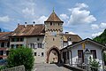
Upper city gate

Waldenburgerli "Gedeon Thommen"

In 1797 Napoleon Bonaparte stayed in the Gasthof zum Schlüssel.

Carl Spitteler in Waldenburg


.jpg)
.jpg)
literature
- Bernard Degen : Waldenburg (community). In: Historical Lexicon of Switzerland .
- Axel Christoph Gampp, Sabine Sommerer: The art monuments of the canton Basel-Landschaft IV. The district Waldenburg. (= Art Monuments of Switzerland. Volume 124). Edited by the Society for Swiss Art History , Bern 2014, ISBN 978-3-03797-115-4 .
Web links
Individual evidence
- ↑ Permanent and non-permanent resident population by year, canton, district, municipality, population type and gender (permanent resident population). In: bfs. admin.ch . Federal Statistical Office (FSO), August 31, 2019, accessed on December 22, 2019 .
- ^ Linguistic Atlas of German-speaking Switzerland , Volume V 1b; Lexicon of Swiss municipality names, ed. from the Center de Dialectologie at the University of Neuchâtel under the direction of Andres Kristol, Frauenfeld / Lausanne 2005, p. 949.
- ↑ The place and field names of the canton of Basel-Landschaft. Waldenburg district (= Baselbieter name book. Vol. 7). Ed. And edit. by Heinrich Hänger. Verlag des Kantons Basel-Landschaft, Liestal 2017, p. 22 f .; Markus Ramseier , Béatrice Wiggenhauser, Daniel Krieg: Name book of the communities in the canton of Basel-Landschaft, Waldenburg booklet . Pratteln 2003, p. 5; Lexicon of Swiss municipality names , ed. from the Center de Dialectologie at the University of Neuchâtel under the direction of Andres Kristol, Frauenfeld / Lausanne 2005, p. 949.
- ^ Baselland: Waldenburg cultural assets
- ↑ Waldeburgerli: historic steam locomotive in depot