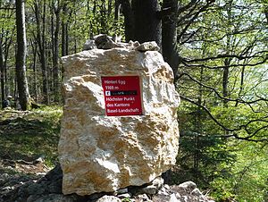
Hinteri Egg
| Hinteri Egg | ||
|---|---|---|
|
On the summit of the Hinteri Egg |
||
| height | 1169 m above sea level M. | |
| location | Canton of Basel-Country , Switzerland | |
| Mountains | law | |
| Dominance | 1.93 km → Vogelberg | |
| Notch height | 165 m ↓ Rear waterfalls | |
| Coordinates | 620 560 / 246 890 | |
|
|
||
The Hinteri Egg is a mountain in the Swiss Jura with a height of 1169 m above sea level. M.
It is the highest point in the canton of Basel-Landschaft . In 2008 this fact was marked with an inscription.
The mountain is located in the municipality of Waldenburg between the Waldenburgertal and the Reigoldswil valley . The waterfall mountain crossing is about one kilometer southwest of the summit. The mountain area is located in the Basel nature reserve "Wasserfallen", Reigoldswil and Waldenburg .
Only around two hundred meters south of it is the Chellenchöpfli pre-summit , over which the canton border between Baselland and the canton of Solothurn runs. While the summit zone of the Hinteren Egg is forested, the Chellenchöpfli offers a wide view of the Guldental valley to the south and the Alps .
The Hinteri Egg- Passwang ridge is well developed with a network of hiking trails.
Individual evidence
- ↑ Ordinance on the "Wasserfallen" nature reserve, Reigoldswil and Waldenburg of March 1, 2011 , on lexfind.ch, accessed on March 18, 2019.

