
Lauwil
| Lauwil | |
|---|---|
 |
|
| State : |
|
| Canton : |
|
| District : | Waldenburg |
| BFS no. : | 2889 |
| Postal code : | 4426 |
| Coordinates : | 617.9 thousand / 248840 |
| Height : | 633 m above sea level M. |
| Height range : | 559–1164 m above sea level M. |
| Area : | 7.30 km² |
| Residents: | 326 (December 31, 2018) |
| Population density : | 45 inhabitants per km² |
| Website: | www.lauwil.ch |
 Lauwil |
|
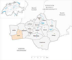
| Location of the municipality | |
  |
|


Lauwil ( Swiss German : Louel ) is a municipality in the Waldenburg district of the canton of Basel-Landschaft in Switzerland .
geography
Lauwil lies at the foot of the Baselland Jura chain. The village lies at 634 m and belongs to the Waldenburg district . Its neighboring communities are Reigoldswil , Bretzwil , Nunningen , Mümliswil-Ramiswil and Beinwil .
history
Luiwilre is mentioned for the first time in 1194. In the Middle Ages Lauwil belonged to the Froburg rule of Waldenburg . But the Lords of Ramstein and the Schöntal monastery also owned the village .
In 1949, during excavations, the remains of the medieval church of St. Romai (St. Remigius) were found, which was probably the center of a parish in Reigoldswil-Lauwil. There was also a St. Hilary Chapel at the foot of the waterfall. St. Romai burned down in 1536 and was rebuilt in Reigoldswil in 1562 with the same name. From 1555 on, Reigoldswil-Lauwil was ecclesiastically linked to Bretzwil, and since 1765 Lauwil and Bretzwil have formed a parish.
coat of arms
The municipal coat of arms is reminiscent of Lauwil's landmark , the Hochwacht. In the time of the separation struggles , the idea of high watch revived when it was a matter of bringing help to the isolated communities loyal to the city. The Baloise had in 1832 one provided with strong guard signal built on an exposed mountain range of the Vogelsberg in Lauwil that you temporarily removed in the spring of 1833 after a complaint to the other party, but decided to leave the post. When creating the municipal coat of arms, the municipality of Lauwil included the Hohwachtfire as a symbol in its municipal coat of arms in memory of the historical events . The coat of arms shows three red flames over a green five-mountain on a silver background, the Lauwiler flag is white-red.
Economy / infrastructure
Lauwil has many agricultural and local businesses, including two restaurants and a village shop. There is a kindergarten and a school in the village (with lower and intermediate levels). Secondary schools are located in the neighboring municipality of Reigoldswil.
traffic
Lauwil is not in through traffic as the cantonal road ends in Lauwil (Sackdorf). For public transport, the bus route 91 of the Basellandschaftliche Verkehrsbetriebe with Bretzwil and Reigoldswil is available. At the latter location there is a connection to bus line 70 to Liestal . The bus route 91 is partly extended to Waldenburg, where there is a connection to the Waldenburgerbahn .
Attractions
- Wasserfallen hiking and recreation area (Vogelberg mountain restaurant)
- Bird ringing Ulmethöhe (autumn)
- Whiskey distillery in Hollen
- Flying area delta and paragliding
photos

village street

school
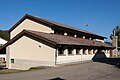
gym


literature
- Axel Christoph Gampp, Sabine Sommerer: The art monuments of the canton Basel-Landschaft IV. The district Waldenburg. (= Art Monuments of Switzerland. Volume 124). Edited by the Society for Swiss Art History , Bern 2014, ISBN 978-3-03797-115-4 .
Web links
- Official website of the municipality of Lauwil
- Dominik Wunderlin: Lauwil. In: Historical Lexicon of Switzerland .
Individual evidence
- ↑ Permanent and non-permanent resident population by year, canton, district, municipality, population type and gender (permanent resident population). In: bfs. admin.ch . Federal Statistical Office (FSO), August 31, 2019, accessed on December 22, 2019 .