
Beinwil SO
| SO is the abbreviation for the canton of Solothurn in Switzerland and is used to avoid confusion with other entries of the name Beinwil . |
| Beinwil | |
|---|---|
 |
|
| State : |
|
| Canton : |
|
| District : | Thierstein |
| BFS no. : | 2612 |
| Postal code : | 4229 |
| Coordinates : | 611 247 / 245905 |
| Height : | 582 m above sea level M. |
| Height range : | 506–1205 m above sea level M. |
| Area : | 22.66 km² |
| Residents: | 283 (December 31, 2018) |
| Population density : | 12 inhabitants per km² |
| Website: | www.beinwil-so.ch |
 |
|
| Location of the municipality | |
  |
|
Beinwil is a municipality in the Thierstein district in the canton of Solothurn in Switzerland .
geography
Beinwil lies at 582 m above sea level. M. , around 9 km southeast of the city of Laufen (linear distance). The scattered settlement community extends in the valley of the Lüssel , at the northern foot of the Hohe Winde , in the Solothurn Jura and in the Schwarzbubenland . The area of the canton's third-largest municipal area with 22.7 km² includes a strongly reliefed and chambered section of the Jura . Almost the entire upper catchment area of the Lüssel belongs to Beinwil. The Lüssel crosses the area in a deep valley from east to west and takes on numerous short side streams on its way from both sides, which subdivide the landscape into a complicated system of valleys, hills and rocky crests. It enters the community ban near the Chessiloch at Passwang and leaves it at the narrow point between the Hörnli ( 816 m above sea level ) and the Hochstelleli ( 907 m above sea level ) above Erschwil.
The northern border seems to be drawn more or less arbitrarily and does not run along conspicuous natural features (mountain ridges, streams), but from the Hochstelleli along the southern slopes of the Hirnichopf to the Geissberg ( 1045 m above sea level ). In contrast, the southern municipal boundary lies mainly on the watershed. The Lüsseltal is flanked in the south by the heights of the Hörnli , Grand Mont ( 1073 m above sea level ), Hohe Winde (at 1204 m above sea level , it reaches the highest point in Beinwil) and the long but very narrow ridge of the Beibelberg (up to 1022 m above sea level ), which separates the upper Lüsseltal from the Guldental (in the catchment area of the Dünnern ). A small part of the community is located south of the Hohe Winde in the headwaters of the Scheltenbach . The municipality floor extends to the Scheltenpass ( 1051 m above sea level ) and to the Matzendörfer Stierenberg (up to 1170 m above sea level ). In 2014, 2% of the municipal area was accounted for by settlements, 54% for forests and woodlands and 43% for agriculture; slightly less than 1% on unproductive land.
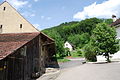
Beinwil is made up of four hamlet-like densities, all of which are in or near the valley floor of the Lüssel:
- Neuhüsli ( 650 m above sea level ) and Schachen ( 594 m above sea level ) together form Oberbeinwil
- the monastery district ( 582 m above sea level ) and Joggenhus ( 534 m above sea level ) together form Unterbeinwil
In addition, numerous individual farms, mountain farms and dairy farms, which are scattered over the entire area, belong to Beinwil. Neighboring communities of Beinwil are Mümliswil-Ramiswil , Aedermannsdorf , Erschwil , Meltingen and Nunningen in the canton of Solothurn, Bretzwil and Lauwil in the canton of Basel-Landschaft , Schelten in the canton of Bern and Mervelier and Montsevelier in the canton of Jura .
population
With 283 inhabitants (as of December 31, 2018), Beinwil is one of the small communities in the canton of Solothurn. 97.4% of the residents are German-speaking, 1.0% French-speaking and 1.0% speak Serbo-Croatian (as of 2000). The population of Beinwil was 506 in 1850, compared with 435 in 1900. During the 20th century, the population hovered between 410 and 480 people until 1950. Since then a slow but continuous decrease in population has been recorded.
economy
Beinwil still lives mainly from agriculture . Above all, dairy farming and cattle breeding are important in addition to fruit growing (mainly cherry trees), while arable farming only makes up a small proportion of the area due to the altitude. Some other jobs are available in local small businesses and in the service sector. In the past there was also industrial trade in the village, namely through iron mining in the 16th century and the establishment of a glassworks in 1835. Whey cures were carried out in Neuhüsli in the 19th century. Various workers are commuters who mainly work in the Laufental.
traffic
The community is located on the road from Zwingen over the Passwang to Balsthal . The various hamlets of Beinwil are connected to the public transport network by means of a post bus course , which covers the route from Zwingen to Oensingen .
history
The history of Beinwil is closely linked to that of the Benedictine monastery of Beinwil . The first written mention of the place took place in 1147 under the name Benwilre . Later the names Beinwilare (1156), Benvilare (1174), Beinwilre (1212), Beunwilre (1219), Beinwilr (1252) and Benwilr (1253) appeared. The place name goes back to the Old High German personal name Beino or Peino , possibly also Bago and thus means court settlement of Beino .
The Beinwil monastery was probably founded by the local nobility around 1085 (mother monastery Hirsau ) and given a domain that roughly corresponded to today's municipality and was then called the Beinwil Abbot Chamber . Already in the 12th century the monastery experienced a heyday (including double monastery monks and nuns approx. 100 years, pilgrimage to Rome & Santiago, various monastery courtyards, cheese dairy, blacksmith's, sawmill, ore mining, school, scriptorium, library with 200 manuscripts, hospice) and brought the church set of numerous localities in the Schwarzbubenland and the surrounding regions as well as various properties that reached as far as Alsace and Breisgau (60 estates including Lüsseltal Fricktal Breisgau Alsace F-Auxerre).
As early as the 13th century, the gradual economic decline began as a result of disputes over territorial claims of the cities of Solothurn and Basel to the Counts of Thierstein, who acted as castles of the monastery. After Beinwil came to Solothurn in 1519, the people of Solothurn also took over a large part of the monastery property as pledge. Beinwil was assigned to the Thierstein Bailiwick. In 1648 the monastery was moved to Mariastein because of the better future prospects there.
After the collapse of the Ancien Régime (1798), Beinwil belonged to the Dornach district during the Helvetic Republic and to the Thierstein district from 1803. The monastery was abolished by referendum during the Kulturkampf in 1874. The monastery complex has belonged to an ecumenical foundation (Roman Catholic and Protestant regional church) since the complete reconstruction in 1982. From 1982 to 2018 the monastery was kept open by the ecumenical community for all people regardless of religion (time out, Bible garden, monastery tour). Beinwil Monastery became an Orthodox monastery in 2019.
photos

The inside of the monastery church

Oberbeinwil

Beinwil Abbey, between 1836 and 1837

Unterbeinwil
Beinwil, settlement around the former monastery


Attractions
The baroque abbey church of Beinwil Abbey and the convent buildings were rebuilt at the end of the 17th century (guided tours possible by prior arrangement). Above the monastery is the St. John's Chapel, which was built in 1695 on the foundations of the Fridolins Chapel, which originally dates from the 5th century.
coat of arms
- Two slanted white bones in black
The two bones appear in abbey and convent seals of the Beinwil-Mariastein monastery as early as the 17th century. A reference to the place name Beinwil is not conclusively secured.
literature
- Gottlieb Loertscher: The art monuments of the canton of Solothurn, Volume III: The districts of Thal, Thierstein, Dorneck. (= Art Monuments of Switzerland. Volume 38). Edited by the Society for Swiss Art History GSK. Bern 1957, DNB 750089342 .
Web links
- Official website of the municipality of Beinwil
- Lukas Schenker: Beinwil (SO). In: Historical Lexicon of Switzerland .
Individual evidence
- ↑ Permanent and non-permanent resident population by year, canton, district, municipality, population type and gender (permanent resident population). In: bfs. admin.ch . Federal Statistical Office (FSO), August 31, 2019, accessed on December 22, 2019 .