
Breitenbach SO
| SO is the abbreviation for the canton of Solothurn in Switzerland and is used to avoid confusion with other entries of the name Breitenbach . |
| Breitenbach | |
|---|---|
 |
|
| State : |
|
| Canton : |
|
| District : | Thierstein |
| BFS no. : | 2613 |
| Postal code : | 4226 |
| Coordinates : | 607 988 / 250841 |
| Height : | 392 m above sea level M. |
| Height range : | 372–621 m above sea level M. |
| Area : | 6.80 km² |
| Residents: | 3854 (December 31, 2018) |
| Population density : | 567 inhabitants per km² |
| Website: | www.breitenbach.ch |
_677.JPG) |
|
| Location of the municipality | |
  |
|
Breitenbach is a political municipality and capital of the Thierstein district in the canton of Solothurn in Switzerland . The former French name is Bretonbac .
geography
Breitenbach is 392 m above sea level. M. , 4 km east-southeast of the city of Laufen (linear distance). The clustered village extends in the Lüsseltal, mainly on the eastern side of the Lüssel and on both sides of the village stream that flows into it, in the southern part of the Laufen basin in the Jura , in the Schwarzbubenland .
The area of the approximately 6.8 km², elongated in west-east direction, includes a section of the northern Jura. The western part of the municipality is located in the inner Jurassic Laufen basin. The Lüssel crosses the area with a flat valley floor about 1 km wide from south to north. To the west of the Lüsseltal is the ridge of the Pfaffenberg ( 435 m above sea level in the Äschjurten ).
To the east, the municipality extends into the valley basin of the village stream and onto the terrain that gradually rises to the hills of the Folded Jura with the heights of Helgenmatt ( 563 m above sea level ), Lenen ( 585 m above sea level ) and Littstelchöpfli on the at 621 m above sea level M. the highest point of Breitenbach is reached. The eastern border is formed by the Kaltbrunnental , a southern side valley of the Birs . In 2014, 20% of the municipal area was accounted for by settlements, 35% for forests and woodlands, 44% for agriculture and 1% for unproductive land.
Some individual farms belong to Breitenbach. The neighboring communities of Breitenbach are Himmelried , Nunningen , Fehren and Büsserach in the canton of Solothurn and Wahlen and Brislach in the canton of Basel-Landschaft .
population
With 3854 inhabitants (as of December 31, 2018), Breitenbach is one of the medium-sized communities in the canton of Solothurn. 82.6% of the residents speak German, 4.2% speak Italian and 2.8% speak Portuguese (as of 2000). The population of Breitenbach was 624 inhabitants in 1850 and 590 inhabitants in 1900. During the 20th century the population increased continuously. Particularly high growth rates were recorded from 1950 to 1970 and since 1980 (2518 inhabitants). Today, the settlement area of Breitenbach has grown together almost completely with those of Büsserach and Brislach.
economy
Until the first half of the 20th century, Breitenbach was a predominantly agricultural village. There used to be sawmills, tanneries and mills that were operated by the water power of the Lüssel. In the second half of the 19th century, four wood turneries and in 1882 a clock factory were founded. The actual industrialization of Breitenbach took off shortly after the turn of the century with the founding of Isola-Werke (1903) and Brac AG (1904; plastics technology).
Today Breitenbach offers around 2200 jobs. With 2% of the gainfully employed who are still employed in the primary sector, agriculture (predominantly arable farming , dairy farming and forestry ) only has a minor role in the employment structure of the population. Around 54% of the workforce is employed in the industrial sector, while the service sector accounts for 44% of the workforce (as of 2001).
In the course of the 20th century, large industrial and commercial zones developed, especially along the Lüssel and in the south-western part of the village. In Breitenbach today there are companies in the construction and transport industry, the manufacture of insulation material and cables ( Von Roll Schweiz AG), mechanical engineering, plastics processing, horticulture, the electrical industry, the advertising industry, a tape factory and mechanical workshops. There are also various trading companies and numerous companies active in the tertiary sector.

Breitenbach has been the location of the Thierstein District Hospital since 1929. It also has a district school and a special education school. In the last few decades the village has also developed into a residential community. New residential quarters emerged mainly on the promising slopes east of the village center. Many employees are therefore commuters who work mainly in Laufen and the Basel agglomeration .
Breitenbach has a natural pond that is open to the public as an outdoor pool.
traffic
The community is very well developed in terms of transport. It is located at the intersection of the streets from Zwingen over the Passwang to Balsthal and from Laufen to Liestal . Breitenbach is connected to the public transport network through the PostBus courses, which cover the routes from Laufen to Nunningen and from Zwingen to Beinwil .
history

The municipality of Breitenbach was inhabited very early, which has been proven by finds from the Bronze Age and the La Tène period, as well as remains of a Roman settlement. The place was first mentioned in a document in 1152 under its current name. The spellings Breittenbach (1362) and Breytenbach (1365) appeared later . The place name is originally derived from a water body name.
Since it was first mentioned, Beinwil Abbey has maintained a Dinghof in Breitenbach. From the 12th century the village belonged to the domain of the Counts of Thierstein. After the Thierstein family had died out, Breitenbach came to Solothurn in 1522 and was assigned to the Thierstein bailiwick. During the Thirty Years War , the village was repeatedly affected by Swedish troops. During the Peasants' War , Breitenbach developed into a trouble spot and center of the uprising against the Solothurn authorities.
After the collapse of the Ancien Régime (1798), Breitenbach belonged to the Dornach district during the Helvetic Republic and to the Thierstein district from 1803. It has been the district capital by law since 1831. At the turn of the century, rapid industrialization set in (establishment of the Isola works, which today belong to Von Roll), which led to a strong increase in the population. Breitenbach thus developed into the center of the Thierstein district and the second largest municipality in the Laufen basin.
Attractions
The original parish church of Breitenbach, which has been mentioned since the 13th century, stood in Rohr at the northern exit of the village, which is why the parish was previously called Rohr-Breitenbach. Today's pipe chapel was built in 1865; next to it is the old rectory. From 1845 to 1850 the new Catholic church was built in the center of the village, although it had to give way to a modern concrete structure at the beginning of the 1960s. The Sankt Fridolinskapelle standing in the open field southwest of Breitenbach was built in 1634.
photos

Catholic Church of Breitenbach

Interior of the church
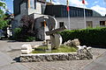
Dragonfly fountain in front of the church

Entering the town from Büsserach

Roundabout at the intersection of the canton roads in the village center

Wydehof high-rise in the center

Parish hall
_katolika_preghejo_689.JPG)
_katolika_preghejo_de_interne_701.JPG)
_puto_antau_la_katolika_preghejo_696.JPG)
_664.JPG)
_682.JPG)
_680.JPG)
_komunuma_domo_707.JPG)
coat of arms
- Split from yellow with a green two-petalled cattail and from red with a white wavy bar
The colors green-yellow correspond to those of the district coat of arms; the colors red and white match those of the canton of Solothurn.
Personalities
- Hermann Dietler (1839–1924), Swiss politician (FDP)
- Urs Rauber (* 1948), journalist and author
- Fridolin Roth (1839–1920), Swiss politician (Catholic Conservative Party)
literature
- Gottlieb Loertscher: The art monuments of the canton of Solothurn, Volume III: The districts of Thal, Thierstein, Dorneck. (= Art Monuments of Switzerland. Volume 38). Edited by the Society for Swiss Art History GSK. Bern 1957, DNB 750089342 .
Web links
- Official website of the municipality of Breitenbach
- Web link to the history of the oldest company in Breitenbach, the Bandfabrik Breitenbach
- Lukas Schenker: Breitenbach. In: Historical Lexicon of Switzerland .
Individual evidence
- ↑ Permanent and non-permanent resident population by year, canton, district, municipality, population type and gender (permanent resident population). In: bfs. admin.ch . Federal Statistical Office (FSO), August 31, 2019, accessed on December 22, 2019 .