
Witterswil
| Witterswil | |
|---|---|
 |
|
| State : |
|
| Canton : |
|
| District : | Dorneck |
| BFS no. : | 2481 |
| Postal code : | 4108 |
| Coordinates : | 606 406 / 259 641 |
| Height : | 338 m above sea level M. |
| Height range : | 323–504 m above sea level M. |
| Area : | 2.67 km² |
| Residents: | 1438 (December 31, 2018) |
| Population density : | 539 inhabitants per km² |
| Website: | www.witterswil.ch |
 View of Witterswil (in the foreground) |
|
| Location of the municipality | |
  |
|
Witterswil (in dialect: Witterschwill ) is a municipality in the district of Dorneck in the canton of Solothurn in Switzerland .
geography
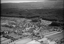
Witterswil lies at 338 m above sea level. M. , 9 km south-southwest of the city of Basel (linear distance). The clustered village extends in an exclave of the canton of Solothurn in a wide hollow at the northern foot of the Jura , in the rear Leimental , near the border with France .
The area of the municipal area of 2.7 km² includes a small section at the northern foot of the Juran. In terms of nature, Witterswil lies in the transition area from the gently undulating landscape of the Sundgau hills to the folded Mesozoic rock layers of the northern Jura. A slight depression begins around the old village center, which opens to the east towards Ettingen and is drained by the Marchbach to the Birsig . The wide ridge of Nassläng and Witterswilerfeld, only 20 m higher, connects to the north of this valley depression . Parallel to this, the Muldental of the Binnbach runs further north , which in turn is flanked by the ridge of the Egg ( 353 m above sea level ; northern municipal boundary).
South of Witterswil the terrain rises steeply over the slope of the Witterswil mountain and reaches at 500 m above sea level. M. the highest point of the municipality. The anticline of Witterswilerstrasse mountain forms one of the blue chain upstream Jura fold . In 2014, 17% of the municipal area was in settlements, 20% in forests and woodlands and 63% in agriculture.
Extensive new residential quarters belong to Witterswil. Neighboring communities of Witterswil are Hofstetten-Flüh and Bättwil in the canton of Solothurn and Biel-Benken , Therwil and Ettingen in the canton of Basel-Landschaft .
population
With 1,438 inhabitants (as of December 31, 2018) Witterswil is one of the medium-sized communities in the canton of Solothurn. 91.6% of the residents speak German, 2.3% French and 2.1% speak Italian (as of 2000). The population of Witterswil was 298 in 1850 and 303 in 1900. In the course of the 20th century the population increased only very slowly to 347 people by 1960. In contrast to the neighboring municipality of Bättwil, the rapid population growth started in the 1960s, which led to a doubling of the population within 10 years (705 inhabitants were counted in 1970). Since then, the trend has continued in a weaker form. Today the settlement area of Witterswil has grown together almost completely with that of Bättwil.
Culture
The Leimentaler Open Air music festival has been taking place every year on the Fahrsportwiese in Witterswil since 2003 . This is one of the largest cultural events in the Basel region. However, this open air was relocated to Oberwil from 2009. Witterswil has a male choir and an organization called “Pro Witterswil”, which regularly organize cultural events.
economy
Witterswil was a predominantly agricultural village until the second half of the 20th century . Today arable farming , fruit growing (mainly cherry trees) and cattle breeding only play a minor role in the income structure of the population. Further jobs are available in local small businesses and in the service sector. Today there are construction, information technology and wood processing companies based in Witterswil. Companies from various industries, including primarily in biotechnology, are rented in the Witterswil Technology Center (TZW AG). In the last few decades the village has developed into a residential community. Most of the employed are therefore commuters who mainly work in the Basel region.
traffic

The community has good transport links. It is located on a connecting road from Aesch (BL) to Flüh . The next connection to the high-speed road H18 (Basel-Delémont) is about 6 km from the town center. By tram line 10 of Baselland Transport AG (BLT), which serves the route from Basel to Rodersdorf , Witterswil is connected to the public transport network - on the nights Fri / Sat and Sat / Sun, however, with the bus line N26 of the night network.
history
The first written mention of the place took place in 1268 under the name Witerswilr ; The name Wittelswilre has been handed down from 1340 . The place name goes back to the Old High German personal name Withari and thus means hamlet / homestead of Withari .
Witterswil was part of the Rotberg rule since the Middle Ages . For a long time this rule had the status of a free imperial fiefdom , which was directly subordinate to the emperor, which is why Witterswil was one of the seven free imperial villages on the Blauen. The Rotberg dominion came to Solothurn through purchase in 1515 and was subsequently assigned to the Dorneck Bailiwick. After the collapse of the Ancien Régime (1798) Witterswil belonged to the Dornach district during the Helvetic Republic and to the Dorneck district from 1803. At the end of the 20th century, the idea of a merger between Witterswil and the neighboring municipality of Bättwil came up, although this was not pursued further for the time being. The Witterswil community assembly put an end to a second attempt in September 2015, when a secret ballot voted 105 no to 69 yes. With 94 yes against 42 no, Bättwil was in favor of a ballot box. Source: Witterswil village newspaper, October 2015.
Attractions
The Church of St. Catherine was built in 1641 on the site of a medieval church and was completely renovated in 1983. Together with Bättwil, Witterswil has formed an independent double parish since 1808. Some characteristic farmhouses from the 17th and 18th centuries have been preserved in the old town center.
coat of arms
- Split by yellow with black bar and red-white division, covered with half a black St. Catherine wheel at the slit.
The coat of arms is a combination of the coat of arms of the Lords of Rotberg and the coat of arms of the canton, evidenced by the attribute of the church patroness. Source: Joseph Melchior Galliker, Schweizer Wappen und Fahnen, Issue 7, p. 42, Zug 2004
literature
- Gottlieb Loertscher: The art monuments of the canton of Solothurn, Volume III: The districts of Thal, Thierstein, Dorneck. (= Art Monuments of Switzerland. Volume 38). Edited by the Society for Swiss Art History GSK. Bern 1957, DNB 750089342 .
- Josef Stebler: The Witterswil airfield (= Witterswil history and stories No. 1). Edited by the community of Witterswil. Witterswil 2013.
- Josef Stebler: Witterswil village names and their origins (= Witterswil history and stories No. 2). Edited by the community of Witterswil. Witterswil 2015.
- Luciano Lippmann: Witterswil boundaries and boundary stones (= Witterswil history and stories No. 3). Edited by the community of Witterswil. Witterswil 2015.
- Josef Stebler: Back then in Witterswil (= Witterswil History and Stories No. 4). Edited by the community of Witterswil. Witterswil 2016.
- Josef Stebler: Witterswil school stories with a chronology 750 years Witterswil 1268-2018 (= Witterswil history and stories No. 5). Edited by the community of Witterswil. Witterswil 2018.
- Josef Stebler: Witterswil - The village in transition (= Witterswil history and stories No. 6). Edited by the community of Witterswil. Witterswil 2019.
Web links
- Official website of the municipality of Witterswil
- Lukas Schenker: Witterswil. In: Historical Lexicon of Switzerland .
Individual evidence
- ↑ Permanent and non-permanent resident population by year, canton, district, municipality, population type and gender (permanent resident population). In: bfs. admin.ch . Federal Statistical Office (FSO), August 31, 2019, accessed on December 22, 2019 .
- ↑ Andres Kristol (Ed.): Lexicon of Swiss community names . Huber, Frauenfeld 2005, ISBN 3-7193-1308-5 , p. 974. There also the first mention of 1268.