
Gempen
| Gempen | |
|---|---|
 |
|
| State : |
|
| Canton : |
|
| District : | Dorneck |
| BFS no. : | 2474 |
| Postal code : | 4145 |
| Coordinates : | 616 668 / 258426 |
| Height : | 676 m above sea level M. |
| Height range : | 556–760 m above sea level M. |
| Area : | 5.99 km² |
| Residents: | 867 (December 31, 2018) |
| Population density : | 145 inhabitants per km² |
| Website: | www.gempen.ch |
 Municipal House (old school from 1834) |
|
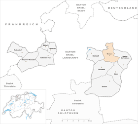
| Location of the municipality | |
  |
|
Gempen (in dialect: Gämpe ) is a municipality in the district of Dorneck in the canton of Solothurn in Switzerland .
population
- Proportion of foreigners: 13.5%
- Religion: 39% Roman Catholic ,? % reformed
geography

The municipality of Gempen is located in the northern tip of the canton of Solothurn, which protrudes here into the canton of Basel-Landschaft. Gempen is located on the Gempen plateau at 676 m above sea level. M., and around 80 meters higher rises the Schartenfluh, visible from afar, called Gempenstollen by many, with the Gempenturm , a 28-meter-high observation tower at 759 m above sea level. M.
- Area: 597 ha , of which 52% was agriculture, 41% forest, 7% settlements in 2014
Neighboring communities in Gempens are, starting from the north: Muttenz BL , Nuglar-St. Pantaleon , Büren , Hochwald , Dornach , Frenkendorf BL , Pratteln BL and Arlesheim BL .
coat of arms
- On a blue background a hand raised in an oath in a red sleeve
history
Gempen (Latin campania, late Latin campus = fields, plain) has a long and important history. Tools made of stone and flint as well as iron have been found in numerous caves . These date back to the Bronze Age and the younger Iron Age (around 500 BC). In Celtic settlements of Rauriker (500-558 v. Chr.) Indicate the grave Hill, known cremations , out.

In Roman times a pass road connected Gempen with Augusta Raurica ( Kaiseraugst ) via the Ramsthal . The Hilzenstein ruins are said to have been a Roman watchtower.
After the Romans, the Alemanni came to this area around 250 and then the Franks , who introduced the county administration, around 496 . The Franconian Augst gau was later divided into Frickgau and Sisgau, and Gempen came to the Sisgau . After various "changes of hands" the Sisgau came to the city of Basel in 1464 . In 1485 Solothurn bought the first half of the Dorneck estate with the village of Gempen. During the Swabian War , in which the village was badly affected by village fires, parts of Gempen were not yet Solothurn. In 1502 Solothurn was able to acquire the other half of Basel with all the rights of high jurisdiction (municipal coat of arms).
Tensions between Basel and Solothurn almost sparked the gallows war in 1531 . Through the mediation of Bern, a contract was concluded between the two cantons, and until the French invasion in 1792 ( French Revolution ), Gempen belonged to the diocese of Basel .
During the Second World War , the area around Gempen played an important strategic role within Switzerland. There was even a "Gempen Division" of the Swiss Army. Several hundred soldiers were stationed on the Gempenplateau during the Second World War . A watch / listening post was located on the Gempenturm to observe the movements of the German and French troops. There should also have been aerial battles over the Gempen. An American bomber was shot and then had to make an emergency landing at Aesch BL.
traffic
There are good road connections from Gempen via Nuglar to Liestal , via Hochwald to Seewen , a winding road down to Dornach . Side streets lead over the Schönmatt down to the Basel landscape communities Arlesheim , Muttenz , Pratteln , Frenkendorf and Liestal.
A post bus line connects the village with Hochwald and with the Dornach-Arlesheim train station, from where there is a connection to trams and trains to Basel and the communities of Birseck .
A well-known hill climb was held on the mountain route from Dornach to Gempen between 1911 and 1920. 2011, the hundredth anniversary was again a mountain race , this time with historical vehicles discharged. The Gempen Memorial was launched for the second time on September 20, 2014.
Attractions
- Gempenstollen / Schartenfluh observation tower
- Monument "The victors of Dornach 1499", in memory of the Battle of Dornach of the Swabian War , outside the village. The monument, created in 1854, depicts a tree trunk from which a sack of oats hangs and a halberd is stuck behind it.


literature
- Gottlieb Loertscher: The art monuments of the canton of Solothurn, Volume III: The districts of Thal, Thierstein, Dorneck. (= Art Monuments of Switzerland. Volume 38). Edited by the Society for Swiss Art History GSK. Bern 1957, DNB 750089342 .
Web links
- Official website of the municipality of Gempen
- Lukas Schenker: Gempen. In: Historical Lexicon of Switzerland .
Individual evidence
- ↑ Permanent and non-permanent resident population by year, canton, district, municipality, population type and gender (permanent resident population). In: bfs. admin.ch . Federal Statistical Office (FSO), August 31, 2019, accessed on December 22, 2019 .