Birsig
| Birsig | ||
|
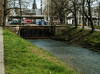
Beginning of the indentation of the Birsig near the zoological garden |
||
| Data | ||
| Water code | FR : A01-0200 , CH : 444 | |
| location |
France
|
|
| River system | Rhine | |
| Drain over | Rhine → North Sea | |
| source | Quellbach from Burg in the municipality of Burg im Leimental and in France in Wolschwiller 47 ° 26 ′ 57 ″ N , 7 ° 25 ′ 44 ″ E |
|
| Source height | 614 m | |
| muzzle | in Basel at the Schifflände in the Rhine Coordinates: 47 ° 33 '37 " N , 7 ° 35' 17" E ; CH1903: 611 252 / 267 735 47 ° 33 '37 " N , 7 ° 35' 17" O |
|
| Mouth height | 245 m | |
| Height difference | 369 m | |
| Bottom slope | 17 ‰ | |
| length | 22 km | |
| Catchment area | 84 km² | |
| Discharge at the Binningen A Eo gauge : 74.5 km² |
NNQ (1987) MNQ 1979–2018 MQ 1979–2018 Mq 1979–2018 MHQ 1979–2018 HHQ (1999) |
2 l / s 410 l / s 830 l / s 11.1 l / (s km²) 1.37 m³ / s 39.2 m³ / s |
The Birsig ( French la Birsig ) is an approximately 20 km long left tributary of the Rhine into which it flows in the middle of the city of Basel . Its catchment area is just over 80 km². The upper course of the Birsig flows alternately on French and Swiss territory. His valley is initially called Leimental . Birsigtal is only called in the lower reaches. It mostly belongs to the Sundgau hills.
The name Birsig is pre-German; one assumes a Celtic Bersikos . The river name Birsig is related to the name of the nearby Birs . This is considered to be old European with the meaning of the fast . Birsig can be understood as a tributary of the Birs or little Birs .
course
The Birsig has two source streams. One source stream comes from Wolschwiller ( German Wolschweiler ) in Alsace, France. Its source is in the Oberfeld near Wolschwiller at an altitude of 470 m. It is called Birsigbrunnen in registers of goods from the 15th and 16th centuries. In the municipality of Biederthal the river flows through the Birsimatt or Bersimatt and is therefore also called Birsigraben or, incorrectly, Börsegraben.
In Switzerland today it is widely assumed that the Birsig rises on the northern slope of the Remels at the foot of the Galgenfels in the municipality of Burg (Canton Basel-Landschaft). The Remel is part of the northernmost Jura range. This spring is at an altitude of 650 m.
The two source brooks unite at the border between the French Biederthal and the Swiss Rodersdorf at point 375. It is certain that the name Birsig will apply from then on; so it is also on the Swiss and French maps. The most important later tributaries are the Binnbach von Flüh and the Marchbach von Witterswil.
Finally, in the city of Basel , the Birsig flows into the Rhine at the Schifflände at an altitude of 244 m . It is the uppermost tributary of the Upper Rhine , which begins shortly before at the Mittlere Brücke , and next to the meadow one of the two Upper Rhine tributaries on Swiss territory.
History and description
In the municipalities of Oberwil, Bottmingen and Binningen close to the city, the Birsig flows openly, but it is straightened and built. In the area of the city of Basel it flows first through the zoological garden and through the nightingale grove. Today it is covered in the city center and old town. In the past, the rows of houses were built directly on the course of the river and numerous bridges and vaults spanned it. He took the sewage and faeces from the steps of the adjoining houses as well as discharges from the surrounding quarters. Because of this, there were cholera and typhus epidemics in the 19th century.
Since the Middle Ages, the Rümelinbach has been an artificially created commercial canal, forming a branch of the Birsig . Today its water feeds the streams and ponds in the zoological garden.
For the pond castles in Benken, Bottmingen and Binningen, the pond water is derived from the Birsig.
bridges
See also list of bridge constructions in Basel
Several small footbridges run over the Birsig in the French estuary; the top so-called “Birsigbrücke” is located in Rodersdorf at 360 m along Oltingerstrasse, further down there are further road bridges and footbridges in Biel-Benken, Oberwil, Bottmingen and Binningen. The three most important bridges are in the urban area of Basel: the Dorenbach Viaduct , the Birsig Viaduct and the Heuwaage Viaduct . Numerous other footbridges and bridges in the city center were demolished in the Middle Ages or integrated into the building fabric of the underground river tunnel at the latest when it was dipped in the 20th century.
literature
- Eduard Golder: The Birsig and its tributaries. Building Department Basel 1995.
- Paul Koelner : The Birsig in Basel's history and cityscape. Basel 1930.
- Eugen A. Meier : Basel then and now (p. 46/47). Basel 1993.
- Baselbieter Heimatblätter: 2018 No. 1 (on Birsig pp. 28–31)
Web links
- The Birsig in old Basel
- Boersegraben near SANDRE (French)
- Birsig on the ETHorama platform
Individual evidence
- ↑ a b c Geoserver of the Swiss Federal Administration ( information )
- ↑ catchment area. In: Topographical catchment areas of Swiss waters: sub-catchment areas 2km2. Retrieved May 30, 2019 .
- ↑ Birsig. (PDF) Position 4311: monthly samples. In: Canton Basel-Landschaft civil engineering office, hydraulic engineering division. Retrieved May 30, 2019 .
