
Birs


| ||
Location of the source and mouth of the Birs |
The Birs ( French La Birse ) is a 75 kilometer long tributary of the Rhine in the Swiss Jura .
geography
source
The Birs rises from a spring at a height of 762 meters a little southwest of Tavannes in the Bernese Jura below the Pierre Pertuis . It already appears as a small river ( power source ), because the large amount of water comes from an underground river system. The rainwater collects deep inside the mountain and flows through an extensive, kilometer-long network of caves. It is the largest spring in the whole valley and has its source as a karst spring in the Upper Jura . In the years 1974–1976 the mean discharge from the spring was around 20 m³ / min.
course
The Birs flows through wide valleys ( Vallee de Tavannes ) and narrow, framed by high walls Klusen (canyons), for example in Moutier the gorges de Moutier . At Delémont (Delsberg), the capital of the Jura canton , it joins the two streams La Sorne and La Scheulte . Between Soyhières and Liesberg she switches from French to German-speaking region and reached the the canton of Basel-Land belonging Laufental . In Laufen , when crossing a resilient limestone bank , it forms a waterfall a good 2 meters (with a weir over 3 meters) high , whose water power was one of the starting points for the commercial development of the city.
At the Klus Angenstein the river crosses the Blauenkette and reaches the Birseck , the lowlands near Aesch . Between Aesch and Dornach numerous crabs can be found in the Birs , whereby the red American crayfish represents a danger for the native cancer types due to its aggressive behavior and threatens to displace them increasingly. The upper reaches of the Birs belong to the trout region , the lower reaches into the grayling region . In the past, the Birs was heavily polluted and dammed by people and industry, but thanks to numerous renaturation projects, a diverse flora and fauna thrives today.
The Birs crosses eight mountain ranges in differently pronounced gaps. After the Klus Angenstein, depending on the amount of water, the river could expand strongly and make its way. Therefore, attempts were made early on to force the river into a tight corset. Before the Jura Railway was built, the river was straightened and partially dammed in 1875. In this way, dry pasture and building land was obtained and safe crossings could be built for the growing traffic. Only the dense alluvial forest near the heath in Reinach BL remained. The Reinacherheide is a nature reserve with poor grasslands , dry bushes and the alluvial forest. It is a true bird paradise with 83 different bird species.
The Birs plain was hardly populated until the end of the 18th century. Where the river once sought its way to the Rhine in many arms, modern settlement and industrial areas of Arlesheim , Reinach BL and Münchenstein are spreading today . The lower course of the Birs forms the border between the two cantons of Basel-Stadt and Basel-Landschaft . A previously straightened section of the river was turned back into a natural river bed in 2004. Since then, the beaver has spread again in this area. Forming the city limits of Basel and Birsfelden , the Birs flows into the Upper Rhine at Birskopf after 75 kilometers at only 246 meters above sea level .
Catchment area
The catchment area of the Birs covers 896.86 km² and is mainly in Switzerland, with smaller areas in France. In Switzerland, the five cantons of Bern , Jura , Solothurn , Basel-Landschaft and Basel-Stadt have a share. It extends over two language regions (French and German). Important neighboring catchment areas are those of Birsig , Ill , Rhone , Dünnern and Ergolz .
Tributaries
Important tributaries of the Birs are La Trame , Ruisseau de Chaluet, La Challère, La Raus , La Scheulte , La Sorne , Ruisseau de Mettembert, Lützel , Wahlenbach , Lüssel , Ibach , Chastelbach, Schlossgrabenbach , Seebach and Tugbach .
bridges
On its way the Birs is spanned by over 200 bridges.
Stone arch bridges worth preserving are in Pontenet (Pont Sapin), Mallerey (Rue du Pont Bridge), Sorvilier (La Golée Bridge), Laufen (suburban bridge), Zwingen ( Ramstein Bridge ) , Duggingen ( Birs Bridge Angenstein ) and Dornach ( Nepomuk Bridge ).
Four covered wooden bridges span the river, with the Zwingen Castle Bridge being the only preserved historical wooden bridge in the Birstal valley.
Nineteen railway bridges span the Birs, with the Jura Railway between Moutier and Münchenstein crossing the river on eight bridges.
At the former cement factory in Liesberg, Robert Maillart's railway bridge from 1935 is listed in the cantonal inventory of protected cultural monuments.
Picture gallery
- The Birs

Mill at the source of the Birs (1802)

Upper course of the Birs near Tavannes

The Birs at Sorvilier

Waterfall ( Laufen ) of the Birs in Laufen

Birswehr in the New World , Münchenstein
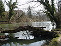
Lower course of the Birs

Birs estuary into the Rhine

Birs in Dornach with hydroelectric power station


literature
- René Salathé: The Birs. Pictures of a river landscape , Verlag des Kantons Basel-Landschaft, 2000, ISBN 3-85673-260-8
Web links
- Hydrological data of the Birs
- François Kohler: Birs. In: Historical Lexicon of Switzerland .
- The Birs: Regional drainage plan REP
Individual evidence
- ↑ a b Geoserver of the Swiss Federal Administration ( information )
- ↑ a b Explanations of the Hydrogeological Map of Switzerland
- ↑ Evaluations of the water network. (XLSX) FOEN , December 2013, accessed on August 9, 2017 (listing of Swiss rivers> 30km).
- ↑ Topographical catchment areas of Swiss waters: sub-catchment areas 2 km². Retrieved September 24, 2017 .
- ↑ Measuring station Münchenstein, Hofmatt 2016 (PDF) Federal Office for the Environment FOEN
- ^ René Salathé 2000: The Birs. Pictures of a river landscape, page 13
- ^ Federal authorities of the Swiss Confederation: swisstopo (topography and factual data) ; accessed on June 15, 2016
- ↑ Giuseppe Gerster 1994: Baselbieter Heimatschutz, Issue 15 Cultural and Architectural Monuments in Laufental, page 53.
Rivers with a total length of more than 30 km:
Aare |
Albula |
Allaine |
Old Rhine |
Arbogne |
Areuse |
Swiss stone pine |
Birs |
Brenno |
Broye |
Calancasca |
Doubs |
Drance de Bagnes |
Thinning |
Emme |
Engelberger Aa |
Ergolz |
Glâne |
Smooth |
Glenner (Glogn) |
Hinterrhein |
Inn (En) |
Julia (Gelgia) |
Kander |
Little Emme |
Landquart |
Land water |
Langete |
Limmat |
Linth |
Lorze |
Maggia |
Mentue |
Moësa |
Muota |
Murg |
Necker |
Orbe |
Petite Glâne |
Plessur |
Rabiusa |
Reuss |
Rhine |
Rhone |
Saane |
Schüss (Suze) |
Seez |
Scythe |
Sihl |
Simme |
Sitter |
Sorne |
Suhre |
Talent |
Tamina |
Ticino (Ticino) |
Thur |
Töss |
Venoge |
Verzasca |
Vispa |
Vorderrhein |
Wigger |
Wyna