
Saane


| ||
Source and mouth of the Saane
|
The Saane (French Sarine , Friborg Patois ) is a 126 km long river in Switzerland .
course
The Saane rises as La Sarine on the Sanetschhorn above Gsteig in the canton of Bern and near the Col du Sénin , flows northwards to Gstaad and on to the municipality of Saanen , which was named after the river. It then flows west through the Pays d'Enhaut before turning north again at Montbovon and running into the valley known as Intyamon in the Haute Gruyère region . At the end of this, it flows into the Gruyère lake (a reservoir ), continues north to Freiburg and then flows northeast into the Schiffenensee (also a reservoir) until it flows into the Aare west of Bern .
Around 150 years ago, the Saane flowed largely wildly within Molasse gorges and crossed numerous floodplain areas. In order to gain land for agriculture and to improve protection against flooding, it was channeled. In addition, six dams were built to use the hydropower.
The river is often equated with the so-called Röstigraben , the language border between German and French-speaking Switzerland .
Known structures that cross the Saane are the Grandfey viaduct to the railway line Lausanne-Bern , the Poya Bridge in Freiburg, which relieves the Burg quarters of through traffic and the Saane viaduct to the railway line Bern-Neuenburg at Gümmenen .
Between Rossens and Freiburg, the Saane flows through a very diverse landscape with a kind of canyon with Molasse gorges and floodplains. In front of the city of Freiburg, it accumulates in the nature reserve of Lake Perolles . This reservoir was created by the construction of the Magerau Dam in 1872. The concrete dam was the first of its kind in Europe. Below it, the Saane flows in its meander around the Freiburg lower town. Soon afterwards the Schiffenensee follows as the last reservoir. Before the construction of the various reservoirs, there were salmon migrations that could be observed until the beginning of the 20th century.

The Saane near Freiburg
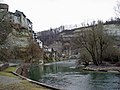
The Saane avoids Freiburg's old town

The Saane near Freiburg
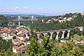
Poya and Zähringer bridges as seen from the Loreto Chapel in Freiburg / Switzerland


Water pollution
The La Pila landfill , located a little outside the city of Friborg in the municipality of Hauterive , was used for disposal from 1952 to 1973 and is today one of the six largest contaminated sites in Switzerland. Because PCB flows into the Saane, the landfill is to be renovated from 2022.
Individual evidence
- ↑ a b Geoserver of the Swiss Federal Administration ( information )
- ↑ Evaluations of the water network. (XLSX) FOEN , December 2013, accessed on August 9, 2017 (listing of Swiss rivers> 30km).
- ↑ Topographical catchment areas of Swiss waters: sub-catchment areas 2 km². Retrieved July 22, 2018 .
- ^ Sarine - Broc, Château d'en bas. (PDF) In: Federal Office for the Environment. Retrieved July 23, 2018 .
- ^ Sarine - Friborg. (PDF) In: Federal Office for the Environment. Retrieved July 23, 2018 .
- ↑ Saane - Laupen. (PDF) In: Federal Office for the Environment. Retrieved July 23, 2018 .
- ^ Pascal Mulattieri and Claudia Zaugg: Saane . In: Susanna Muhar, Andreas Muhar, Gregory Egger, Dominik Siegrist (eds.): Rivers of the Alps. Diversity in nature and culture . Paul Haupt, Bern 2019, ISBN 978-3-258-08114-4 , pp. 460-461 .
- ^ Pascal Mulattieri and Claudia Zaugg: Saane . In: Susanna Muhar, Andreas Muhar, Gregory Egger, Dominik Siegrist (eds.): Rivers of the Alps. Diversity in nature and culture . Paul Haupt, Bern 2019, ISBN 978-3-258-08114-4 , pp. 460-461 .
- ^ Freiburg's contaminated sites - government proposes a variant for the rehabilitation of the La Pila landfill. In: srf.ch . February 15, 2019, accessed August 20, 2019 .
- ↑ Four variants for the rehabilitation of the former La Pila landfill in the area of the municipality of Hauterive (FR). In: fr.ch . February 15, 2019, accessed March 24, 2020 .
Web links
Rivers with a total length of more than 30 km:
Aare |
Albula |
Allaine |
Old Rhine |
Arbogne |
Areuse |
Swiss stone pine |
Birs |
Brenno |
Broye |
Calancasca |
Doubs |
Drance de Bagnes |
Thinning |
Emme |
Engelberger Aa |
Ergolz |
Glâne |
Smooth |
Glenner (Glogn) |
Hinterrhein |
Inn (En) |
Julia (Gelgia) |
Kander |
Little Emme |
Landquart |
Land water |
Langete |
Limmat |
Linth |
Lorze |
Maggia |
Mentue |
Moësa |
Muota |
Murg |
Necker |
Orbe |
Petite Glâne |
Plessur |
Rabiusa |
Reuss |
Rhine |
Rhone |
Saane |
Schüss (Suze) |
Seez |
Scythe |
Sihl |
Simme |
Sitter |
Sorne |
Suhre |
Talent |
Tamina |
Ticino (Ticino) |
Thur |
Töss |
Venoge |
Verzasca |
Vispa |
Vorderrhein |
Wigger |
Wyna