
Montbovon
| Montbovon | ||
|---|---|---|
 |
||
| State : |
|
|
| Canton : |
|
|
| District : | Gruyère | |
| Municipality : | Haut-Intyamon | |
| Postal code : | 1669 | |
| former BFS no. : | 2121 | |
| Coordinates : | 568 877 / 148082 | |
| Height : | 797 m above sea level M. | |
| Residents: | 265 (2004) | |
| Website: | www.montbovon.ch | |
| map | ||
|
||


Montbovon ( Friborg Patois ) is a town in the French part of the canton of Friborg in Switzerland . The formerly independent political municipality merged on January 1, 2002 together with Albeuve , Neirivue , and Lessoc to form the new municipality of Haut-Intyamon in the Gruyères district , whose municipal administration is located in Albeuve. The former German name Bubenberg is no longer used today.
history

Montbovon, located on the southern tip of the canton of Friborg, borders the Pays d'Enhaut. The place Montbovon, whose name was changed several times, appears for the first time in the middle of the 13th century in documents in 1255. The place name was subject to multiple changes from Montbovonis to Montisbovonis, Monbovon, Mons Bovum, Mons Bovarium and Mont Bovon. However, it is likely that its origin is Mont de Bovon, named after the name of a Gruyère family from the 12th century. The name Bovo comes from the Germanic Bôban and means young boy . The German name Montbovons used to be Bubenberg or Boemberg until 1492 .
The community was initially subject to the Duchy of Gruyères, became Friborg after its division and, after the abolition of the Vogtei, became part of the district of Gruyères . The first village was built above the Saane rocks, at the site of today's sawmill. After a plague epidemic, some of the houses were burned down to prevent the disease from spreading. The village was later rebuilt at its current location. The original connection between the Gessenay (Saanenland), the Pays d'Enhaut and the shores of Lake Geneva was via the Montbovon - Allières - Col de Jaman - Lake Geneva pass crossing . For several centuries, mule and horse caravans with merchandise moved through Montbovon.
The residents of Montbovon were first attached to the church district of Broc, then until 1621, the parish of Albeuve. They built two churches and three chapels within five centuries: the first chapel dedicated to Saint Grat in 1515, the first church in 1621, the Saint Marie - Madeleine chapel in Allières in 1721, today's church in 1897 and finally the Oratorium de la Gaulaz , a small chapel in 1941 in honor of Notre Dame de la Paix. In February 1990, a landslide destroyed the chapel in Allières. This was rebuilt in 1996. In 2002, after the merger of the four municipalities of Montbovon, Lessoc , Neirivue and Albeuve, the new municipality of Haut-Intyamon was created .
geography
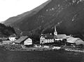
Montbovon around 1890
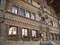
Ancienne Auberge de la Croix Blanche

Eglise St. Grat

school

railway station

Route du Village

Chemin de Coro d'oro


Montbovon, located in a mountain zone, has little level ground despite its approx. 19.8 km² area (13th among the Freiburg municipalities). Approx. 14 km² of meadow and pasture land, about 2.5 km² of forest and 3.2 km² of barren soil make up the total surface area. The barren, thin-layered soil, which often protrudes rocks, is not suitable for arable farming. The climate is extremely rough, especially in winter and with the Ruhlyio wind (local south wind). The favorable geographical location enables the best connections by road and rail with the Gruyère region, the Pays-d'Enhaut and the Montreux region.
At the end of the Intyamon valley, nestled between the Lac de Lessoc and the foot of the Corjon pyramid, lies the town of Montbovon. The small village, north of a mountain range, is at the exit of the La Tine bottleneck.
Infrastructure
The official buildings include the church, the schoolhouse, two chapels, a hotel, a cheese dairy, a grocery store, and four train stations. The houses were not built in alignment. The architectural style is mostly about concrete structures up to medium height with wood being used as the upper part material. Several houses were built in chalet style and mostly with browned wood. At clubs and associations there is a brass band, a mixed choir, the shooting club, tourist association, ski club, the young team, the milk association and the cattle breeders association.
population
| Population development | |
|---|---|
| year | Residents |
| 1850 | 387 |
| 1900 | 611 |
| 1910 | 516 |
| 1920 | 544 |
| 1930 | 537 |
| 1940 | 534 |
| 1950 | 483 |
| 1960 | 338 |
| 1970 | 300 |
| 1980 | 283 |
| 1990 | 265 |
| 1997 | 250 |
| 2005 | 260 |
languages
Religions - denominations
economy
For the formerly exclusively agricultural population, the construction of the power station at the end of the last century brought new income opportunities. The construction of the railway, the construction of the MOB tunnel and the electric Gruyère railway at the beginning of the 20th century expanded the labor supply. Several buildings were constructed: the four train stations (Montbovon - Les Sciernes Allières - Les Cases), the electrical substation of the MOB, the workshop warehouse of the MOB, the two hotels, the schoolhouse, the bakery, the dairy and the slaughterhouse. The large building in the north of the village became the branch of various industries over the years: a foundry, a calcium carbide factory, a metallurgy (chrome steel), a tannery, a lacquer factory and a factory for gaming table covers, all of which however did not exist. Since the end of the Second World War in 1945 and due to the lack of jobs, the number of inhabitants has steadily decreased. The initially hesitant decline became more and more significant over the years. Small farmers had to give up their business because it was no longer viable. Of the more than 40 milk producers Montbovon counted around 1940, 13 remained.
During the second half of this century, the construction of mountain roads such as Les Pichons - La Cuvigne - la Boveresse; Allières - Orgevaux, the connection Montbovon - Allières Hongrin - Col des Mosses dam, as well as the entire drinking water supply for the hamlets and in Allières.
traffic

Montbovon is on the Montreux – Berner Oberland Railway (MOB) route, which runs from Montreux on Lake Geneva via Les Avants, Montbovon, Rossinière, Château-d'Œx, Rougemont, Saanen, Gstaad and Zweisimmen to Lenk. In addition, Montbovon is connected to the route network of the Freiburg Transport Authority (TPF).
Attractions
- There are several old buildings from the 16th and 17th centuries, especially in the hamlets.
- The old hostel Zum weissen Kreuz , also known as Le Vieux Châlet , was built in 1725 by Antoine Jordan. It is a rare example of a chalet in the Pays d'Enhaut.
- The Saint Grat church, built in 1897, was restored in 1995 in the neo-Romanesque art style .
Personalities
- Dominique Martinetti (born April 15, 1739 in Peccia ; † May 2, 1808 in Freiburg im Üechtland ), wood sculptor active in Freiburg and Montbovon
Web links
- Marianne Rolle: Montbovon. In: Historical Lexicon of Switzerland .
- Website of the locality of Montbovon-Allières
Individual evidence
- ↑ Dominique Martinetti. In: Sikart , accessed January 20, 2016.
Bas-Intyamon | Botterens | Broc | Bull | Châtel-sur-Montsalvens | Corbières | Crésuz | Echarlens | Grandvillard | Gruyères | Hauteville | Haut-Intyamon | Jaun | La Roche | Le Pâquier | Marsens | Morlon | Pont-en-Ogoz | Pont-la-Ville | Riaz | Sâles | Sorens | Val-de-Charmey | Vaulruz | Vuadens
Former municipalities: Albeuve | Avry-devant-Pont | Cerniat | Charmey | Enney | Estavannens | Gumefens | La Tour-de-Trême | Le Bry | Lessoc | Maules | Montbovon | Neirivue | Romance | Rueyres-Treyfayes | Villarbeney | Villars-d'Avry | Villars-sous-Mont | Villarvolard | Vuippens
Canton of Friborg | Districts of the canton of Friborg | Municipalities of the canton of Friborg