
Bull FR
| FR is the abbreviation for the canton of Friborg in Switzerland and is used to avoid confusion with other entries of the name Bulle . |
| Cop | |
|---|---|
 |
|
| State : |
|
| Canton : |
|
| District : | Gruyère |
| BFS no. : | 2125 |
| Postal code : | 1630 Bulle 1635 La Tour-de-Trême |
| UN / LOCODE : | CH BUL |
| Coordinates : | 570 848 / 162987 |
| Height : | 771 m above sea level M. |
| Height range : | 674–1389 m above sea level M. |
| Area : | 23.86 km² |
| Residents: | 23,439 (December 31, 2018) |
| Population density : | 982 inhabitants per km² |
| Website: | www.bulle.ch |
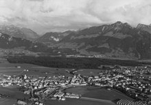
 View of Bulle from Gruyères Castle |
|
| Location of the municipality | |
  |
|

Bulle ([ byl ]; Freiburger Patois ) is a municipality in the French-speaking part of the canton of Friborg in Switzerland . The city is located in the Gruyère district west of Lake Gruyère . Bulle is the second largest city in the canton of Friborg and an important regional economic and trade center in the southern part of the canton. The German name Boll is rarely used today.
On January 1, 2006, La Tour-de-Trême was incorporated into Bulle.
geography
Bulle lies at 771 m above sea level. M. , 23 km south-south-west of the canton capital Freiburg (linear distance). The city extends on the plain north of the Trême mountain stream , sloping slightly to the east , in the wide basin of Bulle in the Gruyère region, at the northern foot of the Moléson massif . A few kilometers east of the city lies the Gruyère lake , through which the Saane (French: Sarine) flows.
The area of the 23.8 km², heavily branched municipal area includes a section of the Bulle basin in the foothills of the Friborg Alps . The main part of the area is occupied by the plain at Bulle, through which the Trême flows. In the east, the area extends to the Saane just above its confluence with Lake Gruyère and includes the extensive forest area of the Bois de Bouleyres , in the northeast it extends to the forest hill Vaucens ( 831 m above sea level ). To the north, the municipality extends over the valley of the Sionge and includes part of the southern slope of Mont de Riaz , which belongs to the Gibloux range .
In a narrow strip, the communal soil extends to the southwest over the hill between the Russon brook and the Trême to the northeast roof of the Les Alpettes forest (up to 1180 m above sea level ). The eastern border is always formed by the Trême cut into the flysch layers of the pre-Alps with an erosion valley. Another narrow tip extends south to the northern foothills of the Moléson. At the height above the Alp Les Maulatreys is 1384 m above sea level. M. reached the highest point of Bulle. In 1997, 17% of the municipal area was in settlements, 31% in forests and woodlands, 51% in agriculture and around 1% was unproductive land.
Bulle includes the village and formerly independent municipality of La Tour-de-Trême , several commercial and residential estates on the outskirts as well as numerous individual farms. Neighboring municipalities to Bulle are Riaz , Echarlens , Morlon , Broc , Gruyère , Le Pâquier (FR) and Vuadens .
population
| Population development | |
|---|---|
| year | Residents |
| 1811 | 1165 |
| 1850 | 1833 |
| 1900 | 3330 |
| 1910 | 4035 |
| 1930 | 4110 |
| 1950 | 5255 |
| 1960 | 5983 |
| 1970 | 7556 |
| 1980 | 7595 |
| 1990 | 9062 |
| 2000 | 11,149 |
| 2005 | 16,041 1) |
| 2010 | 18,947 |
| 1) including La Tour-de-Trême | |
With 23,439 inhabitants (as of December 31, 2018), Bulle is the second largest municipality in the canton of Friborg. 85.5% of the residents speak French, 4.5% speak Portuguese and 3.0% speak German (as of 2000). The population of Bulle was 3330 in 1900. The population growth reflects the industrial and economic development of the city. Significant population increases were observed especially around 1900 and around the middle of the 20th century, while the crisis of the 1970s resulted in zero growth during that decade. Since 1980 (continuous opening of the Bern-Vevey motorway), Bulle has recorded one of the strongest growth rates in municipalities of its size in Switzerland. In 1995 the limit of 10,000 inhabitants was exceeded. The settlement area of Bulle has now seamlessly merged with that of La Tour-de-Trême (south of the Trême stream). With the incorporation of La Tour-de-Trême, another significant increase in population was registered.
politics
legislative branch
The legislative authority is the general council ( conseil général ) elected every five years by the voters of the municipality of Bulle . The 50 MPs are elected by proportional representation. The tasks of the General Council include budget and invoice approval, the establishment of municipal regulations and control of the executive. The graphic on the right shows the composition of the General Council after the elections on February 28, 2016.
executive
The executing authority is the municipal council ( conseil communal ). It consists of nine members and is elected by the people using proportional representation. The term of office is five years. The municipal council is responsible for the enforcement of the resolutions of the general council, for the implementation of federal and cantonal legislation as well as for the representation and management of the municipality. Mayor ( syndic ) is Yves Menoud (CVP, as of 2015).
National Council elections
In the Swiss parliamentary elections in 2019, Bulle's share of the vote was : SP 24.9%, FDP 22.0%, CVP 16.7%, SVP 15.3%, Greens 11.5%, GLP 4.4%, CSP 1, 8%, target for 2030 1.6%.
economy
Bulle has always been an agrarian town. The agricultural products of the surrounding area were processed and sold here. The trade in wood, cheese (especially Gruyère cheese ) and straw wicker was important. Annual and livestock markets have been held for many centuries. In the first half of the 20th century, the industry was mainly focused on wood processing, including sawmills, carpenters, furniture factories and box factories. Industry diversification did not begin until after 1950.
Today, as the economic center of the Gruyère region, Bulle offers around 9,000 jobs. With 2% of the gainfully employed who are still employed in the primary sector, agriculture only has a marginal role in the employment structure of the population. Around 36% of the workforce is employed in the industrial sector, while the service sector accounts for 62% of the workforce (as of 2001).
Agriculture is still mainly represented in Bulle by dairy farming and cattle breeding , arable farming is of little importance . The forests are used for forestry .
Since the 1980s, large industrial and commercial zones, including those of Planchy and Palud, have emerged along the roads on the western, northern and eastern outskirts of the city. The secondary sector is now represented by the construction and transport industry ( Liebherr ), metal construction, mechanical workshops, the food industry (cheese and chocolate), plastics and wood processing as well as the pharmaceutical, chemical and textile industries. From 1976 until the bankruptcy in 2017, the fashion chain Yendi is based in Bulle.
Bulle is the seat of the city and district administration, location of various banks, insurance companies, engineering, architecture and trustee offices. There are other jobs in the catering industry, in the numerous boutiques and shops in the city as well as in handicrafts (wood carving and ceramics). Large shops were built on the outskirts. The district hospital founded in Bulle in 1873 was relocated to Riaz in 1884 .
Education and sport
As a regional center, Bulle has all school levels from primary school to grammar school. The strong growth in the Gruyère region made it necessary to expand the school system over the past few decades; the high school (Collège du Sud) was only opened in 1994. In addition, there has been a vocational school (Ecole professionnelle du Sud du Canton) since 1998, as well as a hotel management school and several private and special schools.
Bulle is also well equipped with regard to sports infrastructure. It has a large sports center with football and tennis courts, a skate park, an ice rink and a heated outdoor pool.
Culture and tourism
Bulle is the urban center of the Gruyère region's tourist region. The old town with the castle and the Musée Gruérien, which has been showing a modern collection of handicrafts and cultural goods from the region since it was rebuilt in 1978, are worth seeing. The historic town of Gruyères , Lake Gruyère and the Moléson excursion mountain are all in the vicinity . The region around Bulle is geared towards both summer and winter tourism. The city also offers the Espace Gruyère (opened in 1998), an event center for cattle shows and markets, as well as for sporting and cultural events. The latter include the Marché Folklorique (every Thursday in July and August), the Christmas market, Carnival and various other festivities. Bulle also has a cinema, a theater and a city library.
traffic
The city of Bulle is an important traffic junction in the south of the canton of Friborg. It is located on the main road 12 from Freiburg to Vevey and also forms the gateway to the Haute-Gruyère and Pays-d'Enhaut , as well as to the Jauntal. In the 1960s, the city fought for the A12 motorway to run through the Gruyère region. This traffic axis, which crosses the municipality, has been open continuously from Bern to Vevey since 1981 and was the only motorway connection from Bern to western Switzerland for around 20 years, led to the region's enormous economic boom since the 1980s. The nearest connection is around 3 km from the city center. As the gateway to the tourism region of the Freiburg Alps, Bulle had heavy through traffic, especially during the weekends. Therefore a bypass (H189) has been built for Bulle and La Tour-de-Trême, which today effectively relieves the city of transit traffic.
In the middle of the 19th century, the city also campaigned for the management of the Lausanne - Bern railway line across the municipality. However, she did not get through with her request and therefore raised a significant amount of money for a rail connection to Romont . On July 1, 1868, the city was connected to the railway network with the opening of the Romont-Bulle line. On July 14, 1904, the Bulle-Vuadens section of the route to Châtel-Saint-Denis and on September 21, 1904, the Bulle-La Tour-de-Trême section of the route to Montbovon followed as further railway lines . The opening of the railway line from Bulle to Broc took place on June 24, 1912.
Several bus routes operated by the Transports publics fribourgeois (TPF) ensure that the public transport is finely distributed . These lead from Bulle to Freiburg (as an express bus via the A12 and as a normal route via Le Bry or La Roche ), Boltigen , Corbières , Grandvillard , Morlon and Moléson-Village. The new bus station was completed in 1992. The TPF also run two city lines in Bulle: Line 1 (Riaz – La Tour) and Line 2 (Morlon – Vuadens)
history
The municipality of Bulle was settled before the turn of the century. The oldest evidence of human presence is a burial mound from the Hallstatt period . It is very likely that a settlement also existed during Roman times , but there are hardly any remains of it.
The first written mention of the place dates back to 852 under the name Butulo - latinized Bulium . The names Bulo (859), Butulum (867), Bollo (around 1200), Bullo and Bullos (1225) appeared later . The place name is probably derived from the French word butte (meaning mound of earth).
The origins of today's bull are largely in the dark. The core of the settlement was probably the church of Saint-Eusèbe, founded by the bishop of Lausanne in the 6th or 7th century, which was the mother church of the Gruyère region and, until the foundation of the Gruyères parish in the 13th century, it served as the parish church of the entire Saan valley of La Roche in the north to Montbovon in the south. The area of Bulle has therefore belonged to the Bishop of Lausanne since the 6th century and, along with Avenches and Curtilles, was one of the oldest areas directly subordinate to the Bishop.
Later, the ancestors of the Counts of Gruyères also seem to have owned the settlement. After the counts had settled on the hill of Gruyères (5 km from Bulle), founded the town of Gruyères and quickly expanded their position of power in the region with the county of Gruyères , there were numerous disputes between the bishop from the early 12th century and the count. As a result of one of these conflicts, Bulle came back into the sole possession of the bishops of Lausanne after 1190. They also abolished the Gruyère market in 1196 and expanded the older market in Bulle instead.
From 1231 the previously small market town was expanded into a town with defensive walls and a castle at the instigation of the bishops. Although there is no actual document conferring city rights, the citizens gradually received freedoms and rights similar to those of the city of Lausanne. The bishops were represented in Bulle by a Kastlan and a Meier, the post of Meier being reserved for the noble family of the Lords of Bulle until the 15th century.
In contrast to other cities in the region, Bulle experienced a further economic boom after 1350 due to its location on the trade route from Vevey to Freiburg and Bern, which was hardly affected even by the city fire in 1447. In the course of the Burgundian Wars , the city signed a castle rights treaty with Freiburg in 1476, which spared it from the confederates' raids.
When the Bernese conquered Vaud in 1536 and the Bishop of Lausanne had to flee, Bulle placed himself under the protection of the city of Friborg. However, this protection soon turned out to be rulership, because Freiburg appropriated the episcopal lands and established the Bailiwick of Bulle in 1537 , to which, in addition to the city of Bulle and the village of Riaz, the exclaves Albeuve and La Roche with Pont-la-Ville belonged. In the period that followed until 1798, 54 bailiffs resided at Bulle Castle.

In the 17th and 18th centuries, the statue of the Virgin Mary Notre-Dame de Pitié (also Notre-Dame de Compassion) in the hospital chapel became an important pilgrimage destination, which also attracted pilgrims from Savoy and the Free County of Burgundy . Otherwise, Bulle lived from trading in cattle and cheese wheels.
In 1798 the townspeople welcomed the arrival of the French troops. As early as January 26, 1798, the tree of freedom was erected and the governor was chased out of the city. Bulle would now have liked to join the Lemanic Republic , but had to stay with Freiburg. It became the capital of the newly founded Bulle district, which included the parts of the Gruyère region west of the Saane and north of the Trême. With the reorganization of the districts as part of the Freiburg cantonal constitution of 1848, the Bulle district was incorporated into the Gruyère district. Bulle was chosen as the capital of the new Gruyère district.
On April 2, 1805, almost the entire city was cremated in a conflagration. During the reconstruction, the cityscape was decisively changed: Several rows of houses were not rebuilt in favor of a large market square. The gates and walls were demolished in the 1830s.
At the beginning of the 19th century, Bulle developed into the center of opposition to the conservative cantonal government. The city has been the scene of politically motivated conflicts several times. Bulle experienced a significant economic boom after it was connected to the Swiss railway network in 1868 when the line from Romont to Bulle was opened.
As part of the community mergers funded by the canton of Friborg since 2000, the formerly independent community of La Tour-de-Trême was incorporated into Bulle with effect from January 1, 2006.
Attractions

Bulle has a picturesque townscape, the town houses mainly dating from the early 19th century (after the town fire of 1805). The rectangular city plan shows an area of around 400 m × 150 m and has two parallel main streets and several small cross streets, with the castle forming the southern end and the city church the northern end. Hardly anything has been preserved from the former city fortifications.
The Bulle Castle was built in the 13th century under the Bishops of Lausanne based on the Carré Savoyard. Its south-east corner is protected by an imposing round donjon with a height of 33 m, a diameter of 13.5 m and a 2.2 m thick wall, while at the other three corners the towers are placed on the curtain wall like echauguettes . The castle only underwent minor changes over the years, for example in the 16th century under the Friborg bailiffs. It now serves as the administrative center of the Gruyère district.
The core of the parish church probably goes back to the 7th century; it has been mentioned since the 9th century. It was destroyed by flames in 1478. The new building from 1751 was also badly damaged in the city fire of 1805. The parish church of Saint-Pierre-aux-Liens was given its present form during the reconstruction from 1812 to 1816; In 1913 it was enlarged again. Next to the church is the Hôtel des Trois Couronnes, the former market hall that was rebuilt in 1805.
Near the castle is the Notre-Dame-de-Compassion church, built between 1663 and 1688, with a baroque high altar from 1692 and an important collection of votive pictures from the 17th and 18th centuries. The church belonged to the monastery of the Capuchins , who looked after the Bulle hospital. The statue of the Virgin Mary used to be an important pilgrimage destination.
sons and daughters of the town
- Joseph Ackermann (1901–1987), politician (CSP)
- Raymond Baudère (1920 2007), politician (KVP)
- Maurice Demierre (1957–1986), development worker
- Erhard Loretan (1959–2011), high altitude climber
- Jean-François Rime (* 1950), entrepreneur and politician (SVP)
- Léon Savary (1895–1968), writer and journalist
- Johanna Gapany (* 1988), politician (FDP)
Web links
- Official website of the municipality of Bulle (French)
- Denis Buchs: Bulle (community). In: Historical Lexicon of Switzerland .
- Denis Buchs: Bulle (Vogtei). In: Historical Lexicon of Switzerland .
- Aerial views of the city
Individual evidence
- ↑ Permanent and non-permanent resident population by year, canton, district, municipality, population type and gender (permanent resident population). In: bfs. admin.ch . Federal Statistical Office (FSO), August 31, 2019, accessed on December 22, 2019 .
- ↑ Conseil général of February 28, 2016 (PDF) State of Freiburg, February 28, 2016, accessed on April 9, 2016 .
- ↑ Election du Conseil national du 20 October 2019: Result of the commune Bulle. Chancellerie d'Etat du canton de Friborg, October 20, 2019, accessed on October 23, 2019 (French).
- ^ Federal Statistical Office : NR - Results parties (municipalities) (INT1). In: Federal Elections 2019 | opendata.swiss. August 8, 2019, accessed August 1, 2020 .
Bas-Intyamon | Botterens | Broc | Bull | Châtel-sur-Montsalvens | Corbières | Crésuz | Echarlens | Grandvillard | Gruyères | Hauteville | Haut-Intyamon | Jaun | La Roche | Le Pâquier | Marsens | Morlon | Pont-en-Ogoz | Pont-la-Ville | Riaz | Sâles | Sorens | Val-de-Charmey | Vaulruz | Vuadens
Former municipalities: Albeuve | Avry-devant-Pont | Cerniat | Charmey | Enney | Estavannens | Gumefens | La Tour-de-Trême | Le Bry | Lessoc | Maules | Montbovon | Neirivue | Romance | Rueyres-Treyfayes | Villarbeney | Villars-d'Avry | Villars-sous-Mont | Villarvolard | Vuippens
Canton of Friborg | Districts of the canton of Friborg | Municipalities of the canton of Friborg