
Enney
| Enney | ||
|---|---|---|
 |
||
| State : |
|
|
| Canton : |
|
|
| District : | Gruyère | |
| Municipality : | Bas-Intyamon | |
| Postal code : | 1667 | |
| former BFS no. : | XXXX | |
| Coordinates : | 572 758 / 157327 | |
| Height : | 720 m above sea level M. | |
| Residents: | 480 (2002) | |
| map | ||
|
||


Enney ( Freiburger Patois ) is a village and formerly an independent political municipality in the Gruyère district of the canton of Friborg in Switzerland . On January 1, 2004, Enney merged with Estavannens and Villars-sous-Mont to form the new municipality of Bas-Intyamon , whose municipal administration is located in Enney. The former German name Zum Schnee is no longer used today.
geography
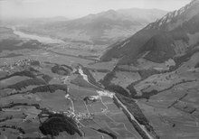
Enney is 720 m above sea level. M. , six kilometers south-southeast of the district capital Bulle (as the crow flies). The clustered village extends on both sides of the Ruisseau du Bry village stream in a hollow on the western edge of the Saan Valley in Haute-Gruyère, at the northeast foot of the La Vudalla mountain, which is part of the Moléson massif . The former municipality area was around 8.5 km². The eastern border formed the Saane (French: Sarine). From here the communal soil extended over the valleys of Ruisseau du Bry and Ruisseau d'Afflon to the west to the heights of Vanil Blanc ( 1573 m above sea level ) and La Vudalla ( 1670 m above sea level ) and into the valley the Albeuve .
population
With 480 inhabitants (2002), Enney was one of the small communities in the canton of Friborg before the merger. The hamlets of La Chenau ( 807 m above sea level ) and Afflon ( 750 m above sea level ) also belonged to the village .
economy
For a long time Enney was a predominantly agricultural village. In the 19th century the Saane was straightened and valuable cultivated land was gained. The animal husbandry and the dairy industry (for cheese production) have today an important place in the economic structure of the population. Today Enney has smaller businesses in the food industry, electronics and a factory that makes concrete elements . In the last few decades the village has also developed into a residential community. Some workers are therefore commuters who work mainly in the Bulle region.
traffic
The village has good transport connections. It is on the main road from Bulle to Château-d'Oex . On July 23, 1903 the railway line from Bulle to Montbovon with stops in Enney and at the junction of the road to Estavannens was put into operation.
history
The area around Enney was settled very early, which was proven by the discovery of a grave from the Bronze Age . The place was first mentioned in a document in 1224 under the names Eis and Eiz . Later the names Ex (1238), Heyz (1254), Eys (1388), Hayes-an-heis (1553) appeared.
Enney has belonged to the county of Gruyères since the Middle Ages . After the last Count of Gruyères went bankrupt in 1554, the village came under the rule of Freiburg in 1555 and was assigned to the Vogtei of Gruyères. After the collapse of the Ancien Régime (1798), Enney first belonged to the prefecture and from 1848 to the district of Gruyères.
On June 5, 2003, the voters of Enney, Estavannens and Villars-sous-Mont voted with a yes majority of over 90% for the merger of the municipalities. With effect from January 1, 2004, the new Bas-Intyamon community was created.
Attractions
The parish church of Saint-Nicolas-de-Flue, a single-nave building with a polygonal choir and front tower, was built between 1619 and 1624. The church has an altar from 1717 and a wooden ceiling from the time it was built.
Web links
- Patrice Borcard: Enney. In: Historical Lexicon of Switzerland .
- Aerial view of the village
Bas-Intyamon | Botterens | Broc | Bull | Châtel-sur-Montsalvens | Corbières | Crésuz | Echarlens | Grandvillard | Gruyères | Hauteville | Haut-Intyamon | Jaun | La Roche | Le Pâquier | Marsens | Morlon | Pont-en-Ogoz | Pont-la-Ville | Riaz | Sâles | Sorens | Val-de-Charmey | Vaulruz | Vuadens
Former municipalities: Albeuve | Avry-devant-Pont | Cerniat | Charmey | Enney | Estavannens | Gumefens | La Tour-de-Trême | Le Bry | Lessoc | Maules | Montbovon | Neirivue | Romance | Rueyres-Treyfayes | Villarbeney | Villars-d'Avry | Villars-sous-Mont | Villarvolard | Vuippens
Canton of Friborg | Districts of the canton of Friborg | Municipalities of the canton of Friborg