
Charmey
| Charmey | ||
|---|---|---|
 |
||
| State : |
|
|
| Canton : |
|
|
| District : | Gruyère | |
| Municipality : | Val-de-Charmey | |
| Postal code : | 1637 | |
| former BFS no. : | 2127 | |
| Coordinates : | 579 019 / 163108 | |
| Height : | 887 m above sea level M. | |
| Area : | 78.44 km² | |
| Residents: | 1993 (December 31, 2013) | |
| Population density : | 25 inhabitants per km² | |
| Website: | www.val-de-charmey.ch | |
 Charmey |
||
| map | ||
|
||


Charmey ( Friborg Patois ) was a municipality in the Gruyère district of the canton of Friborg in Switzerland until December 31, 2013 . The German name Galmis is still used today in the closer German-speaking neighborhood (Jaun). On January 1, 2014, Charmey merged with the former municipality of Cerniat to form the new municipality of Val-de-Charmey .
The municipality of Galmiz in the lake district also bears the French name Charmey . It is called Charmey (Lac) to distinguish it .
geography
Charmey lies at 887 m above sea level. M. , eight kilometers east of the district capital Bulle (linear distance ). The village extends on a terrace above the Lac de Montsalvens reservoir , through which the Jaunbach (French: Jogne) flows, in an open valley basin in the Freiburg Pre-Alps .
With an area of 78.4 km², Charmey is the largest municipality in the canton of Friborg. The area comprises a section of the Freiburg Pre-Alps with strong relief . The central part of the community area is taken up by the valley widening of Charmey, in which the Lac de Montsalvens lies. The Javro , which always forms the north-western border of Charmey, flows into this reservoir from the north . The main inflow of the reservoir is the Jaunbach, which with its valley divides the municipality into a northern and a southern part.
To the north of the Jaunbach, the municipality extends over the rocky ridges of the Dent de Vounetz ( 1813 m above sea level ) and Maischüpfenspitz (French: Vanil d'Arpille , 2085 m above sea level ) into the source area of the Javro. Also the Breccaschlund located in the catchment area of the Schwarzsee , an above-ground run-off valley , partly shaped by cart fields , surrounded by Les Recardets ( 1923 m above sea level ), Schopfenspitz ( 2104 m above sea level ) and Chörblispitz ( 2102 m above sea level ) , as well as adjacent alpine pastures belong to Charmey.
To the south of the Jaunbach and Lac de Montsalvens, the municipality encompasses the mountain range between the valley of the Ruisseau de Motélon in the west and the valley of the Ruisseau du Gros Mont in the east. At the top of the valley of the latter is the Gros Mont Alp . To the west of this are the limestone stocks of Dent de Folliéran ( 2340 m above sea level ) and Dent de Brenleire ( 2353 m above sea level ). The southern border runs over the ridges of Vanil Noir (at 2389 m above sea level, the highest elevation of Charmey), Dent de Savigny ( 2252 m above sea level ), Dent de Ruth ( 2236 m above sea level ) and Wandfluh ( 2133 m above sea level ) m above sea level ). The extensive Alp Petit Mont , located between Hochmatt ( 2152 m above sea level ) and Dent de Ruth, is also part of the municipality. In 1997, 2% of the municipal area was in settlements, 35% in forests and woodlands, 43% in agriculture and around 20% was unproductive land.
To Charmey belong the settlements of Le Pra ( 878 m above sea level ) west of the village, Liderrey ( 935 m above sea level ) and Les Ciernes ( 911 m above sea level ) on the Ruisseau de Liderrey on the western slope of Tissiniva, Les Arses ( 925 m above sea level ) on the western slope of Vounetz, La Tsintre ( 857 m above sea level ) on the Jaunbach as well as numerous individual farms and alpine huts scattered around. Up until December 31, 2013 , the neighboring communities of Charmey were Grandvillard , Bas-Intyamon , Gruyères , Broc , Crésuz , Cerniat , Plaffeien and Jaun in the canton of Friborg, Saanen in the canton of Bern and Rougemont and Château-d'Oex in the canton of Vaud .
population
With 1993 inhabitants (as of December 31, 2013) Charmey was one of the medium-sized communities in the canton of Friborg. 88.0% of the residents are French-speaking, 7.3% German-speaking and 1.7% Portuguese-speaking (as of 2000). The population of Charmey was 852 inhabitants in 1850 and 1247 inhabitants in 1900. After that, it commuted between 1,140 and 1,340 residents for a long time. Only since 1980 (1174 inhabitants) has a significant increase in population been recorded.
economy
Up until the middle of the 20th century, Charmey was a predominantly agricultural village. Until the end of the 19th century, basket weaving (home work) also played an important role. Even today, livestock and dairy farming play an important role in the income structure of the population. Thanks to its large municipal area, Charmey has extensive alpine pastures for grazing livestock. Gruyère cheese and the local variety Charmey are made in the alpine dairies .
tourism
Further jobs are available in local small businesses and in the service sector. In addition to everyday goods and wood processing, the Charmey trade is strongly geared towards tourism (hospitality, hotel and handicrafts). With the construction of cable cars on the Vounetz and ski lifts, the village experienced an economic boom from tourism (both summer and winter tourism) since the 1960s. A project is currently being worked out to use the thermal springs, which were already known in the 18th century, for bathing tourism. In the last few decades the village has also developed into a residential community thanks to its beautiful location. Many workers are therefore commuters who work in the Bulle region.
traffic
In terms of traffic, Charmey is very well developed. It is located on the main road from Bulle over the Jaunpass to Boltigen . Charmey is connected to the public transport network by the Transports publics Fribourgeois bus routes , which run from Bulle to Boltigen and from Freiburg via La Roche to Jaun.
history

Various field and settlement names indicate that Charmey was already inhabited by the Celts . Charmey, for example , means abandoned mountain area , Tissiniva means new huts . After this time, the area was probably uninhabited for a long time until the mid-12th century.
The place was first mentioned in a document in 1211 under the name Chalmeis . In 1294 the name Chermeix appeared ; thereafter the place was called Feiguières until 1760 . Since it was first mentioned, Charmey was under the command of the Lords of Corbières . Also the monastery Valsainte and the Abbey Hauterive owned land on the communal land. In 1249, Charmey became the seat of a branch line of the lords of Corbières when the rule was divided between three brothers. After this line died out in the middle of the 14th century, Charmey was initially administered by a Kastlan.
In 1454 the village was bought by the county of Gruyères . Count Michael von Greyerz's financial difficulties led to the sale of the Corbières dominion to Friborg in 1553. From then on, Charmey was part of the Bailiwick of Corbières. After the collapse of the Ancien Régime (1798), the village belonged to the sub-prefecture of Corbières during the Helvetic period , which was raised to the status of a district in 1803. In 1848, Charmey was incorporated into the Gruyère district with Corbières.
On March 3, 2013, the citizens approved the merger with the municipality of Cerniat .
Attractions
- The parish church of Saint-Laurent, mentioned as early as 1228, has existed in its present form since it was rebuilt between 1735 and 1738; the choir dates from 1937 and contains choir stalls from the 17th century. The local history museum Musée du Pays et Val de Charmey is located in the village.
- In the old town center, characteristic farmhouses from the 18th and 19th centuries have been preserved.
- The hamlet of Les Arses also has a group of such wooden farmhouses from the 18th century.
- There is also a Loreto chapel from 1645 in Les Arses .
- Another chapel worth seeing is Notre-Dame-du-Pont-du-Roc, built in 1693.
- From the former castle Sur la Roche, residence of the sidelines of the Lords of Corbières, only a few remains of the wall are visible.

Les Bains de La Gruyere
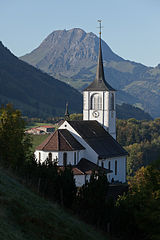
Church with Moléson
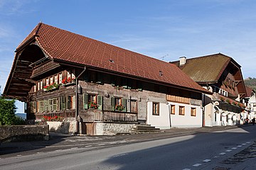
Typical house

Local museum


Personalities
- Jacques Lüthy (* 1959), ski racer
- Jean-François Rime (* 1950), Swiss politician (SVP)
Web links
- Official website of the municipality of Charmey (French)
- Pierre-Philippe Bugnard: Charmey. In: Historical Lexicon of Switzerland .
- Aerial views of the village and its surroundings
Individual evidence
- ↑ Plus de cent personnes pour fêter la fusion de Cerniat et Charmey message on lagruyere.ch of March 3, 2013
Bas-Intyamon | Botterens | Broc | Bull | Châtel-sur-Montsalvens | Corbières | Crésuz | Echarlens | Grandvillard | Gruyères | Hauteville | Haut-Intyamon | Jaun | La Roche | Le Pâquier | Marsens | Morlon | Pont-en-Ogoz | Pont-la-Ville | Riaz | Sâles | Sorens | Val-de-Charmey | Vaulruz | Vuadens
Former municipalities: Albeuve | Avry-devant-Pont | Cerniat | Charmey | Enney | Estavannens | Gumefens | La Tour-de-Trême | Le Bry | Lessoc | Maules | Montbovon | Neirivue | Romance | Rueyres-Treyfayes | Villarbeney | Villars-d'Avry | Villars-sous-Mont | Villarvolard | Vuippens
Canton of Friborg | Districts of the canton of Friborg | Municipalities of the canton of Friborg