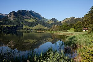
Schwarzsee (lake in the canton of Friborg)
| Schwarzsee | ||
|---|---|---|

|
||
| Schwarzsee | ||
| Geographical location | Canton of Friborg | |
| Tributaries | Euschelsbach, Seeweidbach | |
| Drain | Warm scythe | |
| Places on the shore | Schwarzsee (municipality of Plaffeien ) | |
| Data | ||
| Coordinates | 587 902 / 168240 | |
|
|
||
| Altitude above sea level | 1046 m above sea level M. | |
| surface | 47 ha | |
| length | 1.4 km | |
| width | 500 m | |
| Maximum depth | 10 m | |
The Schwarzsee ( French Lac Noir ; Friborg Patois ) is an approximately 0.5 km² lake in the Swiss canton of Friborg in the Friborg Prealps .
location
The lake is 1046 m above sea level. M. and has a maximum depth of only 10 m. Its banks are mostly flat and lined with meadows and trees, there is only a short section with steep banks in the south. The lake is embedded in the pre-alpine mountain landscape of the Freiburg Alps.
Around the lake are the heights of the Schwyberg ( 1645 m above sea level ) in the west, the rock ridges of Les Reccardets ( 1923 m above sea level ), Spitzflue ( 1954 m above sea level ), Euschelspass ( 1567 m above sea level) . M. ) and the Breccaschlund in the south, as well as the Kaiseregg ( 2185 m above sea level ) in the east.
The only noteworthy tributaries are the Euschelsbach (from the south) and the Seeweidbach (from the southwest). Its outflow to the north is the Warm Sense, a source river of the Sense .
At the northern end of the lake in the area of the outflow of the Warm Sense from the Schwarzsee is the place of the same name Schwarzsee , which belongs to the political municipality of Plaffeien ( Sense district ) and has around 500 permanent residents. The northwest side also belongs to the municipality of Plaffeien. The south-east bank is in the municipality of Jaun and the southern tip in Val-de-Charmey .
use
The village of Schwarzsee consists of farms, chalets and other tourism facilities scattered across the valley . The sulphurous water of the lake has been used for therapeutic bathing for 200 years.
The name Schwarzsee is also used to describe the popular tourist region in the catchment area of the lake. In summer you can go on long hikes in the surrounding mountains, in winter you can go skiing or ice skating on the frozen lake. A chair lift opens up the Riggisalp area, before that there was also a lift up to the Schwyberg. In winter, several ski lifts are in operation on the slopes of the Kaiseregg and Riggisalp. The Schwarzsee belongs to three political communities: the north and west bank belongs to Plaffeien, the east bank to Jaun , and the south bank to Val-de-Charmey . The municipal boundary between Jaun and Plaffeien runs from north to south almost exactly in the middle of the lake.
There is a seven-meter-high observation tower in the area of Plaffeien.
The lake is also an official airfield and is used in winter when the ice is 30 cm thick. The ICAO code is LSWS. Due to this fact, there is a flight restriction for drones determined by the FOCA in this area .

Schwarzsee-Schwinget
Wrestling and alpine festivals have been held at Schwarzsee since 1937 . The Schwarzseeschwinget is one of the important mountain wrestling festivals and takes place annually.
legend

According to legend, the lake became Schwarzsee because the giant Gargantua washed his feet in the lake and the water has been polluted since then.
Web links
- Eveline Seewer: Schwarzsee. In: Historical Lexicon of Switzerland .
- schwarzsee.ch , website about the Schwarzsee
Individual evidence
- ↑ 20 minutes - The Schwarzsee as an airfield 2017
- ↑ Flight restrictions for drones in the LSWS area
- ↑ Schwing- und Älplerfest Schwarzsee - History about the Schwarzsee (PDF), on the Schwarzseeschwinget website, accessed on August 2, 2018
- ↑ Ranking lists , on the Schwarzseeschwinget website, accessed on August 2, 2018


