
Plaffeien
| Plaffeien | |
|---|---|
 |
|
| State : |
|
| Canton : |
|
| District : | Scythe |
| BFS no. : | 2299 |
| Postal code : | 1716 Plaffeien 1716 Oberschrot 1716 Schwarzsee 1719 Zumholz |
| UN / LOCODE : | CH PFN |
| Coordinates : | 588 301 / 176 731 |
| Height : | 856 m above sea level M. |
| Height range : | 746–2238 m above sea level M. |
| Area : | 66.53 km² |
| Residents: | 3594 (December 31, 2018) |
| Population density : | 54 inhabitants per km² |
| Website: | www.plaffeien.ch |
 Plaffeien village |
|
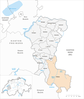
| Location of the municipality | |
  |
|
Plaffeien ( French Planfayon , Senslerdeutsch Plaffeye (n) ; Friborg Patois ) is a municipality in the Sense district of the canton of Friborg in Switzerland . Plaffeien is located in the Senseoberland .
geography

The second largest municipality in terms of area in the canton of Friborg is located in the east of the canton and borders the canton of Bern . The village of Plaffeien is located west of the Sense , the border river between the cantons of Friborg and Bern, on a small plateau surrounded by wooded hills. The village center is divided into two parts by the Dütschbach. The municipal area extends from the village over various hills to the town of Schwarzsee and the Schwarzsee of the same name and the first two-thousand-meter mountains of the Freiburg Pre-Alps . The source area of the Galternbach is located on the slope of the Oberholz (district Oberschrot) .
The lowest point in the community of Plaffeien is at the Sense bed in the fire at 746 m above sea level. M. and the highest point on the Schafberg with 2235 m above sea level. M. . The local mountain Kaiseregg has a height of 2185 m above sea level. M. .
The pass road begins in Plaffeien via Sangernboden over the Gurnigel to Dürrbach (hamlet of the Riggisberg community ).
Neighboring communities of Plaffeien are: Alterswil , Brünisried , Giffers , Jaun , Plasselb , Rechthalten and Val-de-Charmey in the canton of Friborg, as well as Boltigen , Guggisberg and Oberwil in the Simmental in the canton of Bern.
Climate table
| Plaffeien, 1981-2010 | ||||||||||||||||||||||||||||||||||||||||||||||||
|---|---|---|---|---|---|---|---|---|---|---|---|---|---|---|---|---|---|---|---|---|---|---|---|---|---|---|---|---|---|---|---|---|---|---|---|---|---|---|---|---|---|---|---|---|---|---|---|---|
| Climate diagram | ||||||||||||||||||||||||||||||||||||||||||||||||
| ||||||||||||||||||||||||||||||||||||||||||||||||
|
Average monthly temperatures and rainfall for Plaffeien, 1981–2010
Source:
|
||||||||||||||||||||||||||||||||||||||||||||||||||||||||||||||||||||||||||||||||||||||||||||||||||||||||||||||||||||||||||||||||||||||||||||||||||||||||||||||||||||||||||||||||||||
history
The name comes from the Latin planum faegum, which means something like flat beech forest. The first documentary mention comes from the year 1148. From 1486 until the French invasion of Switzerland in 1798, Plaffeien was a bailiwick of Freiburg . In 1848, with the new cantonal constitution, Plaffeien was incorporated into the then newly created Sense District. On May 31, 1906, almost the entire village was destroyed by a fire, the so-called village fire. 51 houses, including the church and the school house, were destroyed by flames. 62 families or 274 people were left homeless. Kasterlee ( Belgium ) has been a partner municipality of Plaffeien since 1979 . Plaffeien has been a member of the Gantrisch Nature Park since 2012 .
In the referendum on September 27, 2015, the voters of the municipalities of Zumholz , Oberschrot and Plaffeien voted for a merger of the three municipalities. This came into force on January 1, 2017.
population
With 3594 inhabitants (as of December 31, 2018), Plaffeien is one of the medium-sized communities in the canton of Friborg. At the end of 2015, before the merger with the communities of Oberschrot and Zumholz , the population was 1982. The dialect spoken in the Sense district is known as " Senslerdeutsch " and belongs to the Höchst Alemannic .
Personalities
- Paul Zbinden (* 1938), Swiss politician (CVP).
- Hans-Peter Pellet (* 1970) Former wrestler
Attractions
The Catholic parish church, rebuilt after the village fire, was consecrated in 1910. It is the largest neo-Romanesque church in the canton of Friborg. The rich paintings were created by Oswald Pilloud (1873-1946) and Otto Haberer-Sinner (1866-1941) in the style of the Beuron art school .
See also
photos

church

village street

school
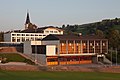
School complex
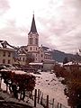
Church of Plaffeien

Aerial photo from 2000 m by Walter Mittelholzer (1925)


_97.jpg)
Web links
- Official website of the municipality of Plaffeien
- Peter F. Kopp: Plaffeien (community). In: Historical Lexicon of Switzerland .
- Video presentation Plaffeien
Individual evidence
- ↑ Permanent and non-permanent resident population by year, canton, district, municipality, population type and gender (permanent resident population). In: bfs. admin.ch . Federal Statistical Office (FSO), August 31, 2019, accessed on December 22, 2019 .
- ↑ Climate table. In: meteoschweiz.admin.ch. meteoschweiz, accessed on June 1, 2018 .
- ↑ Freiburg People's Calendar, 2006 edition, Plaffeien burns! By Moritz Boschung, historian, Düdingen, pages 54–60
- ↑ Official website of the municipality of Plaffeien: Partner municipality Kasterlee. Retrieved June 11, 2020 .
- ↑ Gantrisch Nature Park
- ^ Daniela Schneuwly-Poffet: The Parish Church of Plaffeien. (Swiss Art Guide, Volume 561). Ed. Society for Swiss Art History GSK. Bern 1994, ISBN 3-85782-561-8 .
Alterswil | Bösingen | Brünisried | Düdingen | Giffers | Heitenried | Plaffeien | Plasselb | Keep right | Schmitten | St. Antoni | St. New Years Eve | St. Ursen | Tafers | Tentlingen | Ueberstorf | Wünnewil-Flamatt
Former municipality: Neuhaus | Upper shot | Zumholz
Canton of Friborg | Districts of the canton of Friborg | Municipalities of the canton of Friborg