Upper shot
| Upper shot | ||
|---|---|---|
| State : |
|
|
| Canton : |
|
|
| District : | Scythe | |
| Municipality : | Plaffeien | |
| Postal code : | 1716 | |
| former BFS no. : | 2298 | |
| Coordinates : | 588 004 / 176 824 | |
| Height : | 850 m above sea level M. | |
| Area : | 5.27 km² | |
| Residents: | 1185 (December 31, 2015) | |
| Population density : | 225 inhabitants per km² | |
| Website: | www.plaffeien.ch | |
|
Upper shot FR |
||
| map | ||
|
|
||
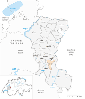
Oberschrot is a village in the municipality of Plaffeien. Until December 31, 2016, it formed an independent political municipality in the Sense district of the canton of Friborg in Switzerland . In a referendum on September 27, 2015, the voters of the communities Zumholz , Oberschrot and Plaffeien voted for a merger of the three communities. This came into force on January 1, 2017.
geography
Oberschrot is at 850 m above sea level. M. , twelve kilometers southeast of the canton capital Friborg (beeline). The village extends on the left northern side of the Dütschbach , directly opposite Plaffeien , west of the upper Sense , in the hill country on the northern edge of the Freiburg Pre-Alps .
The area of the 5.3 km² municipal area comprises a section of the pre-alpine hilly landscape. The central part of the community is occupied by a valley furrow, which connects the valley of the Ärgera in the west with that of the Sense in the east. This valley basin is drained from the Dütschbach towards the east to the Sense. In the north, the area extends to the height with the name Uf der Egg ( 1042 m above sea level ), which belongs to the Oberholz , and into the headwaters of the Galternbach . To the south, the municipality floor extends in a narrow strip up the densely wooded slope ( Oberschrotwald ) and reaches at 1320 m above sea level. M. on the north slope of the Schwyberg its highest point. In 1997, 7% of the municipal area was settled, 34% forest and woodland, 58% agriculture and a little less than 1% was unproductive land.
Oberschrot includes the hamlets of Ried ( 876 m above sea level ), Sahli ( 880 m above sea level ; holiday homes) and Gansmatte ( 892 m above sea level ) in the valley basin at the southern foot of the Uf der Egg, Plötscha ( 860 m above sea level ) above sea level ) on the Dütschbach and various individual farms. Neighboring communities of Oberschrot are Brünisried , Zumholz , Plaffeien , Plasselb , Giffers and Rechthalten .
population
With 1185 inhabitants (as of December 31, 2015) Oberschrot was one of the medium-sized communities in the canton of Friborg. 96.0% of the residents speak German, 2.3% French and 0.7% speak English (as of 2000). The population of Oberschrot was 612 in 1900. After a peak in 1950 (761 inhabitants), the population decreased again slightly until 1980 (708 inhabitants). Since then a significant increase in population has been recorded. Oberschrot has grown together seamlessly with the neighboring village of Plaffeien.
economy
Up until the second half of the 20th century, Oberschrot was a predominantly agricultural village. Even today, the dairy industry and animal husbandry and forestry an important role in the employment structure of the population. Further jobs are available in local small businesses and in the service sector. In Oberschrot there are companies in the building trade, the electrical industry, timber construction and a cheese dairy. Oberschrot works closely with Plaffeien on an economic, cultural and social level. In the last few decades the village has also developed into a residential community. Many workers are therefore commuters who mainly work in the Friborg and Bern regions.
traffic
The community is very well developed in terms of transport. It is located on the main road from Freiburg to Plaffeien . Oberschrot is connected to the public transport network by the bus lines of Transports publics Fribourgeois , which serve the routes from Freiburg via Tafers and Plaffeien to Schwarzsee , from Freiburg via Plasselb and Plaffeien to Sangernboden and from Freiburg via Rechthalten to Plaffeien.
history
With the naming of Ried in 1148, a village on today's parish soil appeared for the first time in the documents. The area later belonged to the Rüeggisberg Priory and the Lords of Englisberg. In 1486 the area came under the rule of Freiburg through purchase and was assigned to the Old Landscape (Burgpanner). As a result, it formed one of the four shot of the parish of Rechthalten .
After the collapse of the Ancien Régime (1798) Oberschrot belonged to the district of Freiburg during the Helvetic and the following period and from 1831 to the German district of Freiburg, before it was incorporated into the then newly created Sense district in 1848 with the new cantonal constitution. With the revision of the Freiburg state constitution in 1831 Oberschrot was raised to an independent political community, but initially still belonged to the parish of Rechthalten. Since geographically the connection with the parish of Plaffeien , whose church is located directly on the border to Oberschrot, was finally taken into account in 1896 the request of the residents. On May 31, 1906, the hamlet of Ried was devastated by a fire.
On January 1, 2017, Oberschrot merged with the municipality of Zumholz to form the new municipality of Plaffeien .
Attractions
Web links
- Website of the former municipality of Oberschrot
- Peter F. Kopp: Oberschrot. In: Historical Lexicon of Switzerland .


