
Ueberstorf
| Ueberstorf | |
|---|---|
 |
|
| State : |
|
| Canton : |
|
| District : | Scythe |
| BFS no. : | 2308 |
| Postal code : | 3182 |
| Coordinates : | 590510 / 190500 |
| Height : | 658 m above sea level M. |
| Height range : | 538–819 m above sea level M. |
| Area : | 16.11 km² |
| Residents: | 2375 (December 31, 2018) |
| Population density : | 147 inhabitants per km² |
| Mayor : | Hans Jörg Liechti ( CSP ) |
| Website: | www.ueberstorf.ch |
_062.JPG) Ueberstorf |
|
| Location of the municipality | |
  |
|
Ueberstorf is a municipality in the Sense district of the canton of Friborg in Switzerland .
geography
Ueberstorf lies at 658 m above sea level. M. , 13 km east-northeast of the canton capital Friborg (linear distance). The village extends on a plateau of the Molasse plateau, which is inclined slightly to the northwest, between the river valleys of Sense in the east and Tafersbach (Taverna) in the west, on the edge of the formerly boggy lowland of the Moos , in the hill country of the eastern Freiburg Central Plateau .
The area of the 16.3 km² municipal area comprises a section of the Molasse hill country west of the Sense, in the far northeast of the canton. The area is bounded in the east and north by the Sense Valley, although the border in the north does not extend all the way down into the valley. Especially in the eastern and south-eastern parts, this river is cut deeply into the molasse layers and is accompanied by steep slopes, some of which are criss-crossed by sandstone rocks.
Ueberstorf reaches its highest point on the so-called Höchi with 818 m above sea level. M. It falls relatively steeply towards the south-east to the scythe, while it has only slightly inclined slopes in the north-west and gradually merges into the undulating hill country of Ueberstorf, which on average is about 650 m above sea level. M. lies. This highland is drained to the north with the Würibach through the Wolfsgraben to the Tafersbach. In the south-west of the village, the communal soil comprises part of the 500 m wide and 2 km long basin of the moss, which was originally a moorland, but is now drained. This hollow is drained through the Ledäu valley between the heights of Blattera ( 714 m above sea level ) and Mischlera ( 720 m above sea level ) to the west, also to the Tafersbach. In 1997, 7% of the municipal area was in settlements, 18% in forests and woodlands, 74% in agriculture and a little more than 1% was unproductive land.
In addition to the actual village, Ueberstorf includes numerous hamlets, farm settlements and individual farms. The most important of these are:
- Obermettlen, 740 m above sea level M. , in a promising location on the northern slope of the Höchi
- Niedermettlen, 657 m above sea level M. , in the valley basin of the Würibach
- Guldifeld, 670 m above sea level M. , a new residential area on the southern slope of the Kriegacher, north of the Würibach Mulde
- Bergli, 665 m above sea level M. , on a knoll north of the Würibach basin
- Third Hüseren, 618 m above sea level M. , on the plateau between the valleys of Würibach and Tafersbach
- Grossried, 628 m above sea level M. , on the high plateau south of Flamatt
- Geretsried, 660 m above sea level M. , on the high plateau north of the Kriegachers
- Riederen, 631 m above sea level M. , on a slope inclined to the east above the Sense Valley
- Blattishus, 665 m above sea level M. , in the valley of the Mülibach
- Hermisbühl, 678 m above sea level M. , in the valley of the Mülibach
- Umbertsried, 730 m above sea level M. , on the northwest slope of the Höchi above Ueberstorf
- Hostettlen, 740 m above sea level M. , on the southern slope of the Höchi, above the Sense Valley
Neighboring communities of Ueberstorf are Heitenried , St. Antoni and Wünnewil-Flamatt in the canton of Friborg and Neuenegg , Köniz and Schwarzenburg in the canton of Bern .
population
With 2375 inhabitants (as of December 31, 2018) Ueberstorf is one of the medium-sized communities in the canton of Friborg. 97.1% of the residents speak German, 0.9% French and 0.2% speak Italian (as of 2000). The population of Ueberstorf amounted to 1515 in 1900. In the course of the 20th century the population fluctuated in the range between 1470 and 1720 people. However, since 1970 (1552 inhabitants) there has been a significant increase in population, especially during the 1990s.
economy
Ueberstorf was a predominantly agricultural village until the second half of the 20th century . Even today, dairy farming , cattle breeding , arable farming and fruit growing have an important place in the income structure of the population. Numerous other jobs are available in local small businesses and in the service sector. In Ueberstorf there are companies in the timber construction, construction and transport industry, electrical engineering, horticulture, mechanical workshops and cheese dairies. In the last few decades the village has also developed into a residential community thanks to its attractive location. Many workers are therefore commuters who mainly work in the Bern and Freiburg regions.
traffic
The community is very well developed in terms of transport. It is located on the main road from Flamatt to Schwarzenburg . The closest connection to the A12 motorway (Bern-Vevey) is around 4 km from the town center. Ueberstorf is connected to the public transport network through the Postbus course, which serves the route from Flamatt to Albligen.
history
The first documentary mention of a place in the municipality of Ueberstorf took place in 1143 with the naming of the Lords of Mettlen, who founded a small lordship that was subordinate to the Counts of Kyburg , von Habsburg and von Thierstein . The center of the Mettlen rule was a castle near Obermettlen, which no longer exists today. Ueberstorf is first mentioned as Ibristorf in 1226 , which means something like Iburin's village (Alemannic personal name). The place name later developed via Jeberinsdorf and bereberstorf to today's Ueberstorf.
In 1442 at the latest, the area came under the rule of Freiburg through purchase from the Counts of Thierstein and was assigned to the Old Landscape (Aupanner). In the course of the 15th century, Ueberstorf developed into the center of the area after the family of the Lords of Mettlen had died out. Until 1538 the village of Albligen belonged to Ueberstorf. After the residents of Albligen had converted to the new faith, the village was spun off and added to the common lordship of Grasburg (now part of the canton of Bern).
After the collapse of the Ancien Régime (1798), Ueberstorf belonged to the Freiburg district during the Helvetic and the following period and from 1831 to the German district of Freiburg, before it was incorporated into the newly created Sense district in 1848 with the new cantonal constitution.
Other important historical events
- 1476 - A Ueberstorfer troop rushes to the aid of the confederates in the battle of Murten
- 1538 - Albligen definitively separates from Ueberstorf
- 1798 - Ueberstorfer put up considerable resistance when Freiburg was occupied by the French. Among other things, the freedom tree was torn down and a high-ranking Helvetian official was injured
- 1799 - As revenge, the Helvetii and French plunder Ueberstorf, which leads to the village fire
- 2006 - A merger of the neighboring Albligen with Ueberstorf is up for discussion, although the different cantons stand in the way.
- September 2008 - The Albligen municipal assembly voted 101 to 94 against a merger with Ueberstorf and in favor of a merger with voters .
Attractions
The parish church of Johann Baptist was built in 1898 on the site of a previous building; Parts of the earlier church, such as the tower, were taken over. The sights of Ueberstorf also include three castles that were built by rich Freiburg families. In the middle of the village is Englisberg Castle, which was built in 1505 and was owned by the Ingenbohl sisters from 1881 to 1971. Today the restored building serves as a cultural and meeting place as well as a conference venue. The Techtermannhaus was built in the 18th century as a French-style country estate and housed the village school from 1912 to 1971. Reyff Castle, where the Freiburg architect and sculptor Hans-Franz Reyff lived, dates from the end of the 16th century .
In the town center and in the hamlets, characteristic farmhouses from the 17th to 19th centuries have been preserved. There are chapels in some hamlets.
photos

Englisberg Castle

Church of Ueberstorf
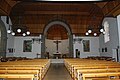
Interior of the church

Half-timbered house in the village


_016.JPG)
coat of arms
In 1476 a troop from Ueberstorfer and the confederates allied with them moved to Murten to fight the Burgundians. As a tribute to their loyalty and support, the city of Murten gave the Ueberstorfern the right to use the red Murten lion (without a crown) as a heraldic animal. At the beginning of the 20th century, the old coat of arms was merged with that of Messrs. Von Mettlen (blue and white striped), resulting in today's municipal coat of arms.
Personalities
- Christine Bulliard-Marbach (* 1959), Swiss politician , national councilor
Web links
- Official website of the municipality of Ueberstorf
- Moritz Boschung: Ueberstorf. In: Historical Lexicon of Switzerland .
Individual evidence
- ↑ Permanent and non-permanent resident population by year, canton, district, municipality, population type and gender (permanent resident population). In: bfs. admin.ch . Federal Statistical Office (FSO), August 31, 2019, accessed on December 22, 2019 .
Alterswil | Bösingen | Brünisried | Düdingen | Giffers | Heitenried | Plaffeien | Plasselb | Keep right | Schmitten | St. Antoni | St. New Years Eve | St. Ursen | Tafers | Tentlingen | Ueberstorf | Wünnewil-Flamatt
Former municipality: Neuhaus | Upper shot | Zumholz
Canton of Friborg | Districts of the canton of Friborg | Municipalities of the canton of Friborg