
Düdingen
| Düdingen | |
|---|---|
 |
|
| State : |
|
| Canton : |
|
| District : | Scythe |
| BFS no. : | 2293 |
| Postal code : | 3186 |
| UN / LOCODE : | CH DIG |
| Coordinates : | 581 078 / 188360 |
| Height : | 596 m above sea level M. |
| Height range : | 486–708 m above sea level M. |
| Area : | 30.76 km² |
| Residents: | 7964 (December 31, 2018) |
| Population density : | 259 inhabitants per km² |
| Mayor : | Kuno Philipona ( CVP ) |
| Website: | www.duedingen.ch |
 Grain silos |
|
| Location of the municipality | |
  |
|
Düdingen (French: Guin , Freiburger Patois ) is a municipality in the Sense district of the canton of Friborg in Switzerland . The community is located east of the Schiffenensee in the middle of the German-Freiburg Central Plateau. With more than 7,000 inhabitants, it is one of the large communities in the agglomeration of the city of Freiburg .
geography

As the westernmost municipality of the lower Sense district, the municipality slopes towards the west and southwest of the Saane . Here the Saane forms the Schiffenensee and at the same time forms the district boundary. The Düdingerbach (also called Horiabach on the upper reaches) divides the community into two similarly sized areas.
The lowest point is 498 m above sea level below the dam of the Schiffenensee; the highest point can be found at Dählhölzli at 703 m.
In terms of area, Düdingen, with 3,086 hectares, is the sixth largest municipality in the canton and the second largest in the Sense district after Plaffeien .
Düdingen essentially consists of a village with a core and neighboring quarters and a large number (around 20) of small hamlets .
Nine municipalities and two districts border on Düdingen: on the Sense district - Tafers , Schmitten and Bösingen ; to the lake district communities of Kleinbösingen , Gurmels and Courtepin ; to the Saane district communities of La Sonnaz , Granges-Paccot and Freiburg .
population

With 7,964 (as of December 31, 2018) inhabitants, Düdingen is the fifth largest municipality in the canton of Friborg after Friborg , Bulle , Villars-sur-Glâne and Marly .
In 1995, 13.8% of the population were citizens of Düdingen, 51.7 were citizens from other municipalities in the canton, 28.2% were citizens of other cantons and the remaining 6.3% were foreigners.
A population census from 1447 showed 629 inhabitants including the area that today belongs to the community of Schmitten. Some hamlets (Bundtels with 60 and Jetschwil with 55 inhabitants) were more populous than the village of Düdingen with 51 inhabitants.
The population has increased steadily since the beginning of the 19th century, reaching more than 7,000 in 2005 . Only in 1922 is there a kink that can be traced back to the separation of the Schmitten community (see also history).
languages
Düdingen is a German-speaking community. Because of its proximity to the city of Freiburg, there has always been a small minority of French-speaking residents.
| native language | Share (1990) | Share (2000) |
|---|---|---|
| German | 91.9% | 89.7% |
| French | 4.3% | 4.5% |
| Other | 3.8% | 5.8% |
Religions - denominations

In Düdingen there are the Roman Catholic and the Evangelical Reformed Churches recognized under public law. There is also the Free Evangelical Congregation as a confessional community organized under private law. The relationship between the denominations has changed little since 1860.
| religion | Share (1860) | Share (1900) | Share (1950) | Share (2000) |
|---|---|---|---|---|
| Roman Catholic | 88.1% | 83.8% | 86.5% | 72.4% |
| Evangelical Reformed | 11.9% | 16.2% | 13.1% | 16.1% |
| Others including non-denominational | 0% | 0% | 0.4% | 11.5% |
politics
legislative branch
From 1873 for a few years and from 1982 to 1991 there was a municipal parliament in Düdingen with 50 members (General Council). It was abolished again in a referendum held in 1990. Instead, the highest authority was the community assembly , which takes place at least twice a year. The community assembly decided on the estimate and the invoice as well as on all other important business of the community. On May 1, 2016, a municipal parliament (General Council) with 50 members and a five-year term of office was again introduced in the municipality.
executive
The executing authority is the municipal council . It consists of 9 members and is elected for 5 years at the ballot box. The council elects the mayor (also called Ammann or Syndic ) from its own ranks.
Allocation of seats in the municipal council by party (legislature 2011 to 2016)
| Political party | Number of representatives | |
|---|---|---|
| CVP | Christian Democratic People's Party | 4th |
| SP | Social Democratic Party | 1 |
| FWD | Free voters Düdingen | 1 |
| SVP | Swiss People's Party | 2 |
| FDP | Liberal Democratic Party | 1 |
Judiciary
Düdingen belongs to the 3rd district court of justice in the Sense district with its seat in Schmitten. Criminal court cases and major civil court cases are dealt with by the District Court in Tafers.
economy
Economically, as everywhere in Switzerland, there has been a shift in employment of the population from the primary sector (agriculture) in favor of sectors 2 (industry and commerce) and 3 (services). In terms of proportion, the agricultural sector declined from 46.5% in 1930 to 7.9% in 1990, while the industrial sector increased from 29.7% to 33.7% and the service sector from 23.8% to 57.7%.
In 2000, 1,353 jobs were available for a total of 3,675 employees in Düdingen. The remaining 2,427 (66%) employees earn their living outside the community.
Agriculture
With 2000 hectares, which makes up 70% of the total area, Düdingen has the largest agricultural area in the canton. The number of farms has steadily decreased since the beginning of the last century: from 245 farms in 1929, there were 97 in 2001.
The dairy industry is of great importance. Three cheese dairies (Bundtels, Mariahilf and Düdingen) process one of the largest quantities of milk in Switzerland into cheese.
Until the middle of the 19th century, the cultivation of grain was predominant. Due to ships and railways, the grain prices fell very sharply, so that a quick switch to cattle breeding took place. Even today, cattle breeding is an important source of income for the farmers, as the figures from 1993 express it:
- Bee colonies: 403
- Chickens: 71,841
- Rabbit: 601
- Horses: 62
- Ponies / donkeys: 12
- Cattle: 3,126
- Of which cows: 1,233
- Sheep: 610
- Pigs: 3,310
- Goats: 18
Further agricultural branches in Düdingen are fruit growing , fruit processing, potato cultivation, seed cultivation , forestry , several tree nurseries and market gardens.
Industry and commerce
A wide variety of companies have settled in Düdingen in several batches. From the end of the 19th century to 1905, mainly agricultural and soil products were used (establishment of the dairy , cider and brickworks ). An expansion of the products was achieved during the twenties and thirties through a match factory (closed again in 1947) and through the cement goods factory . From 1952, with the establishment of a diamond grinding shop, all other operations followed in a wide variety of areas (machine works, pharmaceuticals, light metal foundries, plastics, color binders , etc.). The provision of industrial zones, an accommodating tax policy and existing workforce favored the establishment of the companies.
The trade has been organized at the district level since 1905. There is a trade association in Düdingen. The most important businesses produce food and process various materials. Construction companies and auto repair shops are also well represented.
Service sector
The third sector has been expanding continuously for around 50 years and has a very diversified range. Many service businesses are run on the private side: garages, driving schools, radio, television and computer businesses, architecture, trust and engineering offices, insurance agencies and beverage dealers. Other services are also provided by associations: kindergarten, adult education, gymnastics and sport. Cooperative and joint stock companies are also represented in this sector.
tourism
Düdingen is one of the more than 60 tourism communities recognized by the canton. The infrastructure includes several hotels with a total of around 70 beds, various restaurants and country inns, a dancing and a campsite right by the dam with mini golf, tennis court, bocce court and more than 60 boat places on the lake shore.
Hiking and cycling trails facilitate access to the natural beauties and cultural objects (see sights).
traffic
In terms of traffic, Düdingen is very well developed. Three main modes of transport cross the municipality from southwest to northeast: the Freiburg- Bern railway line , the A12 motorway and the Freiburg-Bern cantonal road. From the south, two cantonal roads from Friborg and Tafers meet to divide north again towards Murten and Laupen . This makes Düdingen a regional hub.
Düdingen is easily accessible by public transport. Hourly rail connections (Bern S-Bahn line S1, every half hour from December 2008) and numerous Postbus courses lead to and from Düdingen.
Sometimes the motorway connection leads to chronic traffic jams at the motorway exit and through the village, especially when starting work in the morning and at the end of work in the evening. 15,000 vehicles drive through the main road every day (1994). Studies for a bypass road exist.
history
Names
The German name Düdingen and the French name Guin both go back to the basic form Tudingun . Tudingun comes from the personal name Dodo or Dudo and the Alemannic -ingun suffix. Presumed meaning: among the people of the dudo . From the Alemannic -ingun (ingen) this has Romanesque -ens developed whereby Düns emerged. Duens is first mentioned in 1182 in a Latin document from the Hauterive monastery .
In the patois , Duens Dyäng was pronounced and later translated into Guin in French . Guin is first attested in 1755.
In dialect , Düdingen is pronounced Tüdinge . Tidinge can also be heard less frequently .
Over the centuries the name has been documented in various ways in documents or maps: 1182 Duens , 1258 Tiudingen , 1287 Tudingen , 1414 Duyng , 1578 Tüdingen , 1668 Didingen .
From the Stone Age to Roman rule
The oldest traces of human life in the community come from the Middle Stone Age (40,000 to 8,000 BC). Parts of hunting tools from this period were found on the banks of the Saane. The first farmers settled in the younger Stone Age (5,000 to 1,800 BC). A settlement on the Schiffenensee with a stone ax-blade workshop has been proven. A spindle whorl (corridor impact) and ceramic shards (corridor Zelg) testify to the Bronze Age (1,800 to 750 BC). Various grave goods such as bracelets, chokers and fibulas have come down to us from the Hallstatt period . There are also several tumuli ( tumulus are more or less round burial mounds) known from this period (Bundtels, Chiemiwald, Birchholz, Klempa). The settlement increased in the Latène period (450 BC to 0). From this time a woman's grave was discovered during the construction of the railway line between Garmiswil and Balliswil. It was the time of the Helvetii . From the time of the defeat against the Romans at Bibracte in 58 BC. Roman traces are also present. Ruins were discovered in three places (Chiemiwald, Ottisberg and Balliswil). Several other finds (silver coin and mill wheel) were also found.
Origin of the community
From the early Middle Ages (400 to 800) there are no known finds with certainty. There are also no written certificates from this epoch. The migration of peoples, especially the advance of the Alemanni , was stopped in the neighborhood, which brought the municipality into the language border zone. The area was Christianized. The parish was first mentioned in 1228 . From the founding of the city of Freiburg (1157), its influence became more and more noticeable. The Lords of Düdingen (the Duens and later the Velga) gained respect in the city and provided several mayors .
On February 12, 1378 Jakob von Düdingen sold his share in the Simmental to the city of Freiburg for 3000 guilders . On February 24th, Wilhelm von Düdingen also committed to keep his castles ( Blankenburg , Mannenberg and Laubegg ) open for the city of Freiburg . The Simmental as well as Nidau and the Inselgau (Seeland) with almost the entire area lost Freiburg to Bern after the Sempach War, in a guerrilla war with Bern and after a decision by an arbitration tribunal.
1476 Murtenschlacht, with a "Reisgesellschaft (Compagnie)" of 63 equipped men,
From the middle of the 15th century, the city of Freiburg dominated the entire old landscape . Up to and including the Sonderbund War in 1847, Düdingen was always on the side of the city. From 1817 an Ammann is mentioned in Düdingen and a separate protocol is kept. In 1831 the political community, which has been part of the newly created Sense District since 1848, was finally formed.

Separation of Schmittens
During the time of the Old Landscape , the parishes of Bösingen, Tafers, Wünnewil, Ueberstorf, Heitenried and Düdingen formed one of the four Panner : the Aupanner. The parish of Düdingen in turn was divided into four shot: Düdingen, St. Wolfgang, Lanthen and Wiler. In 1831 and 1853 the government tried to achieve independence for the two shot Wiler and Lanthen with a center in Schmitten, but the attempts failed because of the resistance of the Düdingen population and authorities. However, the efforts continued. A parish rectorate was founded in 1885 and Schmitten's own parish in 1894. By a decree of the Great Council, Schmitten was declared an independent municipality in 1922 and separated from Düdingen.
Industrial community
Düdingen was hit hard by the economic crisis of 1929 (popularly just called "the crisis"). It weighed on industry, trade and commerce as well as on agriculture. Towards the end of the Second World War, a certain upswing was noticeable. The new secondary school was built (in 1943 for the boys and in 1944 for the girls). In 1946 the first local planning was passed. A new phase of development began in the 1950s. In a short time the infrastructure was greatly expanded, the population increased and the appearance of the town changed. The development was accelerated by the construction of the A12 motorway in 1981. Today, Düdingen is both an important industrial location and an important economic center in the region.
coat of arms
The ox head and the flowers were chosen as a coat of arms due to a legend. In this legend, an ox saved the Düdinger church relics. They tied the relics on his horns and hid him from the enemy troops. The ox was then found in a pasture (hence the 3 flowers). However, this is only one of several theories of how the coat of arms came about.
Art and culture
schools
All training opportunities from kindergarten to orientation school exist in the community. Düdingen has more than 1000 students. The following special services are also available: School psychology service, psychomotor service, speech therapy service, career counseling, German lessons for foreign-language children, school dental clinic and a music school. The schools are located in five locations (two for kindergarten, two for primary school and one for orientation school).
Attractions

There are a number of sights to admire in Düdingen. Below is a list of the most notable ones:
architecture
- bridges
- The Grandfey Viaduct is the largest structure on the Lausanne-Bern railway line. The bridge was built from 1858 to 1862 as an iron structure. The bridge was set in concrete from 1925 to 1927. The bridge is 334 m long and has a maximum height of 79 m. The bridge can also be crossed on foot or by bike. This made it a popular destination.
- The Magdalena Bridge is the motorway bridge that crosses the Schiffenensee. It is 315 m long and the maximum height is 49 m.
- The Düdingerbach forms a wooded cut below the village: the Toggeliloch. Two Toggeli hole bridges were built: one for the railroad and one for the motorway. The railway bridge was built in 1859 as a steel structure and in 1926/27, like the Grandfey Viaduct, concreted in. It is 117 m long, 9.50 m wide and the maximum height is 32 m. The motorway bridge was built in 1968. It is 120 m long and has a maximum height of 21 m.
- Castles: in several hamlets there are former mansions or other houses with a stately appearance. These are popularly called castles.
- Farms: many farmhouses from earlier times enrich the landscape
- Cemeteries: The new cemetery was inaugurated in 1991. The park-like facility is supplemented with a covered area and invites you to reflect.

nature
- Düdinger Möser: it is a flat moor of about 100 hectares southwest of the village. The moor is under nature protection and has been included in the federal inventory of the fens.
- Botanical path: in the Chiemi Forest and in the Düdinger Mösern there is a botanical path. The tour lasts around 1½ hours and shows around 60 indigenous moor, meadow and forest plants, each with labeled boards.
Religious constructions
- Chapels: There are ten free-standing chapels in Düdingen. Most are in the hamlets (Balliswil, Bruch, Bundtels). There are also some house chapels. The pilgrimage chapel of the same name from 1727, which was once known, is located in the hamlet of Mariahilf.
- Waypoints: There are about twenty in the entire municipality. There is also a Lourdes grotto in the Bruger Forest.
- Magdalena Hermitage : It is located near the hamlet of Räsch. The system is 120 meters long and 20 meters wide. A chapel, several living rooms and corridors are carved into the rock. The hermitage has been inhabited by secular and ecclesiastical hermits for centuries. In 1609 a first Klausner is mentioned. The last one left the place in the interwar period.
- Church: The current building is the third to be constructed over the centuries. The current building dates from the years 1834 to 1837. The church is spaciously built in Biedermeier classicism.
photos

Main road

Parish church
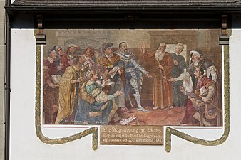
Mural "Tagsatzung" (parish church)

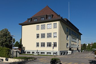
Local government
reformed Church
Schoolhouse Gänseberg
Wolfacker school house

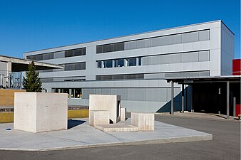
OS schoolhouse


regional customs
Some old customs and traditions have been preserved in Düdingen. Most of the customs are of church origin.
- Corpus Christi procession: During this procession colorful costumes and uniforms can be admired.
- St. Nicholas in December: On the one hand, the Santiklous goes by families on request, on the other hand, you can visit it in the forest. Samichlous Düdingen
- Blessings: Neck blessing on the Sunday after the feast of St. Blaise (February 3), Blessing of Agatha bread on Agatha -Fest (February 5)
- Maisingen : On May 1st, the children go from house to house in Maisingen .
- Martinsmarkt: This market is held every 2nd Saturday in November. It is also the Düdinger Kilbi , where the Kilbi menu is served (several courses with local specialties).
Hamlets, places, corridors
Numerous hamlets are scattered across the municipality:
Angstorf
Angstorf is on the old road from Düdingen to Tafers. The place, first mentioned in 1379 with the name Anstorf , is an early Alemannic settlement. A manor house (castle), a house with a fully hipped roof from 1741 and a well-preserved granary from 1652 characterize the small hamlet.
Bad Bonn
The spa town of Bad Bonn , known for centuries, was located on the right bank of the Saane, opposite the Grand and Petit-Vivy palaces on the left bank . Bonn experienced a heyday from the 17th to the 19th century. The bath and hamlet had an area of 512 m². Bad Bonn included the bath, a central wing with a hall, the tavern and a small chapel, which was built in 1621 when Bonn was owned by the state of Freiburg. In 1647 the bath was destroyed by fire with the exception of the chapel and rebuilt in 1650/1651.
In 1960, the Gotthelf adaptations Anne Bäbi Jowäger - Part I: How Jakobli comes to a woman and Anne Bäbi Jowäger - Part II: Jakobli and Meyeli were filmed in Bad Bonn . A little later the bathroom was torn down. In 1963, the Schiffenensee flooded the stately houses, the chapel and the suspension bridge. The altar of the chapel was later rebuilt in the church of Düdingen.
The formerly almost glamorous spa hotel Bad Bonn has been replaced by a country inn of the same name. Today the more than 500-year old Kilbi tradition is continued there in the Bad-Bonn-Kilbi , one of the most important indie festivals in Europe.
Balbertswil
The closed hamlet is first mentioned in 1323 as Balwartswile . A manor from the end of the 17th century and a granary from the 16th century are worth mentioning.
Balliswil
Balliswil is first mentioned in 1388 as Baliswile . A manor house, a tenant farm, a Marienkapelle and other buildings are the components of the hamlet. Up until the completion of the Grandfey Bridge, Balliswil was the terminus of the railway towards Freiburg between 1860 and 1862.
Break (front, back)
Behind Bruch is a manorial hamlet with a chapel. The house was probably extended to a cube shape with a hipped roof at the beginning of the 19th century. The chapel dedicated to St. Jost was first mentioned in 1519. A small country house in the style of the manor house from the 18th century belongs to the hamlet of Vorder Bruch.
Bundtels
The remarkable townscape characterizes the tightly packed, closed hamlet. He is first mentioned as Pontels in 1172 . Today's neo-Gothic Katharinenkapelle was built in 1862. However, a chapel existed as early as the 12th century. A granary from 1597 is one of the oldest in the community. Until the middle of the 15th century, Bundtels had more inhabitants than Düdingen.
Chastels
Around 300 m southwest of the hamlet of Chastels (first mentioned in 1388) is the location of the former Chastels castle, which was destroyed in 1331 (from the Latin castellum = castle). Below the castle site there was once a hermitage with a little Antonius bed.
Galmis
Galmis, first mentioned in 1388, is one of the few hamlets in the region that have remained intact. It is a so-called two-line hamlet: the farmhouses are lined up, while the associated ancillary buildings are on the other side of the street. The hamlet is classified as a historical monument.
Heitiwil
The hamlet is elongated and includes Heitiwil Castle from the end of the 18th century. The hamlet was first mentioned in 1329 under the name Heytenwile .
Jetschwil
Hamlet that has remained intact and is perfectly embedded in the landscape with a townscape of national importance. The place was first mentioned in 1243 as Uchenwile . Later mentions were Ochinwile and Uetschenwyl . The current castle was built in 1765 by the de Boccard patrician family . Several 18th century farmhouses and granaries are also part of the hamlet. In 2006 the first Minergie-P house ( passive house ) in the canton of Friborg was built in Jetschwil.
Ottisberg
Ottisberg, first mentioned under the name Othersperch in 1306, is a loosely built hamlet with a country house, chapel and several farmhouses. The country house from 1841 served as a retirement home from 1921 to 1964.
St. Wolfgang
The place, formerly named Zur Schöne Buche , is a place of pilgrimage on the Düdingen-Freiburg road with a connection to Jetschwil. The Wolfgang Chapel was once a well-known and much-visited place of pilgrimage. A complete renovation took place in 1983/84.
Übewil
The hamlet on the outskirts of Freiburg was first mentioned in German as Ybenwile in 1299 and in French as Villars-les-Joncs in 1300 . It consists of farmhouses, a chapel and a castle. The castle was built in 1765 as a typical country house with a mansard roof.
Other places worth mentioning
Alberwil, Bäriswil, Birch, Brugera (single farmstead with a sensler Kreuzfirsthaus), Briegli, Boccarda, Chastelsberg, Felliwil, Garmiswil (first mentioned in 1301 as Garmanswile ), Guggerhorn, Heitera, Hinterbürg, Horia, Lamprat, Lengmatt, Luggiwil (first mentioned in 1379 ) mentioned), Lustorf , Mariahilf (place of pilgrimage), Meierisli, Menziswil (first mentioned in 1293 as Menziswile , the Marienkapelle is on the ground of the community Düdingen, but belongs to the parish Tafers), Räsch, Rippa, Rüti, Staad, Steinler, Strittacker, Stockera, Schlattli, Schiffenen (first mentioned in 1263 as Shivuennon , the nearby Schiffenen reservoir owes its name to this place), Schüracker, Waldegg, Warpel, Wilera, Wittenbach, Zelg, Zelgli.
Personalities
- Alfons Aeby (1885–1941) was a seminar teacher and writer. He wrote short stories, novels and plays, books for the classroom, and studies of local history and art history. He also worked as a director. His last novel is called Der Überwinder from 1934. In Düdingen a street was named after his name.
- Alphonse Roggo (1898–1980), Councilor of State, was elected to the Council of States in 1960 as the first Sensler.
- Adolphe Merkle (1924–2012) was an entrepreneur and patron. He was born in Düdingen.
- René Brülhart (* 1972), President of the Vatican Financial Information Authority since 2014
literature
- Sense district 1848 1998, German-Freiburg contributions to local history, Volume 64, 1998
- Düdingen Sketch of a municipality published by the Düdingen municipality in 1982
- Düdingen from a to z published by the municipality of Düdingen in 1995
Web links
- Official website of the community of Düdingen
- Düdingen Tourism
- Statistique Friborg
- Denis Ramseyer and Olivier Aebischer: Düdingen. In: Historical Lexicon of Switzerland .
- Alfons Brügger: St. Wolfgang. In: Historical Lexicon of Switzerland .
Individual evidence
- ↑ Permanent and non-permanent resident population by year, canton, district, municipality, population type and gender (permanent resident population). In: bfs. admin.ch . Federal Statistical Office (FSO), August 31, 2019, accessed on December 22, 2019 .
- ↑ http://www.schiffenensee.ch/-geschichte-des-stausees/bonn/kurort-bad-bonn.html Kurort Bad Bonn
- ↑ http://www.woz.ch/1242/duedingen-bad-bonn/wo-zur-hoelle-gende-denn-bloss-bad-bonn Festival Bad-Bonn-Kilbi
Alterswil | Bösingen | Brünisried | Düdingen | Giffers | Heitenried | Plaffeien | Plasselb | Keep right | Schmitten | St. Antoni | St. New Years Eve | St. Ursen | Tafers | Tentlingen | Ueberstorf | Wünnewil-Flamatt
Former municipality: Neuhaus | Upper shot | Zumholz
Canton of Friborg | Districts of the canton of Friborg | Municipalities of the canton of Friborg