
Gurmels
| Gurmels | |
|---|---|
 |
|
| State : |
|
| Canton : |
|
| District : | lake |
| BFS no. : | 2262 |
| Postal code : | 3212 |
| Coordinates : | 579 676 / 193522 |
| Height : | 542 m above sea level M. |
| Height range : | 475–668 m above sea level M. |
| Area : | 17.34 km² |
| Residents: | 4352 (December 31, 2018) |
| Population density : | 251 inhabitants per km² |
| Website: | www.gurmels.ch |
_292.JPG) Gurmels |
|
| Location of the municipality | |
  |
|
Gurmels ( French : Cormondes; in the neighboring Franco-Provencal dialect ) is a political municipality in the lake district (French: District du Lac) of the Swiss canton of Friborg . The present-day large community of Gurmels, consisting of the actual village of Gurmels as well as Kleingurmels , Monterschu , Guschelmuth , Cordast , Liebistorf and Wallenbuch , was created through various community mergers .
geography
Gurmels lies at 542 m above sea level. M. , 6 km southeast of the district capital Murten (linear distance). The clustered village extends on the southern edge of the broad valley lowlands of the Biberen , in a hollow on both sides of the Cordastbach, at the western foot of the Grossholzes, in the northern Freiburg Central Plateau .
The area of 17.2 square kilometers large municipal area comprises a portion of the glacial Rhonegletscher overmolded Molassehöhen between the Morat in the northwest and the Saanen valley in the southeast. The central part of the municipality is the up to 1 km wide basin near Gurmels, through which the Biberen flows, in the east from Grossholz ( 604 m above sea level ), in the south from the height near Monterschu and in the west from the hilltop Lengi Zelg (up to 600 m above sea level ) is limited. To the southeast, the community area extends over a flat saddle to the Schiffenensee near its dam. In the northwest, the border always runs in the area of the Biberental.
To the southwest of Gurmels, the municipality extends over the valley of the Cordastbach, flanked by the ridge of Lengi Zelg and the Bulliardholz (at 668 m above sea level, the highest point of Gurmels) to the high plateau of Cordast with the headwaters of the Biberen and the heights of the Monterschuwaldes ( 667 m above sea level ) and the Bouleywaldes ( 666 m above sea level ).
To the northeast, the area extends down the valley along the Biberen, which is flanked here in the north by the Galmwald ( 588 m above sea level ), in the south by Kapitelwald and the Röseliwald , which already belongs to the canton of Bern . The village of Wallenbuch on a plateau between the valleys of Biberen and Saane belongs to Gurmels as an exclave. In the far east, the municipality extends over the wooded steep slope down into the broad valley plain of the Saane. In 1997, 8% of the municipal area was settled, 20% forest and woodland, 71% agriculture and a little less than 1% was unproductive land.
Gurmels consists of:
- the village of Gurmels, 542 m above sea level. M. , 1540 inhabitants, with the district Dürrenberg ( 542 m above sea level ) in the valley of the Biberen to the east of Gurmels and the hamlet of Monterschu ( 599 m above sea level ) on the height between the Cordastbach and the Schiffenensee.
- Cordast , 607 m above sea level M. , 780 inhabitants, on a plateau west of the Bulliardholz.
- Guschelmuth , 327 inhabitants, consisting of Grossguschelmuth ( 581 m above sea level ) and Kleinguschelmuth ( 566 m above sea level ), both on the right slope of the Biberen valley.
- Liebistorf , 524 m above sea level M. , 642 inhabitants, in the Biberental southeast of the Galmwald.
- Wallenbuch , 532 m above sea level M. , 132 inhabitants, on a plateau between the Biberental and the Saane Valley.
In addition, several hamlets and numerous individual farms belong to Gurmels. Neighboring communities of Gurmels are Kleinbösingen , Düdingen , Courtepin , Cressier , Murten , Ulmiz and the state forest Galm in the canton of Friborg and Laupen , Kriechenwil and Ferenbalm in the canton of Bern .
population
With 4,352 inhabitants (as of December 31, 2018), Gurmels is one of the medium-sized communities in the canton of Friborg. 92.7% of the residents speak German, 4.1% French, 1.2% speak Italian and 2% speak another language (as of 2006). The population of Gurmels was 1655 inhabitants in 1900 (including all the villages that have since been incorporated). In the course of the 20th century, the population increased slowly but continuously until 1970 (1981 inhabitants). Since then, population growth has increased significantly, particularly during the 1990s.
economy
Until the middle of the 20th century, Gurmels was a predominantly agricultural village. Even today, arable farming , fruit growing , dairy farming and cattle breeding play an important role in the income structure of the population. Numerous other jobs are available in local small businesses and in the service sector. In Gurmels and its neighboring communities, companies in the building trade, IT, metal construction, precision mechanics as well as joineries and locksmiths are represented today. Gurmels is the location of the retirement home Hospiz Sankt Peter. In the last few decades the village has also developed into a residential community. Many employed people are therefore commuters who work mainly in the regions of Freiburg , Murten and Bern .
traffic
The community is very well developed in terms of transport. It is located on the connecting road from Murten to Düdingen . The nearest connections to the A1 (Bern-Lausanne) and A12 (Bern-Vevey) autobahns are each around 7 km from the center of Gurmels. Gurmels is connected to the public transport network through the Postbus courses that run on the routes from Murten to Düdingen and from Kerzers to Düdingen.
history
The municipality of Gurmels was populated very early. Individual traces of the presence of humans in the Neolithic were discovered in the Biberental. The area was also inhabited during the Roman and Burgundian times, which could be proven by a burial ground near Dürrenberg.
The first written mention of Gurmels was in 1186 under the name of Cormulnes . Later the names Cormunt (1228), Cormugnes (1242) and Curmmonnes (1363) appeared. The German versions are from 1240 (Gurmols), 1246 (Gurmurs) and 1250 (Gurmels) . The place name goes back to the Latin word curtis (court) and the Germanic personal name Mundo and therefore means court of Mundo .
Gurmels was owned by the Counts of Thierstein since the Middle Ages . In 1442 the village came under the rule of Freiburg through purchase and from then on belonged to the Old Landscape (Spitalpanner). Gurmels was ravaged by severe fires in 1525 and 1605. After the collapse of the Ancien Régime (1798), Gurmels belonged to the Murten district during the Helvetic Republic, from 1803 to the Freiburg district and from 1831 to the German district of Freiburg, before it was incorporated into the lake district in 1848 with the new cantonal constitution.
Parish mergers
The first community merger took place on January 1, 1978, when the hamlet of Monterschu was merged with the main village then known as Grossgurmels , with the new community being called Gurmels from then on. As part of the community mergers funded by the canton of Friborg since 2000, another merger took place right at the beginning on January 1, 2000, when Kleingurmels was incorporated.
At the community assembly on June 28, 2002, Guschelmuth and the Friborg exclave Wallenbuch decided clearly, and Liebistorf relatively narrowly, in favor of incorporation into Gurmels. The merger became final on January 1, 2003. On January 1, 2005, the former Cordast community joined the new Gurmels community. This was done retrospectively, as proceedings before the cantonal administrative court were still pending after the planned merger date.
Attractions
The parish church of Sankt German is in Gurmels. It was mentioned in 1228, but was probably founded as early as the 9th or 10th century. The current building dates from different epochs: the choir and the lower part of the tower in the late Gothic style from 1605, the neo - Gothic three - aisled nave from 1900. The Marienkirche in the district of Dürrenberg has been occupied since 1339. At times it was an important pilgrimage destination. In Gurmels and in the neighboring villages some characteristic farmhouses from the 17th to 19th centuries have been preserved.
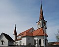
Catholic Church of St. German
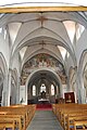
Interior of the St. German Church

Side altar of the Church of St. German


Web links
- Official website of the municipality of Gurmels
- Olivier Aebischer: Gurmels. In: Historical Lexicon of Switzerland .
- Aerial views of Gurmels
- Olivier Aebischer: Cordast. In: Historical Lexicon of Switzerland .
- Ursula Birchler: Guschelmuth. In: Historical Lexicon of Switzerland .
- Olivier Aebischer: Kleingurmels. In: Historical Lexicon of Switzerland .
- Hermann Schöpfer: Liebistorf. In: Historical Lexicon of Switzerland .
- Eveline Seewer: Monterschu. In: Historical Lexicon of Switzerland .
Individual evidence
- ↑ Permanent and non-permanent resident population by year, canton, district, municipality, population type and gender (permanent resident population). In: bfs. admin.ch . Federal Statistical Office (FSO), August 31, 2019, accessed on December 22, 2019 .
Gurwolf | Courtepin | Cressier | Fräschels | Galmiz | Gempenach | Greng | Gurmels | Kerzers | Kleinbösingen | Meyriez | Misery Courtion | Mont-Vully | Muntelier | Murten | Ried near Kerzers | Ulmiz . Former municipalities: Agriswil | Altavilla | Barberêche | Bas-Vully | Cans | Castle | Chandossel | Cordast | Cormérod | Corsalettes | Courlevon | Cournillens | Courtaman | Courtion | Coussiberlé | Grossgurmels | Grossguschelmuth | Guschelmuth | Haut-Vully | Jeuss | Small gurmel | Kleinguschelmuth | Liebistorf | Lurtigen | Misery | Monterschu | Salvenach | Villarepos | Wallenbuch | Wallenried .