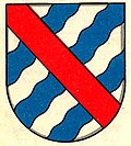
Wallenried FR
| FR is the abbreviation for the canton of Friborg in Switzerland and is used to avoid confusion with other entries of the name Wallenried . |
| Wallenried | ||
|---|---|---|
| State : |
|
|
| Canton : |
|
|
| District : | lake | |
| Municipality : | Courtepin | |
| Postal code : | 1784 | |
| former BFS no. : | 2283 | |
| Coordinates : | 575391 / 191438 | |
| Height : | 559 m above sea level M. | |
| Area : | 3.88 km² | |
| Residents: | 455 (December 31, 2016) | |
| Population density : | 117 inhabitants per km² | |
| Website: | www.courtepin.ch | |
|
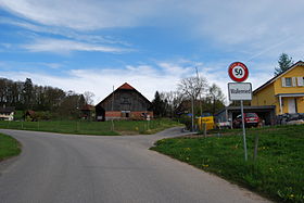
Entrance of Wallenried, coming from Villarepos |
||
| map | ||
|
|
||
Wallenried ( French: Esserts (Lac) ; Freiburger Patois ) was a political municipality in the lake district (French: District du Lac) of the canton of Friborg in Switzerland until December 31, 2016 . Despite the majority French-speaking population, the municipality officially has a German name. On January 1, 2017, Wallenried merged with the former municipalities of Barberêche and Villarepos to form the new municipality of Courtepin .
geography
Wallenried lies at 559 m above sea level. M. , six kilometers south of the district capital Murten (linear distance ). The village extends in a hollow in the headwaters of the Ruisseau des Echelles (right side stream of the Chandon ), in the Molasse hill country of the northern Freiburg Central Plateau .
The area of 3.9 square kilometers large municipal area comprises a portion of the glacial Rhonegletscher overmolded Molassehöhen between the Morat in the northwest and the Saanen valley in the east. The central part of the area is occupied by the wide basin of the Ruisseau des Echelles . This is in the south by the hills Epenay ( 577 m above sea level. M. ) and Zudalla (at 610 m above sea level. The highest point of Wallenried), in the east by the Bois de la Râpe ( 601 m above sea level ) and the Saddle to the Biberental , surrounded in the north by the height of the Oberholz . To the west, the valley of the brook gradually deepens into the molasse layers, with two other brooks flowing from the south, including that from the Creux-Maringou . In 1997, 13% of the municipal area was accounted for by settlements, 18% for forests and woodlands and 69% for agriculture.
A few individual farms belong to Wallenried. Neighboring communities of Wallenried are Murten , Cressier , Gurmels , Courtepin , Misery-Courtion and Villarepos .
population
With 455 inhabitants (as of December 31, 2016) Wallenried was one of the small communities in the canton of Friborg. 53.5% of the residents are French-speaking, 43.6% German-speaking and 0.6% speak Italian (as of 2000). The population of Wallenried amounted to 270 in 1900. In the course of the 20th century the population fluctuated between 240 and 300 inhabitants. Only since 1980 (244 inhabitants) has a significant increase in population been recorded.
economy
Until the second half of the 20th century, Wallenried was predominantly an agricultural village. Even today, arable farming , fruit growing and animal husbandry have an important place in the income structure of the population. Further jobs are available in local small businesses and in the service sector. Wallenried is the location of a golf course. In the last few decades the village has also developed into a residential community. Many employed people are therefore commuters who mainly work in the Freiburg and Murten regions.
traffic
The community is located away from the major thoroughfares, but is easily accessible from Courtepin . Wallenried is connected to the public transport network by TPF line 546 from Murten to Courtepin. Courtepin train station on the Freiburg - Murten railway line is around 1 km from the town center.
history
The first written mention of the place took place in 1337 under the name Essert . The German version of Ried has been handed down from 1498 . The village has been called Wallenried since the 17th century. Since the Middle Ages , Wallenried has formed a small lordship that has seen numerous changes of ownership over the years and passed to the Castella family in 1729.
In 1442 the village came under the rule of Freiburg through purchase and from then on belonged to the Old Landscape (Spitalpanner). After the collapse of the Ancien Régime (1798), Wallenried belonged to the Freiburg district during the Helvetic and the following period, and from 1831 to the German district of Freiburg before it was incorporated into the lake district in 1848 with the new cantonal constitution.
Attractions
The village and castle chapel was donated by Rodolphe de Castella in 1760 to thank him for his victory in Wesel . Wallenried Castle is a rectangular mansion built in the 18th century, which was rebuilt and enlarged in 1824.
literature
- Hermann Schöpfer: Les monuments d'art et d'histoire du Canton de Friborg, Tome IV: Le District du lac (I). Edited by the Society for Swiss Art History GSK. Bern 1989 (Art Monuments of Switzerland, Volume 81). ISBN 3-909158-21-8 . Pp. 413-431.


