Bas-Vully
| Bas-Vully | ||
|---|---|---|
| State : |
|
|
| Canton : |
|
|
| District : | lake | |
| Municipality : | Mont-Vully | |
| Postal code : | 1786 Sugiez 1788 Praz |
|
| former BFS no. : | 2280 | |
| Coordinates : | 575178 / 201259 | |
| Height : | 433 m above sea level M. | |
| Area : | 9.95 km² | |
| Residents: | 2098 (December 31, 2014) | |
| Population density : | 211 inhabitants per km² | |
| Website: | mont-vully.ch | |
|
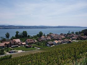
Praz (Vully) with the Murten lake |
||
| map | ||
|
|
||
Until December 31, 2015, Bas-Vully was a municipality in the lake district (French: District du Lac) of the canton of Friborg in Switzerland . Until 1977 the municipality was officially called Vully-le-Bas . The German names of the municipality used in the region are Niederwistenlach and Unterwistenlach . On January 1, 2016, Bas-Vully and Haut-Vully merged to form the new municipality of Mont-Vully .
geography
Bas-Vully with the center of Sugiez is 433 m above sea level. M. , 3.5 km north of the district capital Murten (linear distance). The village extends on the north shore of Lake Murten , near the outflow of the Broye Canal , at the southeastern foot of Mont Vully , in the northern Freiburg Central Plateau .
The area of the 10 km² former municipal area covers a section of the northern Freiburg Central Plateau in the Dreiseenland. The area has an approximately 2 km long lakeshore line on Lake Murten between Môtier in the west and the outflow of the Broye Canal in the east. From the lakeshore, the communal soil extends northward over an approximately 300 m wide flat edge of the bank to the Mont Vully, on the summit of which is 653 m above sea level. M. the highest point of Bas-Vully is reached. This mountain, consisting of molasse , has a plateau in the ridge area that gradually descends towards the south, before it descends with a steep slope towards Lake Murten. The plateau was subdivided over the course of millions of years by the erosion force of two streams and the valley systems of Vaux de Praz and Vaux de Nant were created. The north side of Mont Vully drops steeply to the wooded hillside La Roseire to the plane of the Great Marsh from.
The northern part of the municipality includes the 432 m above sea level. M. located agriculturally intensively used level of the Great Moos, which the Broye Canal flows through. To the east, the municipal area extends along the Grand Canal and Bibere Canal to Bellechasse , while the northern border runs along the edge of the so-called state forest . In 1997, 12% of the former municipal area was in settlements, 12% in forests and woodland, 73% in agriculture and around 3% was unproductive land.
Bas-Vully consists of the municipalities that merged on January 25, 1850:
- Sugiez , 433 m above sea level M. , at the eastern foot of Mont Vully and on both sides of the Broye Canal
- Nant , consisting of Nant-Dessous ( 433 m above sea level ) and Nant-Dessus ( 437 m above sea level ), both located between Lake Murten and the foot of Mont Vully at the exit of the Vaux de Nant valley system
- Praz , 434 m above sea level M. , on the plain between Lake Murten and Mont Vully, at the exit of the Vaux de Praz valley system
These three formerly independent communities have now grown together to form a long street village. Hereinafter also include Bellechasse ( 432 m above sea level. M. ) in the Great Marsh on Biberekanal and some isolated farms to Bas-Vully. Neighboring communities of Bas-Vully are Haut-Vully , Galmiz and an exclave of Murten in the canton of Friborg and Ins and Müntschemier in the canton of Bern .
population
With 2098 inhabitants (as of December 31, 2014), Bas-Vully was one of the medium-sized municipalities in the canton of Friborg. 58.6% of the residents are French-speaking, 30.4% German-speaking and 3.2% speak Portuguese (as of 2000). In recent years the proportion of the German-speaking population has increased steadily (only 23% German-speaking in 1990). The population of Bas-Vully was 1123 in 1850 and 1044 in 1900. After a peak in 1940 with 1595 inhabitants, the population decreased by almost 40% to 1004 people by 1980 due to strong emigration. Since then, the population has grown again significantly.
economy
Bas-Vully was mainly an agricultural village until the second half of the 20th century . Even today arable farming , vegetable growing and fruit growing have an important place in the income structure of the population. On the lower southern slope of Mont Vully and in the two erosion valleys, thanks to the optimal exposure to the sun, there is a contiguous wine-growing area (especially Chasselas grapes). Some residents also make a living from fishing.
Further jobs are available in local small businesses and in the service sector. In the villages there are garden centers, carpenters, locksmiths and wine shops. A larger commercial and industrial area has emerged east of the Broye Canal since the 1980s. Companies in the food processing, transport and construction industries as well as the electrical industry have settled here. The cantonal penal institution of Freiburg is located in Bellechasse.
In the last few decades, Bas-Vully has also developed into a residential community thanks to its attractive location. Many employees are therefore commuters, some of whom work in the immediate vicinity (Murten, Kerzers), but also in Neuchâtel and in the agglomeration of Bern because of the good transport links .
tourism
Bas-Vully also benefits from tourism thanks to its mild and beautiful location and the possibility of water sports on Lake Murten. Sugiez has a large campsite at the outflow of the Broye from the lake. A few more holiday homes are located along the lakeshore.
traffic
The former municipality is very well developed in terms of traffic. It is located on a connecting road from Salavaux along the northern shore of Lake Murten to Sugiez. The main road from Bern to Neuchâtel runs east of the Broye Canal . The nearest connection to the A1 motorway (Bern-Lausanne) is around 5 km from the town center. On May 1, 1903, the railway line from Murten to Ins was opened with a train station in Sugiez. The villages Sugiez, Nant and Praz are connected to the public transport network via a Postbus course that runs from Sugiez to Lugnorre, but only Monday to Friday. Praz and Sugiez have a connection with the other Seeanstösser communities through the passenger shipping on Lake Murten (there is also a direct connection with Lake Neuchâtel via the Broyekanal ).
history
The municipality of Bas-Vully was settled very early, which is confirmed by the remains of a Celtic oppidum on Mont Vully. The place was first mentioned in a document in 968 under the name Wisliacense . Later, the names Vuisliacense (985), Williex (1192), Willie (1228), Villiaco , Wistillacho (1266), Williey (1330), Vuillie (1334), Wuilliacum and Vuilliez (1453). The name Vully goes back to a Gallo-Roman settler named Vistilius . Bas-Vully was known as Commune générale des quatre villages de La Rivière until 1831 . In addition to Sugiez, Praz and Nant, there was also the village of Chaumont ( Ger . Zöumet ), which was abandoned in 1859 after a landslide.
The villages of Praz, Nant, Sugiez and Chaumont on the north shore of Lake Murten were also referred to as La Rivière by the liege lord Murten . The spelling Ripperia is also found in three documents from 1443 . This meant an administrative unit rather than a municipality in today's sense.
Since 1375 the villages of today's Bas-Vully municipality belonged to the Murten domain. From 1484 they were subordinate to the Landvogtei Murten, jointly administered by the estates of Bern and Freiburg. After the collapse of the Ancien Régime (1798), the villages came to the canton of Friborg and belonged to the Murten district during the Helvetic and the following period, before they were incorporated into the lake district with the new cantonal constitution in 1848.
The final amalgamation of Sugiez, Nant and Praz, who had their own village administrations until 1798, but subsequently carried out certain tasks together, took place on January 25, 1850. The community does not have its own church, since 1530 it has belonged to the Reformed parish of Môtier. During the First World War , some fortifications were built in the sandstone of Mont Vully. In 2003, a merger of the municipalities of Bas-Vully and Haut-Vully was up for discussion, but this failed due to the rejection of the voters of Bas-Vully (50 votes).
On January 1, 2016, the two municipalities of Bas-Vully and Haut-Vully merged to form the new municipality of Mont-Vully.
Attractions
Sugiez as well as Nant and Praz have characteristic wine and arable farmhouses from the 17th to 19th centuries. Particularly noteworthy is a group of houses in Praz with the Chervet House (16th century) and the Burnier House (18th century) with a portal dating from 1573. The foundations of the Tour des Sarrasins, a fortification tower from the 12th or 13th century, are visible on a promontory over the Vaux de Nant.
A wine-growing nature trail (Sentier viticole du Vully) leads along the vineyards around 50 m above the lake level of Lake Murten, with a beautiful view of the wine-growing villages of Bas-Vully and, on a clear day, to the Alps.
The well-known artist and iron sculptor Bernhard Luginbühl has exhibited some of his most important and largest works of art in the Hotel de la Gare in Sugiez . In addition, the "Bar des artistes" in the same hotel was designed by him and is a popular meeting place for the residents. The bar ceased operations in 2013.
literature
- Hermann Schöpfer: Les monuments d'art et d'histoire du Canton de Friborg, Tome IV: Le District du lac (I). Edited by the Society for Swiss Art History GSK. Bern 1989 (Art Monuments of Switzerland, Volume 81). ISBN 3-909158-21-8 . Pp. 359-412.
Web links
- Official website of the municipality of Bas-Vully (French)
- Marianne Rolle: Bas-Vully. In: Historical Lexicon of Switzerland .
- Marianne Rolle: Chaumont. In: Historical Lexicon of Switzerland .
- Marianne Rolle: Nant. In: Historical Lexicon of Switzerland .
- Aerial photos of Sugiez
- Aerial view of Nant
- Aerial photography of Praz (Vully)
- Bar des Artistes, Sugiez
Individual evidence
- ↑ Hermann Schöpfer: Les Monuments d'Art et d'Histoire du Canton de Friborg Tome IV. Le Distric du Lac (I) Volume 81 of the series Kunstdenkmäler der Schweiz, Édition Wiese SA Bâle 1989 ISBN 3-909158-21-8 . Page 359.
- ↑ Mont-Vully communal notice number 1 PDF


