
Gurwolf
| Gurwolf Courgevaux |
|
|---|---|
 |
|
| State : |
|
| Canton : |
|
| District : | lake |
| BFS no. : | 2250 |
| Postal code : | 1796 |
| Coordinates : | 575 110 / 195207 |
| Height : | 475 m above sea level M. |
| Height range : | 443–557 m above sea level M. |
| Area : | 3.38 km² |
| Residents: | 1420 (December 31, 2018) |
| Population density : | 420 inhabitants per km² |
| Website: | www.courgevaux.ch |
_407.JPG) Entrance to Gurwolf |
|
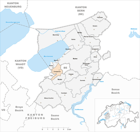
| Location of the municipality | |
  |
|
Gurwolf , French Courgevaux ( Freiburger Patois ), is a municipality in the lake district ( French : District du Lac ) in the Swiss canton of Friborg .
geography
Gurwolf lies at 475 m above sea level. M. , 2.5 km south of the district capital Murten (linear distance). The clustered village extends in a wide hollow, through which the Dorfbach flows, at the northwestern foot of the Boulary forest height, in the northern Freiburg Central Plateau .
The area of the 3.4 km² large municipal area includes a section of the heights south of the Murtensee , a drumlin landscape that was formed by the Ice Age Rhone glacier . The central part of the area forms the basin of Gurwolf, which extends from the hill Les Vignes ( 513 m above sea level ) to the north, from Beney ( 513 m above sea level ) in the south-west and from the Boulary forest height (the municipality area ) in the south-east only up to the Bircherwald ) is flanked. North of Les Vignes, the area extends into the southern industrial zones of Murten. To the west, the communal soil extends to the plateau of Le Chaney and the Les Marais valley near Clavaleyres. A narrow tip extends to the southwest and includes the forest slope Besseire, on which 556 m above sea level. M. the highest point of Gurwolf is reached. In 1997, 15% of the municipal area was accounted for by settlements, 23% for forests and woodlands and 62% for agriculture.
Gurwolf includes the new building quarter on the Les Vignes hill, part of the commercial zone of Murten and some individual farms. Gurwolf's neighboring municipalities are Murten , Greng and Villarepos in the canton of Friborg, Münchenwiler and Clavaleyres in the canton of Bern and Faoug in the canton of Vaud .
population
With 1420 inhabitants (as of December 31, 2018) Gurwolf is one of the medium-sized communities in the canton of Friborg. The population was 169 in 1811 and 490 in 1900. After that there was a population decrease until 1940 (384 inhabitants). Since then there has been a significant increase in population, especially during the 1960s and since 1980 (662 inhabitants).
languages
56.5% of the residents are German-speaking, 40.1% French-speaking and 4.0% speak Portuguese (as of 2000). In the originally French-speaking village, the linguistic majorities changed during the 1990s due to the influx of German-speaking residents.
economy
Gurwolf was a predominantly agricultural village until the middle of the 20th century . Today agriculture , fruit growing and cattle breeding have only a minor role in the income structure of the population. Further jobs are available in local small businesses and in the service sector. Since the 1960s, businesses have settled in the far north of Gurwolf at the Murten bypass. There are companies in the building trade, horticulture, mechanical engineering (agricultural machinery and equipment), fireplace construction, a distillery and various small businesses represented. From 1945 to 2003 Rastawerk AG worked in Gurwolf, which produced grinding stones and cutting discs. In the last few decades the village has also developed into a residential community. Many employed people are therefore commuters who mainly work in the Murten and Freiburg regions.
traffic
The community is very well developed in terms of transport. It is located on the main road from Freiburg to Murten . The closest connection to the A1 motorway (Bern-Lausanne) is around 4 km from the town center. The motorway, opened in 1997, crosses under the hill of Les Vignes in an approximately 2.2 km long tunnel. On August 23, 1898, the railway line from Murten to Freiburg was put into operation. The Münchenwiler-Courgevaux train station is located on the municipality of Münchenwiler, around 700 m from Gurwolf.
history
The municipality of Gurwolf was settled early on, which could be proven by means of traces of settlement from the Bronze Age and the remains of a Roman brick kiln.
The first written mention of the place took place in 1055 under the name Corgivul . Later the names Curgivol (1080), Curgevolt (1142), Corgivolt (1173), Corgevoulx (1558), Gurwolf and Curwolf (1578), Cur Wolff (1668) appeared. The Courgevaud spelling was also used until the beginning of the 20th century . The place name is a combination of corte "Hof" with the Old High German personal name Gibuld or Gebawalt (the personal name Giwulf suggested in older place name research is not possible for reasons of sound) and means Hof des Gibuld or Hof des Gebawalt . The corte names are typical of the settlements that arose in the 6th century AD. The German -wolf is a folk etymology based on the animal name wolf , which also appears in the municipality's coat of arms.
A noble family von Gurwolf has been mentioned since the 11th century. Local rule passed to Humbert de Praroman in 1529 and to the Diesbach family in 1722 . The Gurwolf rule was under the rule of Murten during the Savoy era. In 1475, the village came under the joint administration of the estates of Bern and Freiburg as part of the bailiwick of Murten. After the collapse of the Ancien Régime (1798) Gurwolf came to the canton of Friborg. During the Helvetic Republic and the following period it belonged to the Murten district before it was incorporated into the lake district in 1848 with the new cantonal constitution.
Attractions
The Gurwolf Castle of the Diesbach-Torny family was built in 1685 and expanded in 1797. The Herrenschwand family's country estate also dates from the end of the 17th century. The village does not have its own church, it belongs to the parish of Merlach.
photos

Gurwolf municipal administration

village street

Village center
_413.JPG)
_417.JPG)
_410.JPG)
literature
- Marianne Rolle: Gurwolf. In: Historical Lexicon of Switzerland .
- Hermann Schöpfer: Les monuments d'art et d'histoire du Canton de Friborg, Tome IV: Le District du lac (I). Edited by the Society for Swiss Art History GSK. Bern 1989 (Art Monuments of Switzerland, Volume 81). ISBN 3-909158-21-8 . Pp. 93-112.
Web links
Individual evidence
- ↑ Permanent and non-permanent resident population by year, canton, district, municipality, population type and gender (permanent resident population). In: bfs. admin.ch . Federal Statistical Office (FSO), August 31, 2019, accessed on December 22, 2019 .
- ↑ Lexicon of Swiss municipality names . Edited by the Center de Dialectologie at the University of Neuchâtel under the direction of Andres Kristol. Frauenfeld / Lausanne 2005, p. 270 f.
Gurwolf | Courtepin | Cressier | Fräschels | Galmiz | Gempenach | Greng | Gurmels | Kerzers | Kleinbösingen | Meyriez | Misery Courtion | Mont-Vully | Muntelier | Murten | Ried near Kerzers | Ulmiz . Former municipalities: Agriswil | Altavilla | Barberêche | Bas-Vully | Cans | Castle | Chandossel | Cordast | Cormérod | Corsalettes | Courlevon | Cournillens | Courtaman | Courtion | Coussiberlé | Grossgurmels | Grossguschelmuth | Guschelmuth | Haut-Vully | Jeuss | Small gurmel | Kleinguschelmuth | Liebistorf | Lurtigen | Misery | Monterschu | Salvenach | Villarepos | Wallenbuch | Wallenried .