Guschelmuth
| Guschelmuth | ||
|---|---|---|
| State : |
|
|
| Canton : |
|
|
| District : | lake | |
| Municipality : | Gurmels | |
| Postal code : | 1792 | |
| former BFS no. : | XXXX | |
| Coordinates : | 576855 / 192 174 | |
| Height : | 581 m above sea level M. | |
| Residents: | 327 (2002) | |
|
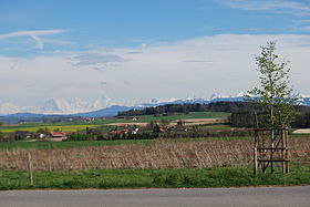
Kleinguschelmuth, seen from the St. Urban Chapel |
||
| map | ||
|
|
||
Guschelmuth ( French Courchelmont ; Freiburger Patois ) used to be an independent political municipality in the lake district (French: District du Lac) of the canton of Friborg in Switzerland . On 1 January 2003, together with Guschelmuth Liebistorf and Wallenbuch after Gurmels incorporated. It consists of the two districts Grossguschelmuth and Kleinguschelmuth , which until 1977 formed two separate communities.
geography
Guschelmuth is 581 m above sea level. M. , three kilometers west-southwest of Gurmels and five and a half kilometers south of the district capital Murten (as the crow flies). Grossguschelmuth extends on the gently sloping western slope of the height Lengi Zelg with the Bouleywald , above the valley of the beavers . The street village of Kleinguschelmuth is 566 m above sea level. M. on the north slope of the Lengi Zelg , which slopes slightly towards the Biberental , north of the Bouleywald . The former municipality area was around 3.1 km². The area comprised a section of the Molasse heights in the northern Freiburg Central Plateau with the headwaters of the Biberen. It reached to the southeast on the Lengi Zelg ridge ( 610 m above sea level ) and to the west over the Grupiliri forest ( 582 m above sea level ) and the Biberen valley to the foot of the Oberholz .
population
With 327 inhabitants (2002), Guschelmuth was one of the small communities in the canton of Friborg before the merger. In 1850 the community had 186 inhabitants, in 1900 222 inhabitants. The residents are predominantly German-speaking.
economy
Guschelmuth was a predominantly agricultural village until the second half of the 20th century . Even today, arable farming , fruit growing and animal husbandry have an important place in the income structure of the population. Further jobs are available in local small businesses and in the service sector, including in a carpenter's workshop and in a switchgear manufacturing company. In the last few decades the village has also developed into a residential community. Many employed people are therefore commuters who mainly work in the Freiburg and Murten regions.
traffic
The village is located away from the larger thoroughfares, but is easily accessible from the main road Murten - Freiburg or from Gurmels. Guschelmuth is poorly connected to public transport; Between Gurmels and Courtepin some TPF buses run Monday to Friday (4 courses).
history
The area of Guschelmuth was settled very early, which could be proven on the basis of a grave from the Hallstatt period discovered west of Kleinguschelmuth and fragments of Roman bricks. The first written mention of the place took place in 1285 under the name Cursilimuot . Later, the names Gursalamut (1363), Cuffermuot (1414) and Cursilmut (1442) appeared.
Guschelmuth had been in the possession of the Counts of Thierstein since the Middle Ages , after which it came to the Freiburg Citizens Hospital. In 1442 the village came under the rule of Freiburg through purchase and from then on belonged to the Old Landscape (Spitalpanner). After the collapse of the Ancien Régime (1798), Guschelmuth belonged to the Murten district during the Helvetic Republic, to the Freiburg district from 1803 and to the German district of Freiburg from 1831, before it was incorporated into the lake district in 1848 with the new cantonal constitution.
Grossguschelmuth and Kleinguschelmuth had had a joint municipal administration since 1865 (with separate cash management). This close cooperation resulted in the merger of the two villages on January 1, 1978, with the new municipality being named Guschelmuth.
As part of the community mergers that the canton of Friborg has sponsored since 2000, the village population unanimously decided on June 28, 2002 to merge with the neighboring community of Gurmels. With effect from January 1, 2003, Guschelmuth was therefore incorporated into Gurmels .
Attractions
The Grossguschelmuth chapel was consecrated to John the Baptist in 1801 and restored in 1990. Guschelmuth belongs to the parish of Gurmels. In the center of Gross- und Kleinguschelmuth some characteristic farmhouses from the early 18th century have been preserved.
Web links
- Official website of the municipality of Gurmels
- Ursula Birchler: Guschelmuth. In: Historical Lexicon of Switzerland .
- Website about Guschelmuth
Individual evidence


