
Barberêche
| Barberêche | ||
|---|---|---|
 |
||
| State : |
|
|
| Canton : |
|
|
| District : | lake | |
| Municipality : | Courtepin | |
| Postal code : | 1783 | |
| former BFS no. : | 2243 | |
| Coordinates : | 578688 / 189604 | |
| Height : | 569 m above sea level M. | |
| Area : | 9.13 km² | |
| Residents: | 544 (December 31, 2016) | |
| Population density : | 60 inhabitants per km² | |
| Website: | www.courtepin.ch | |
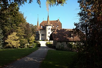
 Barbareche Castle |
||
| map | ||
|
||


Barberêche ( Freiburger Patois ) was a municipality in the District du Lac (German: Seebezirk) in the canton of Friborg in Switzerland until December 31, 2016 . The village on the linguistic border bears the German name Bärfischen . On January 1, 2017, Barberêche merged with the former municipalities of Villarepos and Wallenried to form the new municipality of Courtepin .
geography
Barberêche is 569 m above sea level. M. , 5.5 km north of the canton capital Friborg (beeline). The scattered settlement community extends from a panoramic location on a terrace north of the Schiffenensee through which the Saane flows , at the foot of the hill of the Grand Bois , in the Freiburg Central Plateau .
The 9.1 km² municipal area covers a section of the Molasse hill country in the Freiburg Central Plateau. The elongated but narrow area is bounded in the southeast by the Schiffenensee. This reservoir has a 20 to 50 m high wooded steep bank, which is partly criss-crossed by sandstone cliffs , over almost the entire length of the municipality of Barberêche . Several short erosion troughs flow into the lake , the lowest area of which was flooded by the damming up of the water. The valleys subdivide the Barberêche terrace into different plateaus, which are connected to the Molasse hills in the northwest.
In the extreme south and southwest the area of the municipality extends over the valley of Courtepin to the flat confluence of the Sonnaz brook into the Schiffenensee. To the west of it the area extends into the Bois de la Corbaz (up to 650 m above sea level ) and to the edge of the forest of the Bois de l'Hôpital ( 660 m above sea level ). To the northeast, the municipality extends over the height of Breilles (at 668 m above sea level, the highest point of Barberêche), the forest of Bouley and the Grand Bois and the Bulliardholz (up to 660 m above sea level ) to the foot of large wood in small gurgles . In 1997, 5% of the municipal area was in settlements, 21% in forests and woodlands, 60% in agriculture and around 14% was unproductive land (lake area).
Barberêche consists of several settlements, namely:
- the actual village of Barberêche ( 569 m above sea level )
- the village of Pensier (German: Penzers), 584 m above sea level. M. , above the confluence of the Sonnaz in the Schiffenensee
- the hamlet of Hobelet ( Eng .: Hubel), 655 m above sea level. M. , at the height above Pensier,
- the hamlet of Villaret , 610 m above sea level. M. , above the valley of Courtepin,
- the hamlet of Breilles ( Ger .: Brigels), 640 m above sea level. M. , on the edge of the bouley,
- the hamlet of Petit Vivy (German: Klein-Vivers), 590 m above sea level. M. , on the terrace above the Schiffenensee east of the Grand Bois
- the hamlet of Grand Vivy (German: Gross-Vivers), 565 m above sea level M. , on the terrace above the Schiffenensee east of the Bulliardholz
- the hamlet of Grimoine ( Ger .: Courmoen), 565 m above sea level. M. , on the terrace above the Schiffenensee south of Kleingurmels.
The neighboring communities of Barberêche are La Sonnaz , Misery-Courtion , Courtepin , Gurmels and Düdingen .
population
With 544 inhabitants (as of December 31, 2016), Barberêche was one of the smaller communities in the canton of Friborg. The focus of the settlement is Pensier with around 250 inhabitants, around 100 people live in the village of Barberêche. The population of Barberêche was 389 in 1850 and 507 in 1900. After a peak in 1960 with 674 inhabitants, the population decreased by over 25% to 499 people by 1980 due to strong emigration. Since then, a slight increase in population has been recorded.
languages
74.2% of the residents are French-speaking, 21.8% German-speaking and 1.3% speak Portuguese (as of 2000). The residents of the community spoke almost exclusively German until the 15th century. After that, the French-speaking portion slowly increased and the village was bilingual in the 18th and 19th centuries. French speakers have been in the majority since around 1860.

economy
Barberêche was a predominantly agricultural village until the second half of the 20th century . Even today, arable farming , fruit growing and animal husbandry have an important place in the income structure of the population. Further jobs are available in local small businesses and in the service sector. There is a business park at Pensier. Until 1976, Barberêche was the location of a boarding school (Institut Saint-Dominique). In the last few decades the village has also developed into a residential community. Many workers are therefore commuters who mainly work in the Freiburg region.
traffic
The community is very well developed in terms of traffic, although it is away from the major thoroughfares. The closest connection to the A12 motorway (Bern-Vevey) is around 5 km from the town center. On August 23, 1898, the railway line from Freiburg to Murten was opened with a train station in Pensier. The village of Barberêche itself has no connection to the public transport network.
history

The municipality of Barberêche was settled very early on, which has been proven by the discovery of graves from the Hallstatt period and the foundations of second Roman manors.
The place was first mentioned in a document in 1154 under the name Barbereschi . Later, the names Barberesche (1173), Barbaresche (1180), Barbareschi (1182) and Barbarica (1423) appeared. The place name goes back to the surname Barbar (i) us .
A noble family from Barberêche has been documented since the 12th century. The Barberêche reign was initially under the Dukes of Zähringen , then came as a fief to the Counts of Thierstein , before there were numerous changes of ownership since the 15th century. In 1442 Barberêche came to the old landscape of Freiburg (Spitalpanner). After the collapse of the Ancien Régime (1798), the village belonged to the Freiburg district during the Helvetic and the following period and to the German district of Freiburg from 1831, before it was incorporated into the lake district in 1848 with the new cantonal constitution. Barberêche is the seat of the de Zurich patrician family .
Attractions
The core of the parish church of Saint-Maurice dates back to the 11th century. It was enlarged in 1785–1786 and rebuilt again in the 19th century and has a choir with a semicircular apse and blind arcades in the early medieval style. The interior of the church contains wall paintings from the 18th century, wood carvings and coats of arms (stained glass). The rectory next to the church dates from 1566.
On the edge of the plateau, directly above the Schiffenensee, the Barberêche Castle rises. It was built between 1552 and 1528, probably on the site of an older fortification under Petermann de Praroman, in the late Gothic style. Extensive renovations were carried out from 1839 to 1844, whereby the castle was given its current appearance in neo-Gothic and neoclassical styles . Today the castle is privately owned.
The Petit-Vivy Castle is also located north-east of Barberêche above the steep bank of the Schiffenensee. It is one of the oldest preserved castles in the region. The mighty square keep, still preserved today, dates from the second half of the 13th century and has walls up to 3.5 m thick. Remains of the former ring walls in the shape of a triangle are visible around the keep. The residential buildings were built in the 16th century.
Even further to the north-east is the Grand-Vivy Castle on a narrow ledge between the Schiffenensee and a left side stream. A castle has stood here since the Middle Ages, but it was replaced in 1616 by today's late Gothic castle with a semicircular stair tower and another tower. The castle chapel next to it dates from the 19th century.

Pensier, municipality of Barberêche
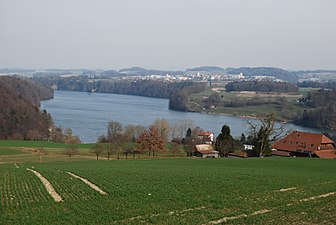
The Schiffenensee near Pensier

Chapel of St. Antoine in Pensier
Grand Vivy Castle

Petit-Vivy Castle
_001.JPG)
_052.JPG)
_043.JPG)


Personalities
Joseph Deiss , politician, Federal Councilor and 2010/11 President of the UN General Assembly . Former mayor of Barberêche.
literature
- Hermann Schöpfer: Les monuments d'art et d'histoire du Canton de Friborg, Tome IV: Le District du lac (I). Edited by the Society for Swiss Art History GSK. Bern 1989 (Art Monuments of Switzerland, Volume 81). ISBN 3-909158-21-8 . Pp. 86-90.
Web links
- Official website of the municipality of Barberêche
- Marianne Rolle: Barberêche. In: Historical Lexicon of Switzerland .
- Aerial views of Barberêche
- Petit-Vivy Castle (French)
- Grand Vivy Palace (French)
Gurwolf | Courtepin | Cressier | Fräschels | Galmiz | Gempenach | Greng | Gurmels | Kerzers | Kleinbösingen | Meyriez | Misery Courtion | Mont-Vully | Muntelier | Murten | Ried near Kerzers | Ulmiz . Former municipalities: Agriswil | Altavilla | Barberêche | Bas-Vully | Cans | Castle | Chandossel | Cordast | Cormérod | Corsalettes | Courlevon | Cournillens | Courtaman | Courtion | Coussiberlé | Grossgurmels | Grossguschelmuth | Guschelmuth | Haut-Vully | Jeuss | Small gurmel | Kleinguschelmuth | Liebistorf | Lurtigen | Misery | Monterschu | Salvenach | Villarepos | Wallenbuch | Wallenried .