
Cressier FR
| FR is the abbreviation for the canton of Friborg in Switzerland and is used to avoid confusion with other entries of the name Cressier . |
| Cressier | |
|---|---|
 |
|
| State : |
|
| Canton : |
|
| District : | lake |
| BFS no. : | 2257 |
| Postal code : | 1785 |
| Coordinates : | 577 265 / 194 148 |
| Height : | 569 m above sea level M. |
| Height range : | 526–630 m above sea level M. |
| Area : | 4.17 km² |
| Residents: | 1002 (December 31, 2018) |
| Population density : | 240 inhabitants per km² |
| Website: | www.cressier.ch |
.jpg) Cressier FR |
|
| Location of the municipality | |
  |
|
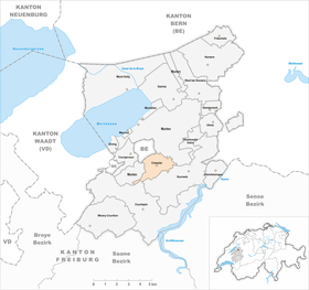
Cressier ( Freiburger Patois ) is a municipality in the District du Lac (German: Seebezirk) in the canton of Friborg in Switzerland . The German name Grissach is rarely used today.
geography
Cressier lies at 569 m above sea level. M. , 4 km southeast of the district capital Murten (linear distance). The village extends in a promising location on a plateau east of the Boulay forest, above the valley of the Biberen (French: La Bibera), in the Molasse heights in the northern Freiburg Central Plateau .
The area of the 4.2 km² large municipal area comprises a section of the molasse heights between Lake Murten and the Saane Valley, shaped by the Ice Age Rhone Glacier . The central part of the municipality is occupied by the plateau of Cressier. This plateau is bounded in the south by the up to 500 m wide valley low of the Biberen, in the east by the plain of the Jeussfeld . Beyond the beavers, the Bois des Planches forest below Guschelmuth still belongs to Cressier. To the west, the municipality extends to the forest height Boulary , which is 630 m above sea level. M. forms the highest point of Cressier. A narrow strip extends to the southwest along the left slope of the Biberen valley ( Bois de Palud ) to the Oberholz (up to 620 m above sea level ). In 1997, 8% of the municipal area was accounted for by settlements, 19% for forests and woodlands and 73% for agriculture.
The industrial area at the train station and some individual courtyards belong to Cressier. Neighboring communities of Cressier are Gurmels , Courtepin and Murten in the canton of Friborg and Münchenwiler in the canton of Bern .
population
With 1002 inhabitants (as of December 31, 2018), Cressier is one of the smaller communities in the canton of Friborg. The population of Cressier was 326 in 1850 and 350 in 1900. After that, the population fluctuated between 370 and 400 inhabitants until 1950. Since then, there has been significant population growth, particularly during the 1980s and 1990s.
languages
54.1% of the residents are French-speaking, 40.1% German-speaking and 1.9% speak Portuguese (as of 2000). Cressier is still mostly French-speaking today, although the proportion of the German-speaking population has increased in recent years. With the exception of Wallenried (in the southwest), the village is surrounded by predominantly German-speaking communities. House inscriptions indicate that Cressier was bilingual from the 17th to the beginning of the 19th century. Afterwards, however, the French had regained the upper hand.
economy
Until the middle of the 20th century, Cressier was a predominantly agricultural village. Today agriculture , fruit growing and cattle breeding have only a minor role in the income structure of the population. Further jobs are available in local small businesses and in the service sector. Since the 1960s, larger businesses have settled in the valley of the Biberen near the train station and at the eastern foot of the plateau on Pra Rond. The most important employer is currently the DiaMed group (medical technology). There are also other companies that specialize in the manufacture of pumps, X-ray systems, the construction industry, horticulture and the wine trade. In the last few decades the village has also developed into a residential community thanks to its attractive location. Many employed people are therefore commuters who mainly work in the Freiburg and Murten regions.
traffic
The community is very well developed in terms of transport. It is located near the main road from Murten to Düdingen . The closest connection to the A1 motorway (Bern-Lausanne) is around 7 km from the town center. On August 23, 1898, the railway line from Murten to Freiburg with a train station in Cressier was put into operation.
history
The municipality of Cressier was settled very early. Traces of settlement from the Bronze Age and burial mounds from the Hallstatt Age were found . The first written mention of the place took place in 1080 under the name Crissey . Later the names Crissiei (1172), Crissie (1182), Cressier (1243), the German Grissacho (1249), Crissye (1285) and Grissachen (1558) appeared. The place name goes back to the Gallo-Roman personal name Crisc (i) us .
From the 12th century onwards, Cressier had its own small lordship that belonged to the Counts of Thierstein as a fief. The village came under the rule of Freiburg through purchase in 1442 and was henceforth part of the old landscape (Spitalpanner). After the collapse of the Ancien Régime (1798), Cressier belonged to the district of Freiburg during the Helvetic and the following period and from 1831 to the German district of Freiburg, before it was incorporated into the lake district in 1848 with the new cantonal constitution.
Attractions
The core of the Catholic parish church in Cressier dates back to the 12th century. The church of Saint-Jean-Baptiste was given its current appearance when it was rebuilt in the classicist style between 1841 and 1844. The furnishings are partly from the previous building, including statues and oil paintings from the 17th and 18th centuries.
To the north of the church is the castle, which was built in a country house style in 1665 on the site of a former castle of the Lords of Cressier. The building was redesigned in the 18th and 19th centuries and extensively restored after a fire in 1974. The rich painting of the walls and ceilings in the small and large hall of the castle is remarkable.
In the center of Cressier there are some characteristic farmhouses from the 17th to 19th centuries. At the height to the west of the village is the Saint-Urbain chapel, which dates back to the 15th century and was renovated in 1697.

Catholic Church

Interior of the church

Manoir de Reynold
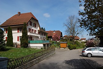
village street
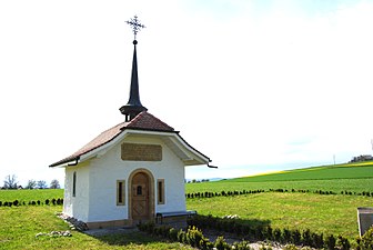
St. Urbain Chapel
_368.JPG)
_370.JPG)
_366.JPG)
_383.JPG)
_386.JPG)
literature
- Hermann Schöpfer: Les monuments d'art et d'histoire du Canton de Friborg, Tome IV: Le District du lac (I). Edited by the Society for Swiss Art History GSK. Bern 1989 (Art Monuments of Switzerland, Volume 81). ISBN 3-909158-21-8 . Pp. 163-202.
Web links
- Official website of the municipality of Cressier (FR)
- Marianne Rolle: Cressier (FR). In: Historical Lexicon of Switzerland .
- Aerial views of the village
Individual evidence
- ↑ Permanent and non-permanent resident population by year, canton, district, municipality, population type and gender (permanent resident population). In: bfs. admin.ch . Federal Statistical Office (FSO), August 31, 2019, accessed on December 22, 2019 .
Gurwolf | Courtepin | Cressier | Fräschels | Galmiz | Gempenach | Greng | Gurmels | Kerzers | Kleinbösingen | Meyriez | Misery Courtion | Mont-Vully | Muntelier | Murten | Ried near Kerzers | Ulmiz . Former municipalities: Agriswil | Altavilla | Barberêche | Bas-Vully | Cans | Castle | Chandossel | Cordast | Cormérod | Corsalettes | Courlevon | Cournillens | Courtaman | Courtion | Coussiberlé | Grossgurmels | Grossguschelmuth | Guschelmuth | Haut-Vully | Jeuss | Small gurmel | Kleinguschelmuth | Liebistorf | Lurtigen | Misery | Monterschu | Salvenach | Villarepos | Wallenbuch | Wallenried .