
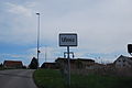
Ulmiz
| Ulmiz | |
|---|---|
 |
|
| State : |
|
| Canton : |
|
| District : | lake |
| BFS no. : | 2278 |
| Postal code : | 3214 |
| Coordinates : | 581 912 / 197962 |
| Height : | 494 m above sea level M. |
| Height range : | 483–555 m above sea level M. |
| Area : | 2.84 km² |
| Residents: | 441 (December 31, 2018) |
| Population density : | 155 inhabitants per km² |
| Website: | www.ulmiz.ch |
_251.JPG) Ulmiz parish hall |
|
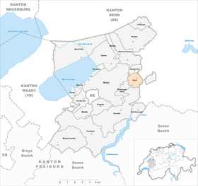
| Location of the municipality | |
  |
|
Ulmiz is a municipality in the lake district (French: District du Lac) in the canton of Friborg in Switzerland . The French name of the municipality is Ormey .
geography
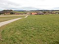
Ulmiz is 494 m above sea level. M. , 7 km east of the district capital Murten (linear distance). The cluster village extends in the valley basin of the Biberen , in the Molasse hill country of the northern Freiburg Central Plateau .
The area of 2.9 square kilometers large municipal area comprises a portion of the glacial Rhonegletscher overmolded Molassehöhen between the Great Marsh in the northwest and the Saanen valley in the east. The area is crossed from south to north by the Biberen in a shallow valley basin. To the east of the valley, the community area extends to the heights of the Wannerenwald , Chrüzfeld , Hubel and Eigen (all around 530 m above sea level ); in the south the fir wood also belongs to Ulmiz. To the west, the municipality extends to the adjacent plateau of the Galmfeld (at 555 m above sea level, the highest point of Ulmiz), to the edge of the Galmwald and into the Berleidwald ( 552 m above sea level ). The north-western border runs in the valley of the village stream of Lurtigen. In 1997, 6% of the municipal area was accounted for by settlements, 25% for forests and woodlands and 69% for agriculture.
The southern part of the hamlet of Chäppelimatt and some individual farms belong to Ulmiz. Neighboring communities of Ulmiz are Gempenach , Murten , Gurmels and the state forest Galm in the canton of Friborg and Kriechenwil and Ferenbalm in the canton of Bern .
population
With 441 inhabitants (as of December 31, 2018), Ulmiz is one of the small communities in the canton of Friborg. 96.7% of the residents are German-speaking, 2.5% French-speaking and 0.3% speak Albanian (as of 2000). The population of Ulmiz was 420 inhabitants in 1900. In the course of the 20th century, the population decreased by almost 40% to 262 people by 1980 due to strong emigration. Since then, the population has grown again significantly.
economy
Up until the second half of the 20th century, Ulmiz was a predominantly agricultural village. Even today, arable farming , fruit growing and animal husbandry have an important place in the income structure of the population. Further jobs are available in local small businesses and in the service sector, including in a process engineering company and in a furniture and sports shop. In the last few decades the village has also developed into a residential community. Many employed people are therefore commuters who mainly work in the Murten and Kerzers regions and in the Bern agglomeration .
traffic
The community is well developed in terms of traffic, although it is located away from the larger thoroughfares on a connecting road from Kerzers to Gurmels . The nearest connection to the A1 motorway (Bern-Lausanne) is around 5 km from the town center. Ulmiz is connected to the public transport network through the Postbus course , which runs from Kerzers to Düdingen .
history
The first documentary mention of the place took place in 1200 as Hulmeis , in 1250 it was mentioned under the name Ulmitz in the meaning of Ulmenhain . Ormei's French version has survived from 1390 . Since the Middle Ages Ulmiz belonged to the rule of Murten, which was under Savoy suzerainty. In 1475, the village came under the joint administration of the estates of Bern and Freiburg as part of the bailiwick of Murten. On the evening of June 21, 1476, the day before the battle of Murten , the Confederates set up camp at Ulmiz for the night.
After the collapse of the Ancien Régime (1798), Ulmiz came to the canton of Friborg. During the Helvetic Republic and the following period it belonged to the Murten district before it was incorporated into the lake district in 1848 with the new cantonal constitution.
In 1926 a stone meteorite weighing 76.5 grams fell near Ulmiz and was classified as L- chondrite .
Attractions
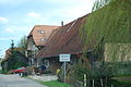
Ulmiz has a well-preserved townscape with characteristic houses from the 17th to 19th centuries. This includes the tavern, the school house, the cheese dairy and the oven house. The former church of Ulmiz was demolished in the middle of the 18th century. Today the parish belongs to the parish Ferenbalm.
Ulmiz from the west
Entrance to Chäppelimatt
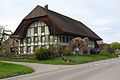
Half-timbered house in the center of Ulmiz

Old houses in the center of Ulmiz

_237.JPG)
_235.JPG)
_244.JPG)
_239.JPG)
Web links
- Official website of the Ulmiz municipality
- Hans Herren: Ulmiz. In: Historical Lexicon of Switzerland .
Individual evidence
- ↑ Permanent and non-permanent resident population by year, canton, district, municipality, population type and gender (permanent resident population). In: bfs. admin.ch . Federal Statistical Office (FSO), August 31, 2019, accessed on December 22, 2019 .
- ↑ Ulmiz. Meteoritical Bulletin, accessed June 30, 2020 .
Gurwolf | Courtepin | Cressier | Fräschels | Galmiz | Gempenach | Greng | Gurmels | Kerzers | Kleinbösingen | Meyriez | Misery Courtion | Mont-Vully | Muntelier | Murten | Ried near Kerzers | Ulmiz . Former municipalities: Agriswil | Altavilla | Barberêche | Bas-Vully | Cans | Castle | Chandossel | Cordast | Cormérod | Corsalettes | Courlevon | Cournillens | Courtaman | Courtion | Coussiberlé | Grossgurmels | Grossguschelmuth | Guschelmuth | Haut-Vully | Jeuss | Small gurmel | Kleinguschelmuth | Liebistorf | Lurtigen | Misery | Monterschu | Salvenach | Villarepos | Wallenbuch | Wallenried .