
Lurtigen
| Lurtigen | ||
|---|---|---|
 |
||
| State : |
|
|
| Canton : |
|
|
| District : | lake | |
| Municipality : | Murten | |
| Postal code : | 3215 | |
| former BFS no. : | 2270 | |
| Coordinates : | 579753 / 197 536 | |
| Height : | 567 m above sea level M. | |
| Area : | 2.30 km² | |
| Residents: | 181 (December 31, 2015) | |
| Population density : | 79 inhabitants per km² | |
| Website: | www.murten-morat.ch | |
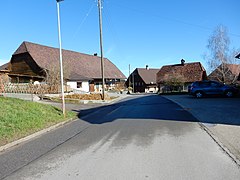
 Lurtigen with the school house (left) |
||
| map | ||
|
||


Lurtigen ( French : Lourtens ; Friborg Patois ) was a municipality in the lake district (French: District du Lac) of the canton of Friborg in Switzerland until December 31, 2015 . The partly still used French name of the municipality is Lourtens . On January 1, 2016 Lurtigen merged with Courlevon , Jeuss and Salvenach with the Murten community .
geography
Lurtigen lies at 567 m above sea level. M. , four kilometers east of the district capital Murten (linear distance ). The farming village extends on a hill between the Galmwald and the Murtenwald , on the Molasse Heights in the northern Freiburg Central Plateau .
The area of the 2.3 km² former municipal area comprises a section of the molasse heights between Lake Murten and the Saane Valley, which was shaped by the Ice Age Rhone glacier . The northern border runs in a valley low on the southern edge of the Murtenwald. From here, the municipality extends southward over the hill of Lurtigen (in the Buggli at 592 m above sea level, the highest elevation of Lurtigen) and the valley of the Lurtigenbach to the Galmwald ( 590 m above sea level ). In the west the area extends into the Salvenachfeld . A small exclave is located on the eastern edge of the Murtenwald. The community area is drained to the Biberen . In 1997, 4% of the municipal area was accounted for by settlements, 34% by forests and woodlands and 62% by agriculture.
Some individual farms belong to Lurtigen. Neighboring communities of Lurtigen were Murten , Ulmiz and Salvenach as well as the State Forest Galm area, which is not part of any community .
population
With 181 inhabitants (as of December 31, 2015) Lurtigen was one of the small communities in the canton of Friborg. 97.8% of the residents speak German, 1.1% speak French and 0.6% speak Portuguese (as of 2000). The population of Lurtigen was 200 in 1900. In the course of the 20th century, the population decreased to 160 people by 1980. Since then a slight population growth has been recorded again.
economy
Until the second half of the 20th century, Lurtigen was a village dominated by agriculture . Even today, arable farming , fruit growing and animal husbandry have an important place in the income structure of the population. Further jobs are available in local small businesses and in the service sector. In Lurtigen there is a cheese dairy and a heating system construction company. In the last few decades the village has also developed into a residential community. Many employed people are therefore commuters who mainly work in the Murten and Kerzers regions.
traffic
The former community is located away from the larger thoroughfares on a connecting road from Salvenach to Gempenach . The nearest connection to the A1 motorway (Bern-Lausanne) is around 6 km from the town center. Lurtigen is connected to the public transport network by the Transports publics Fribourgeois bus line , which runs from Murten to Gümmenen .
history
The first written mention of the place took place in 1397 under the name Lurtens ; In 1558 the name Lurtingen appeared . The place name is probably derived from the Gallo-Roman personal name Laurentius .
Lurtigen has been under the rule of Murten since the Middle Ages . In 1475, the village came under the joint administration of the estates of Bern and Freiburg as part of the bailiwick of Murten. After the collapse of the Ancien Régime (1798), Lurtigen came to the canton of Friborg. During the Helvetic Republic and the following period it belonged to the Murten district before it was incorporated into the lake district in 1848 with the new cantonal constitution.
Attractions
In the center there are some characteristic farmhouses from the 17th to 19th centuries. In Ofehüsli bread is still occasionally baked today. The schoolhouse dates from 1812 and has a valuable old clockwork.

Lurtigen, Pöllerefeld

Cheese factory building from 1914

In Lurtigen
In the village

Lurtigen seen from the State Forest Galm


Web links
- Website of the Lurtigen Village Association
- Hermann Schöpfer: Lurtigen. In: Historical Lexicon of Switzerland .
- Official website of the municipality of Lurtigen as of the end of 2015 in the Internet Archive
- Aerial views of the village
Individual evidence
Gurwolf | Courtepin | Cressier | Fräschels | Galmiz | Gempenach | Greng | Gurmels | Kerzers | Kleinbösingen | Meyriez | Misery Courtion | Mont-Vully | Muntelier | Murten | Ried near Kerzers | Ulmiz . Former municipalities: Agriswil | Altavilla | Barberêche | Bas-Vully | Cans | Castle | Chandossel | Cordast | Cormérod | Corsalettes | Courlevon | Cournillens | Courtaman | Courtion | Coussiberlé | Grossgurmels | Grossguschelmuth | Guschelmuth | Haut-Vully | Jeuss | Small gurmel | Kleinguschelmuth | Liebistorf | Lurtigen | Misery | Monterschu | Salvenach | Villarepos | Wallenbuch | Wallenried .