
Greng
| Greng | |
|---|---|
 |
|
| State : |
|
| Canton : |
|
| District : | lake |
| BFS no. : | 2261 |
| Postal code : | 3280 |
| Coordinates : | 573 758 / 195 614 |
| Height : | 439 m above sea level M. |
| Height range : | 429-465 m above sea level M. |
| Area : | 0.96 km² |
| Residents: | 174 (December 31, 2018) |
| Population density : | 181 inhabitants per km² |
| Website: | www.greng.ch |
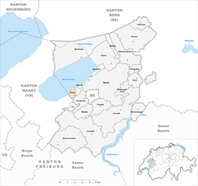
| Location of the municipality | |
  |
|
Greng is a municipality in the lake district (French: District du Lac ) in the canton of Friborg in Switzerland .
geography
Greng lies at 439 m above sea level. M. , 2.5 km southwest of the district capital Murten (linear distance). The village extends on the southern shore of Lake Murten near the mouth of the Dorfbach, on the edge of the adjacent heights, in the northern Freiburg Central Plateau .
The area of the municipality area of just 1.0 km² includes a section on the south bank of Lake Murten (around 1.5 km lakeshore length). The lakeshore has a reed belt, especially in the area of the peninsula near Fin de Dy . From the flat bank sections, the communal soil extends inland on both sides of the village stream coming from Courgevaux to the La Bourille forest ( 452 m above sea level ). At 464 m above sea level M. , the highest point in the municipality is reached on a meadow hill west of Greng-Dessus. In 1997, 15% of the municipal area was in settlements, 13% in forests and woodlands, 70% in agriculture and a little more than 2% was unproductive land.
Greng consists of the districts Greng-Dessous , 439 m above sea level. M. on the main road from Murten to Avenches, Greng-Dessus , 449 m above sea level. M. on the Dorfbach a little inland, and the western part of the hamlet of Blessoney ( 440 m above sea level ). Neighboring communities of Greng are Murten and Courgevaux in the canton of Friborg and Faoug in the canton of Vaud .
population
With 174 inhabitants (as of December 31, 2018), Greng is one of the small communities in the canton of Friborg. In 1428 there were five taxpayers recorded in Greng, which corresponds to a population of around 20 people. The population of Greng was 81 in 1850 and 70 in 1900. In the course of the 20th century, the population continued to decrease to 55 people until 1980. Since then, there has been a marked increase in population combined with a tripling of the number of inhabitants within 20 years.
languages
92.0% of the residents are German-speaking, 5.3% French-speaking and 0.7% speak Italian (as of 2000). This means that Greng is predominantly German-speaking today. The place name, derived from grange (barn), and the names Greng-Dessous and Greng-Dessus, which are still valid today, indicate an originally French-speaking village. The majority relationship between French and German probably reversed during the 17th or 18th centuries.
economy
Until the second half of the 20th century, Greng was a village dominated by agriculture . Even today, arable farming , fruit growing , dairy farming and cattle breeding play an important role in the income structure of the population. Further jobs are available in local small businesses and in the service sector. In the last few decades the village has also developed into a residential community. Many employed people are therefore commuters who mainly work in the Murten, Freiburg and Bern regions.
traffic
The community has good transport links. It is located on main road 1 from Bern via Payerne to Lausanne . The nearest connection to the A1 motorway (Bern-Lausanne), which opened in 1997, is around 6 km from the town center. Since August 25, 1876, the municipality has been crossed by the railway line from Murten to Payerne, but there is no stop in Greng, so there is no connection to the public transport network.
history
Traces of pile dwellings from the Neolithic were found on the shores of Lake Murten . The place was first mentioned in a document in 1314 under the name Gruein ; In 1349 the names Gruent and Grangiis (derived from the Latin grangia (barn)) appeared.
The Bishop of Lausanne leased several mills in Greng in the 12th and 13th centuries. Later various trades for cloth processing emerged from this, including an indienne factory that operated from 1775 to 1784 . The cloth industry was given up in the 19th century.
Since the Middle Ages Greng has been under the rule of Murten. In 1475, the village came under the joint administration of the estates of Bern and Freiburg as part of the bailiwick of Murten. After the collapse of the Ancien Régime (1798), Greng came to the canton of Friborg. During the Helvetic Republic and the following period it belonged to the Murten district before it was incorporated into the lake district in 1848 with the new cantonal constitution. From 1848 to 1982 Greng owned a joint municipal administration with the neighboring Meyriez , but the coffers were kept separate.
Attractions
The Greng Castle in Untergreng (formerly also called Grein ), which was built in 1785–87 as the owner's residence, is striking. Until 1803 it served variously as a meeting place for well-known personalities, including Madame de Staël and Benjamin Constant . The castle was restored from 1987 and the castle park was built over with assembled villas. Greng does not have its own church, it has always belonged to the parish of Meyriez.
Web links
- Official website of the municipality of Greng
- Ursula Birchler: Greng. In: Historical Lexicon of Switzerland .
- Aerial views of the village
Individual evidence
- ↑ Permanent and non-permanent resident population by year, canton, district, municipality, population type and gender (permanent resident population). In: bfs. admin.ch . Federal Statistical Office (FSO), August 31, 2019, accessed on December 22, 2019 .
Gurwolf | Courtepin | Cressier | Fräschels | Galmiz | Gempenach | Greng | Gurmels | Kerzers | Kleinbösingen | Meyriez | Misery Courtion | Mont-Vully | Muntelier | Murten | Ried near Kerzers | Ulmiz . Former municipalities: Agriswil | Altavilla | Barberêche | Bas-Vully | Cans | Castle | Chandossel | Cordast | Cormérod | Corsalettes | Courlevon | Cournillens | Courtaman | Courtion | Coussiberlé | Grossgurmels | Grossguschelmuth | Guschelmuth | Haut-Vully | Jeuss | Small gurmel | Kleinguschelmuth | Liebistorf | Lurtigen | Misery | Monterschu | Salvenach | Villarepos | Wallenbuch | Wallenried .