
Brünisried
| Brünisried | |
|---|---|
 |
|
| State : |
|
| Canton : |
|
| District : | Scythe |
| BFS no. : | 2292 |
| Postal code : | 1719 |
| Coordinates : | 587753 / 178616 |
| Height : | 875 m above sea level M. |
| Height range : | 817-1038 m above sea level M. |
| Area : | 3.25 km² |
| Residents: | 645 (December 31, 2018) |
| Population density : | 198 inhabitants per km² |
| Website: | www.bruenisried.ch |
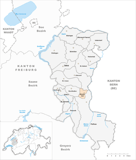
| Location of the municipality | |
  |
|
Brünisried is a municipality in the Sense district of the canton of Friborg in Switzerland . It is located in the Senseoberland .
geography
Brünisried is 875 m above sea level. M. , 11 km east-southeast of the canton capital Friborg (linear distance). The farming village extends on a high plateau west of the Sense , at the foot of the Oberholz, in the pre-Alpine hill country of the eastern Freiburg Central Plateau .
The area of the 3.2 km² municipal area comprises a section of the hill country at the foot of the Freiburg Pre-Alps . The area is bounded in the west by the forest height of the upper wood , on which with 1035 m above sea level. M. the highest point of Brünisried is reached. At 870 m above sea level M. at the eastern foot of this height is the Brünisried plateau, which is drained from the Grabenbach to the Sense. To the north, the municipality extends into the catchment area of the Galtera . In 1997, 7% of the municipal area was accounted for by settlements, 20% by forests and woodlands and 73% by agriculture.
Brünisried includes the hamlets Berg ( 933 m above sea level ) on a wide saddle east of the Oberholz, Menzisberg ( 930 m above sea level ) on a ledge on the eastern slope of the Oberholz and Holzgassa ( 850 m above sea level ) above the Galteratals as well as numerous individual farms. The neighboring communities of Brünisried are St. Ursen , Alterswil , Plaffeien and Rechthalten .
population
With 645 inhabitants (as of December 31, 2018) Brünisried is one of the smaller communities in the canton of Friborg. 98.4% of the residents are German-speaking, 1.1% French-speaking and 0.5% speak Albanian (as of 2000). The population of Brünisried was 277 in 1850 and 404 in 1900. In the course of the 20th century the population fluctuated between 390 and 440 inhabitants. Only since 1990 (457 inhabitants) has there been significant population growth.
economy
Until the second half of the 20th century, Brünisried was predominantly an agricultural village. Even today, dairy farming and cattle breeding and, to a lesser extent, arable farming play an important role in the income structure of the population. Other jobs are available in local small businesses and in the service sector, including a carpenter's workshop. In the last few decades the village has also developed into a residential community. Many workers are therefore commuters who mainly work in the Freiburg region.
traffic
The community is located off the major thoroughfares on a connecting road from Rechthalten to Zumholz . Brünisried is connected to the public transport network by the Transports publics fribourgeois bus route from Freiburg to Plaffeien .
history
The first written mention of the place took place in 1294 under the name Brunisriet . Since the Middle Ages Brünisried belonged to the rule Plaffeien; ecclesiastically it was under the parish of Rechthalten. In 1445 the village came under the rule of Freiburg and was assigned to the old landscape (Burgpanner). After the collapse of the Ancien Régime (1798), Brünisried belonged to the Freiburg district during the Helvetic and the following period, from 1831 to the German district of Freiburg, before it was incorporated into the newly created Sense district in 1848 with the new cantonal constitution. It was not until 1831 that Brünisried became an independent political municipality.
societies
There is a music society, a mixed choir, a football club and other clubs in Brünisried.
Attractions

Brünisried had its own church since 1919, but it was replaced by today's village church in 1971. The Buechenchäppeli stands at the height of the Oberholz .
Web links
- Official website of the municipality of Brünisried
- Jean-François Steiert : Brünisried. In: Historical Lexicon of Switzerland .
Individual evidence
- ↑ Permanent and non-permanent resident population by year, canton, district, municipality, population type and gender (permanent resident population). In: bfs. admin.ch . Federal Statistical Office (FSO), August 31, 2019, accessed on December 22, 2019 .
Alterswil | Bösingen | Brünisried | Düdingen | Giffers | Heitenried | Plaffeien | Plasselb | Keep right | Schmitten | St. Antoni | St. New Years Eve | St. Ursen | Tafers | Tentlingen | Ueberstorf | Wünnewil-Flamatt
Former municipality: Neuhaus | Upper shot | Zumholz
Canton of Friborg | Districts of the canton of Friborg | Municipalities of the canton of Friborg