Gurnigel
| Gurnigel Pass | |||
|---|---|---|---|
|
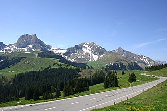
On the Gurnigelstrasse (Canton Bern) just before the Wasserscheidi; in the background on the left the Gantrisch (from the north) |
|||
| Compass direction | Northeast | southwest | |
| Pass height | 1608 m above sea level M. | ||
| Canton | Bern | ||
| Valley locations | Dürrbach | Sangernboden | |
| expansion | Pass road | ||
| Built | 1920s | ||
| Lock | no | ||
| profile | |||
| Ø pitch | 8% (786 m / 9.8 km) | 5.3% (632 m / 12 km) | |
| Max. Incline | 12.3% | 10% | |
| map | |||
|
|
|||
| Coordinates | 600699 / 175 639 | ||
The Gurnigel is a striking range of hills on the northern edge of the Freiburg Alps and a pass in the canton of Bern in Switzerland .
The hill
The Ober-Gurnigel ( 1548 m above sea level ), visible from afar, bears one of the oldest names in the region, which is derived from the Latin corniculum "croissant". As a lookout the Gurnigel Beginning in the 19th century when the spa guests of Gurnigelbades popular, and various artists recorded panoramas from there. The Ober-Gurnigel can only be reached on foot in around half an hour from the pass road at the Berghaus ( 1594 m ) via Gurnigelberghütte ( 1535 m ).
Further elevations of the range of hills are the Selibüel ( 1750 m ) and the Zigerhubel ( 1620 m ). Towards the northwest the range of hills descends towards the Schwarzwasser , towards the southeast towards the Gürbe . In the south, the Wasserscheidi ( 1584 m above sea level ) forms the transition to the Stockhorn chain . The Gurnigel is part of the Gantrisch region .
The Gurnigel consists of schisty flysch rock .
passport
The road leading over the range of hills begins in the hamlet of Dürrbach ( 828 m ) near Riggisberg . The Hotel Gurnigelbad ( 1155 m ), which was once widely known, is about halfway up . This part of the street is the oldest and was expanded in 1872 on the initiative of the hotel owner at the time, Johann Jakob Hauser.
In the 1920s, further expansion took place via Berghaus ( 1594 m ), Stierenhütte (pass height 1608 m ) and the so-called Wasserscheidi ( 1584 m ) to the Untere Gantrischhütte ( 1510 m ). A little below the same, the road branches towards Schwefelbergbad ( 1389 m ) and Sangernboden ( 977 m ) on the one hand and towards Schwarzenbühl ( 1491 m ) on the other. The route to Schwarzenbühl is a downright high-altitude road.
The Gurnigel is a year-round destination. A “Töfftreff” at the lower Gantrischhütte attracts motorcyclists, and every two years the Beo Bike Week , an international motorcycle meeting , is held at the Hotel Gurnigelbad .
In winter, a ski lift is in operation on the Wasserscheidi and at the Hotel Gurnigelbad. Cross-country trails are groomed throughout the region. Every year amateur astronomers hold one or more sky observation nights on the pass.
On the Wasserscheidi in the border area of the communities Riggisberg , Rüeggisberg ( exclave ) and Rüschegg , the Swiss Army maintains various tank firing ranges, which occasionally leads to conflicts with tourism.
Gurnigel hill climb
The Gurnigel mountain race takes place in September. The races were held on the gravel road from 1910 to 1931 and resumed in 1968 on the now paved track. The race track begins in Dürrbach ( Lage ) and ends at Gurnigelbad ( Lage ) . The start is in different categories for cars and motorcycles. The event attracts up to 20,000 spectators. The fastest time ever driven of 1'47.51 minutes results in an average speed of 125.669 km / h on the 3,734 m long, winding racetrack with an altitude difference of 314 m; the course record from 2006 was set by Eric Berguerand on a Lola T96, a group E2 formula-free racing car .
Le Gurnigel
Le Gurnigel is the French name for the area. Incidentally, a court settlement on the northern slope of Mont d'Amin in the canton of Neuchâtel also bears this name .
Web links
- Website of the Gurnigelbergrenn
- Map Rüti near Riggisberg, elevation profile of the pass road from Rüti
- Zollhaus map, elevation profile of the pass road from Zollhaus
Individual evidence
- ↑ Gurnigel mountain race , preview race 2012 ( memento of the original from November 29, 2014 in the Internet Archive ) Info: The archive link was inserted automatically and has not yet been checked. Please check the original and archive link according to the instructions and then remove this notice. , accessed May 28, 2012
- ↑ Automobil Revue of August 11, 2010, Heroes of the Post-War Era, Gurnigel Hill Climb ( Memento of the original of November 29, 2014 in the Internet Archive ) Info: The archive link was automatically inserted and not yet checked. Please check the original and archive link according to the instructions and then remove this notice. (PDF; 1.5 MB), accessed on May 28, 2012


