
St. Luzi dough
| St. Luzi dough | |||
|---|---|---|---|
 Pass height |
|||
| Compass direction | south | north | |
| Pass height | 713 m above sea level M. | ||
| Canton | Grisons | ||
| Valley locations | Maienfeld | Balzers , Liechtenstein | |
| expansion | Street | ||
| Lock | Max. Height 3.10 m | ||
| profile | |||
| Ø pitch | 6.7% (209 m / 3.1 km) | 4.2% (241 m / 5.7 km) | |
| Max. Incline | 11% | 11% | |
| Map (Graubünden) | |||
|
|||
| Coordinates | 758.72 thousand / 211781 | ||

The St. Luzisteig Rhaeto-Romanic Sogn Gliezi (pronounced Son Liezi) is a pass at an altitude of 713 m and connects the wine-growing town of Maienfeld with the northern valley town of Balzers in the Principality of Liechtenstein as main road 28 in the canton of Graubünden . The border between Liechtenstein and Switzerland runs south of Balzers, only one kilometer and just under 20 meters in altitude from the center of the village. Up to there the road changes twice from the municipality of Maienfeld to that of the municipality of Fläsch , whose own direct road connection to the pass was created by the army.
history
The north-south axis, which until the 19th century led exclusively over the St. Luzisteig, played a central role in the great debates in European history. This transition led to the Bündner Passes and was the gateway to Raetia for centuries. The road over "the Steig" is listed as a section of the Roman road Brigantium - Curia Raetorum ( Bregenz - Chur ) on the Peutinger plaque . The name of the pass goes back to Saint Lucius von Chur , who is said to have evangelized in this area and may have originally been buried here. The name Luzienstig is often used (especially in the dialect) .
St. Luzisteig fortress
At the culmination of the northern pass, protected by an old moat, lies the historic fortress St. Luzisteig with a gate building from 1702, which is still used today as a barracks for the Swiss Army . The fortress remained unchanged until 1855 and was rebuilt under the supervision of Gottlieb Heinrich Legler (1823–1897). A Malakoffturm (also known as the «Guschaturm» or «Hunger Tower») stands on the way to the Guscha , which is, however, a resized copy of a Malakow Tower . As a result of the Second World War , the Luzisteig blocking point (blocking point no. 1317) was expanded further. In 1937 tank barricades were built, bunkers and caverns in 1940/41 and the Römerstrasse artillery position in 1942.
There is a military museum on the site, in which, among other things, the role of the horse in the Swiss army is remembered. For 40 years the area served the "train recruit schools and troops". The pass road leads over the former drawbridge through the narrow gate and then through the middle of the fortress.
Fortifications
- Gatehouse 1703 ⊙
- Casematte D 1859 ⊙
- Casematte E 1859 ⊙
- Casematte F1 1859 ⊙
- Casematte F2 1859 ⊙
- Casematte F3 battery, later forge 1917 ⊙
- Stable accommodation 1880 ⊙
- Ammunition magazine / battery Herzog 1859 ⊙

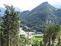
Church of St. Luzisteig with Guscha in the background

The situation between Landquart and Luzisteig in 1653, the Luziensteig at the bottom of the picture.
Fortress St. Luzisteig the way to the Guscha seen from

Luzisteig fortress


Pass height
The top of the pass is located in an exclave of the municipality of Maienfeld . The Steigkirche , first mentioned in 831, stands next to an inn . The current Gothic building with a late Gothic choir was the mother church of Maienfeld and Fläsch until the beginning of the 15th century. Inside the church is decorated with wall paintings from the 14th and 15th centuries, some of which can only be seen as fragments. Today the small church is used as a wedding church during the summer.
literature
- Inventory of historical traffic routes in Switzerland, status 1999: Route GR 1.5 “Deutsche Strasse” or “Reichsstrasse” over the St. Luzisteig
- Peter Baumgartner, Hans Stäbler: Fortified Graubünden. Wolves in sheep's clothing. Military History Foundation Graubünden, Chur 2006 ISBN 978-3-85637-321-4 . Extended edition Verlag Desertina, Chur 2016, ISBN 978-3-85637-485-3 .
Web links
- St.Luzisteig Military Museum
- Florian Hitz: Sankt Luzisteig. In: Historical Lexicon of the Principality of Liechtenstein .
- History of the Steigkirche
Individual evidence
- ^ Adolf Collenberg: Istorgia Grischuna, 2003, Lia Rumantscha, ISBN 3-03900-997-4 , page 91
- ↑ connecting road Fläsch-St.Luzisteig of the army on page 243 ( Memento of the original from May 31, 2013 in the Internet Archive ) Info: The archive link was inserted automatically and not yet checked. Please check the original and archive link according to the instructions and then remove this notice. (PDF; 340 kB)
- ↑ The name Luziensteig in the field names directory ( page no longer available , search in web archives ) Info: The link was automatically marked as defective. Please check the link according to the instructions and then remove this notice.
- ↑ Oberland Fortress: Luzisteig blocking point ( memento of the original dated August 19, 2016 in the Internet Archive ) Info: The archive link was inserted automatically and has not yet been checked. Please check the original and archive link according to the instructions and then remove this notice.
- ↑ Urs von Tobel, Observer: Train: “With the tanks, the planners are backing the wrong horse.” , Accessed on June 24, 2017
- ↑ Fortified Graubünden 1941
Ächerli • Agites • Aiguillon • Albis • Albula • Balmberg • Benkerjoch • Bernina • Böhler • Bözberg • Breitehöchi • Brünig • Buechenegg • Bürersteig • Chall • Challhöchi Pass • Champex • Chasseral • Chatzenstrick • Chilchzimmersattel • Croix • Croix • Croix de Coeur • Eichhöhe • Étroits • Etzelpass • Flüela • Forclaz • Furka • Ghöch • Givrine • glass • Glaubenberg • Glaubenbielen • Gottschalkenberg • Grimsel • Grosse Scheidegg • Gr.St.Bernhard • Gurnigel • Haggenegg • Hahnenmoos • Heitersberg • Hilferen • Hirzel • Hirzel Höhi • Hulftegg • Ibergeregg • Jaman • Jaun • Julier • Kerenzerberg • Klausen • Kunkels • Lein • Lenzerheide • Livigno • Lukmanier • Maloja • Marchairuz • Mollendruz • Mont Crosin • Monte Ceneri • Mont d'Orzeires • Montvoie • Morgins • Mosses • Mutschellen • Neggia • Nufenen • Oberalp • upper Hauenstein • Oberricken • oven • Orn • Passwang • Pierre Pertuis • Pillon • Planches • Pontins • Pragel • edge crossing • Rangiers • rates • Rengg • crocheted • Roches • 'groups • R üsler • Saanenmöser • Salhöhe • San Bernardino • Sanetsch • Santelhöchi • Sattel • Sattelegg • Schafmatt • Schallenberg • Schelten • Schönau • Schufelberger Egg • Schwägalp • Schwarzenbühl • Siblingerhöhe • Simplon • Splügen • St. Anton • St. Gotthard • St. Luzisteig • Staffelegg • Stoss • Susten • Tourne • Tronc • Umbrail • Unterer Hauenstein • Front Höhi • Vue des Alpes • Wasserfluh • Weissenstein • Wildhaus • Wissegg • Wolfgang