Balmberg
| Balmberg | |||
|---|---|---|---|
|
Balmberg |
|||
| Compass direction | North | south | |
| Pass height | 1078 m above sea level M. | ||
| Canton | Solothurn | ||
| Watershed | Dünnern → Aare → Rhine | Siggern → Aare → Rhine | |
| Valley locations | Welschenrohr | Gunsberg | |
| expansion | Street | ||
| Built | ? | ||
| profile | |||
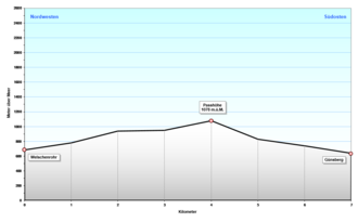
| Ø pitch | 14.6% (391 m / 4 km) | 9.8% (437 m / 3 km) | |
| Max. Incline | 25% | 11% | |
| map | |||
|
|
|||
| Coordinates | 607 635 / 235030 | ||
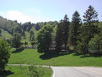
The Balmberg is a Swiss pass in the canton of Solothurn , which connects Welschenrohr and Günsberg . The south side of the Balmberg is a well-developed post bus route that is served from Solothurn. It is always well maintained, even in winter.
Pass road
The Balmbergstrasse North from Welschenrohr is at around 25% one of the steepest pass roads in Switzerland, if not the steepest in the country. There is therefore a warning sign at the lower end and the road is closed in winter. The road is also quite narrow, so that cars sometimes have to back up to let oncoming traffic pass. Despite the warning sign, this road is not completely free of motor vehicles, as it is the fastest connection to the Lebern SO district for the valley residents. It is also used by motorcyclists, especially on weekends.
The Balmberg has already been a stage location of the Tour de Suisse several times . In 1969 , 1972 , 1978 , 1981 , 1985 , 1990 and 1993 there was a mountain time trial over 12 kilometers from Solothurn to the Balmberg. In addition, the Balmberg is the region's ski area.
Origin of name
The name refers to the municipality of Balm near Günsberg on the south side and refers to prehistoric settlements on rocky overhangs, see Balm (toponym) .
Web links
- Balmberg ski area
- Max Banholzer: Balmberg. In: Historical Lexicon of Switzerland .


