Hulftegg
| Hulftegg | |||
|---|---|---|---|
|
Hulftegg |
|||
| Compass direction | southwest | Northeast | |
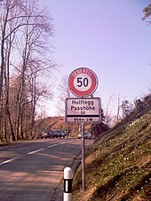
| Pass height | 954 m above sea level M. | ||
| Canton | Zurich | St. Gallen | |
| Watershed | Fuchslochbach → Töss | ||
| Valley locations | web | Mühlrüti | |
| expansion | Pass road | ||
| Built | 1867 | ||
| profile | |||
| Ø pitch | 5.6% (256 m / 4.6 km) | 6.5% (196 m / 3 km) | |
| Max. Incline | 10% | 10% | |
| Map (Canton of St. Gallen) | |||
|
|
|||
| Coordinates | 715 426 / 246832 | ||
The Hulftegg is a Swiss pass crossing in the foothills of the Alps at 954 m above sea level. M. between Mühlrüti (community Mosnang ) and Steg (community Fischenthal ).
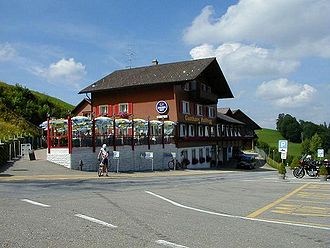
The pass road has been connecting Toggenburg in the canton of St. Gallen with the Töss Valley in the canton of Zurich since 1867 and has a maximum gradient of 10%. The pass forms the watershed between the river systems of the Töss and the Thur . The excursion restaurant of the same name, popular with cyclists and motorcyclists, is located at the top of the pass, which is entirely in the canton of St. Gallen.
The Hulftegg can be reached daily by bus from the Bütschwil (SG) train station.
history
The first written mention of the Hulftegg dates from 1656 as Hulfteren. In the 18th and 19th centuries, the pass was of some importance for the cattle trade and cotton transport. Before the construction of the pass road, the transition between Hulftegg (today Unter-Hulftegg) and Steg was about 200 meters further south below today's Chrüzegg farm. At that time, the crossing was around 30 meters higher, but the distance was shorter.
The seven kilometer long and five meter wide pass road was inaugurated 37 years after its planning after three years of construction in 1867. In the 19th century the Kurhaus Sennhof was built on the new pass road, where the excursion restaurant is located today.
Hiking opportunities
The Hulftegg is the starting point for the approx. 20-minute joke walking tour as well as for various hikes on the hills of the Zurich Oberland such as Hörnli or Schnebelhorn as well as in the Tössquell area.
The Toggenburger Höhenweg , which leads from Wildhaus to Wil SG , and the Höhenweg Züri Oberland from Winterthur to Rapperswil lead over the Hulftegg.
The Way of St. James from Konstanz to Einsiedeln ( called Swabian Way ) also passes nearby. Stations on the way were Fischingen Abbey and, after the ascent, the pilgrim inn in Allenwind and the one in Steg. If the pilgrim stayed on the path past the Grosse Hörnli past the Chlihörnli to the east and took the path that was better in the 19th century on the broad ridge of the Regelstein, he inevitably came to the so-called Chrüzegg, where a moderately steep footpath descends into the Töss Valley led.
Web links
- Website excursion destination Hulfteggpass
- Hans Büchler: Hulftegg. In: Historical Lexicon of Switzerland .


