
Glass pass
| Glass pass | |||
|---|---|---|---|
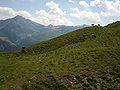
 The glass pass with a view to the west |
|||
| Compass direction | West side | East Side | |
| Pass height | 1846 m above sea level M. | ||
| Canton | Graubünden , Switzerland | ||
| Watershed | Carnusabach ( Rabiusa / Vorderrhein / Rhine ) | Black Nolla ( Nolla / Hinterrhein / Rhine ) | |
| Valley locations | Safien Square | Cazis | |
| expansion | Mule track | Pass road | |
| Mountains | Adula Alps | ||
| profile | |||
| Denzel scale | SG 3 | ||
| Ø pitch | 13.1% (550 m / 4.21 km) | 7.9% (1159 m / 14.7 km) | |
| Max. Incline | 15% | ||
| Map (Graubünden) | |||
|
|||
| Coordinates | 746 093 / 171 342 | ||

The Glaspass ( Rhaeto-Romanic claus " enclosure ", Latin clausum 'included' ), Rhaeto-Romanic also Tavellas , is an Alpine pass in the canton of Graubünden in Switzerland .
With a peak height of 1846 m above sea level. M. it connects Cazis and Thusis in Domleschg over Heinzenberg with Safien-Platz in Safiental . The summit of the pass, the eastern ascent and the Glas plateau lie within the municipality of Tschappina . The western section, called "Stäga" (stairs) in Walser, up to the ledge below it and the southern opposite slope of the Carnusabach (Verdusalp) are part of the Safiental community. The Glaspass is only accessible by car on the east side (to Innerglas 1.5 km west of the top of the pass).
photos

View from the northeast of the Glaspass
Middle Safiental, view of the Glaspass and Piz Beverin

Joshua Zinsli, the last mule trains on mule track over the Glaspass


Web links
Individual evidence
- ↑ Andrea Schorta: How the mountain got its name . Small Rhaetian name book with two and a half thousand geographical names of Graubünden. Terra Grischuna Verlag, Chur and Bottmingen / Basel 1988, ISBN 3-7298-1047-2 , p. 92 .
Albrun | Antrona | Augstbord | Balme | Barna | Bocchetta di Val Maggia | Boeuf | Bunder bark | Carmenna | Carnusa | Casanna | Chaschauna | Chésery | Cheville | Chräzeren | Chrüzli | Corno | Cristallina | Cou | Diesrut | Durand | Duranna | Encel | Euschels | Ferret Grand | Ferret Petit | Foo | Fórcola | Fuorcla Surlej | Fuorcla da Patnaul | Furcletta | Futschöl | Goat path | Gemmi | Giümela | Gredigs Fürggli | Greina | Semolina | Grünenberg | Güner Lückli | Gurin Furggu | Heidel | Heubützli | Hörnligrat | Illsee | Yoke | Jorat | Kinzig | Boxes | Kleine Scheidegg | Lona | Soldering | Lys | Maienfelder Furgga | Meidpass | Menouve | Monte Moro | Muretto | Naret | Niemet | Panixer | Pontimia | Rawil | Redorta | Riseten | Rotstein | Saas | Safierberg | Saflish | San Giacomo | San Jorio | Saddle | Scaletta | Schlappiner yoke | Schnidejoch | Schonegg | Schwialp | Segnes | Septimer | Sertig | Soladier | Soreda | Stallerberg | Strela | Surene | Susanfe | Tamier | Theodule | Tomül | Torrent | Trescolmen | Trütlisberg | Urdenfürggli | Valserberg | Zeblasjoch | Between mountains