Theodul Pass
| Theodul Pass | |||
|---|---|---|---|
|
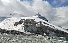
Theodul Pass in summer |
|||
| Compass direction | north | south | |
| Pass height | 3295 m above sea level M. | ||
| region | Canton of Valais | Aosta Valley region | |
| Watershed | Gornera | Marbles | |
| Valley locations | Zermatt | Breuil-Cervinia | |
| expansion | Alpine route (alpine transition) | Mule track | |
| Mountains | Valais Alps | ||
| profile | |||
| Denzel scale | SG 5 | ||
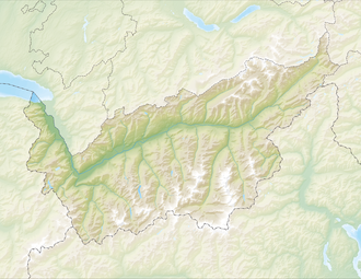
| Map (Valais) | |||
|
|
|||
| Coordinates , ( CH ) | 45 ° 56 '36 " N , 7 ° 42' 33" O ( 620 982 / 88018 ) | ||
The Theodulpass ( Walser German : Theoduljoch , Italian Colle del Teodulo , French Col du Saint-Théodule ), from the 16th to the end of the 18th century Augsttalpass (to Augst, the earlier German name of Aosta , Latin Augusta Praetoria ), later to the beginning of the 19th century simply Walliser Pass, then called Matterjoch , is a 3295 m above sea level. M. (as of 2009) high glaciated pass in the Valais Alps between the Matterhorn and the Breithorn .
geography
The pass, over which the border between Italy and Switzerland runs, connects Zermatt in the Mattertal with Breuil-Cervinia in the Valtournenche . The peculiarity of the Theodul Pass is its great height of 3295 m above sea level. M. (2009): No other alpine pass of comparable importance is higher than 2900 m above sea level. M. The Theodul Pass has always been an important transition in the Valais Alps . A stone ax found in 1895 comes from Brittany and is dated to the Neolithic period (4000 to 3500 BC). It suggests that the pass was already used at that time (but only in summer). A Roman coin treasure from the 1st to 4th centuries AD was also found near the top of the pass. This can be viewed today in the Alpine Museum in Zermatt.
The pass can be used all year round on the slopes on both sides. On the north side of the pass, the ski slopes lead over the here almost flat Upper Theodul Glacier . The Italian west side of the pass is ice-free. The Italian Theodulhütte is located directly above the pass .
history
When the glaciers had retreated a long way during the warm phase around 1000 to 1300, the Theodul Pass was also free of ice on the north side. The partially paved mule paths , the remains of which can still be seen today, date from the 13th century . The Walsers , who settled in the southern valleys of the Valais Alps in the first half of the 13th century ( Val d'Ayas and Lystal / Vallée du Lys ), also migrated over this pass. The Theodulpass is first mentioned by name in S. Münster 1543 as Augstalberg and Mons Sylvius or Siluius, d. H. Salasserberg translated back into German (such as at Safierberg with a mountain pass crossing into the Salasser valley), but then incorrectly interpreted as Silvius = German «wild». The latter name was only then transferred from the pass crossing to the Matterhorn next door. In 1688 a Savoy bastion was built on the pass. The glacier researcher D. Dollfuss set up a meteorological station in the former bastion that had been converted into a refuge in 1865 .
In honor of Bishop Theodul , who was active in morals , the pass was named after him from the end of the 17th century. In the Dufour map from 1862 the pass was still called “Matterjoch”.
Development
Today the area around the Theodulpass is accessible by cable cars from both the Swiss and the Italian side and is mainly used for ski tourism.
On the Italian side, the Bontadini lift is the highest point in the Alps that can theoretically be approached by motor vehicle , but access without a permit has been prohibited since 1985. The path that can be driven from the Italian side has a value of SG 5 on the Denzel Alpine Road scale .
literature
Individual evidence
- ^ Maps of Switzerland: Swisstopo time travel 1862
-
↑ Legal basis: Consiglio Regionale della Valle d'Aosta: Legge regional 22 April 1985,
n.17 - Testo vigente Comment: alpenrouten.de: Bontadini-Lift (mountain station) / Theodulhütte / Theodulpass , accessed on October 29, 2015


