
Fuorcla da Patnaul
| Fuorcla da Patnaul | |||
|---|---|---|---|
 Fuorcla da Patnaul from Pass Diesrut |
|||
| Compass direction | East Side | West side | |
| Pass height | 2773 m above sea level M. | ||
| Canton | Graubünden , Switzerland | ||
| Valley locations | Vals | ||
| expansion | Mule track | ||
| Mountains | Bündner Kalkalpen / Adula Alps | ||
| map | |||
|
|||
| Coordinates | 728 892 / 164474 | ||

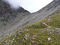
The Fuorcla da Patnaul ( 2773 m above sea level ) is an alpine pass in the Swiss canton of Graubünden . The pass connects the Valsertal with Vrin in Lugnez.
From the Vals side, the ascent to Leisalp ( 2051 m ) can be shortened with a hiking bus. From Vrin the ascent takes place first on the road to the alpine huts of Pardatsch ( 1586 m ). Immediately before you reach it, a mountain path branches off over Alp Patnaul ( 2227 m ) to the pass.

Signpost on the pass
View of the pass when climbing from the west
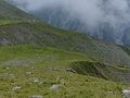
Alp Patnaul on the western side

Pardatsch, where the ascent to the pass begins


literature
- National maps LK: 257 Safiental 1: 50,000; 1234 Vals 1: 25: 000
Web links
Commons : Fuorcla da Patnaul - collection of images, videos and audio files