Adula Alps
| Adula Alps | |
|---|---|
|
The Adula Alps from Pizzo Terri to Adula seen from the Valle di Blenio . |
|
| Highest peak | Rheinwaldhorn ( 3402 m above sea level ) |
| location | Canton of Graubünden , Canton Ticino and Lombardy |
| part of | Lepontine Alps , Western Alps |
| Classification according to | SOIUSA |
| Coordinates , ( CH ) | 46 ° 30 ' N , 9 ° 2' O ( 722 935 / 150398 ) |
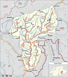
The Adula Alps , also known as the West Graubünden and Misox Alps , are part of the Lepontine Alps as a west- alpine mountain range . They form sub-section 10 III according to the international standardized orographic division of the Alps (SOIUSA) and section 10b according to the Partizione delle Alpi .
According to the alpine guides of the Swiss Alpine Club , they are not run as a separate group, but partly in Graubünden Alps 2: From Lukmanier to Domleschg , partly in Ticino Alps 3: From Piora to Pizzo di Claro and partly in Ticino Alps 4: Misox Alps , Described from the Zappothorn to the Passo S. Jorio . The highest mountain is the 3,402 m high Rheinwaldhorn .
They are located in Switzerland ( Canton Ticino , Canton Graubünden ) and, to a small extent, in Italy in the Lombard province of Sondrio .
In the Adula Alps, the establishment of the Adula National Park was planned, but the population voted against it.
Borders according to SOIUSA
They border:
- in the north to the Glarus Alps separated by the Vorderrhein
- in the northeast to the Plessur Alps bounded by the Hinterrhein
- in the east to the Platta group separated by the Hinterrhein and Splügenpass and the San Giacomo valley with the river Liro ; the San Giacomo valley lies in the Italian part of the Adula Alps
- in the southeast on the Bernina Alps bounded by the Chiavenna valley with the Mera river , again in the Italian part
- in the south to the Como Pre-Alps (part of the Lugano Pre-Alps ) separated by the Morobbia Valley , the San Jorio Pass and the San Jorio Valley
- in the south-west of the Ticino Alps, separated from the Riviera and Ticino valleys
- in the west to the Gotthard massif area of the Monte Leone-Sankt Gotthard Alps and bounded by the Medel Valley, the Lukmanier Pass , the St. Maria Valley and the Blenio Valley
Division according to SOIUSA
According to SOIUSA, the Adula Alps are divided into four supergroups and 10 mountain groups (the codes according to SOIUSA in brackets):
- in the northwest the chain Medelser-Terri ( A )
- Medel-Scopi group ( A.1 )
- Terri-Cavel group ( A.2 )
- in the southwest the Adula group ( B )
- Rheinwaldhorn group ( B.3 )
- Group Güferhorn - Fanellhorn ( B.4 )
- Group Zapporthorn - Groven ( B.5 )
- Fraciòn - Torrone Alto group ( B.6 )
- in the northeast the chain of Splügener Kalkberge ( C )
- Group Piz Tomül ( C.7 )
- Beverin Group ( C.8 )
- in the southeast the chain Tambo - Forcola ( D )
- Group Tambo - Pian Guarnei ( D.9 )
- Chain Piz della Forcola - Pizzo Paglia ( D.10 )
summit
- Rheinwaldhorn 3402 m
- Güferhorn 3379 m
- Pizzo Tambo 3279 m
- Grauhorn 3260 m
- Läntahorn 3237 m
- Piz Medel 3210 m
- Piz Cristallina 3128 m
- Scopí 3190 m
- Cima di Camadra 3172 m
- Cima Rossa 3161 m
- Zapporthorn 3152 m
- Piz Terri 3149 m
- Fanellhorn 3124 m
- Cime di Val Loga 3004 m
- Piz Beverin 2997 m
- Torrone Alto 2948 m
- Einshorn 2944 m
- Pizzo Tamborello 2858 m
- Pizzo di Claro 2727 m
- Pizzo Paglia 2593 m
- Pizzo Cavregasco 2535 m
- Cima dello Stagn 2380 m
- Sosto 2221 m
Refuges
- Adulahütte of the SAC , 2012 m
- Capanna Adula of the UTOE , 2393 m
- Camona da Medel , 2524 m
- Capanna Quarnei , 2107 m
- Länta Hut , 2090 m
- Zapporthütte , 2276 m
literature
- Sergio Marazzi: Atlante Orografico delle Alpi. SOIUSA . Pavone Canavese (TO), Priuli & Verlucca editori, 2005. ISBN 978-88-8068-273-8 (Italian)
- Sergio Marazzi, La “Suddivisione orografica internazionale unificata del Sistema Alpino” (SOIUSA) - the complete article with detailed illustrations (pdf; 1.6 MB) (Italian)
Web links
Individual evidence
- ↑ Bündner Alpen 2 : From Lukmanier to Domleschg
- ↑ Ticino Alps 3 ( Memento of the original dated November 16, 2011 in the Internet Archive ) Info: The archive link has been inserted automatically and has not yet been checked. Please check the original and archive link according to the instructions and then remove this notice. : From the Piora to the Pizzo di Claro
- ↑ Ticino Alps 4: Misox Alps, From Zappothorn to Passo S. Jorio , ISBN 3-85902-196-6
- ^ Club Alpino Svizzero sezione Ticino: Capanne CAS Ticino ( Memento of the original from March 10, 2012 in the Internet Archive ) Info: The archive link was automatically inserted and not yet checked. Please check the original and archive link according to the instructions and then remove this notice.
- ^ L 'Unione Ticinese Operai Escursionisti (UTOE), sezione di Bellinzona: Capanna Adula


