Ticino Alps
| Ticino Alps | |
|---|---|
|
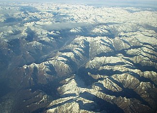
Ticino Alps from the southwest, in the middle the Val Verzasca , on the left the Valle Maggia , in the far background the Gotthard massif . |
|
| Highest peak | Basòdino ( 3272.4 m above sea level ) |
| location |
|
| part of | Western alps |
| Coordinates , ( CH ) | 46 ° 13 ' N , 8 ° 39' O ( 693 786 / 118655 ) |
| surface | 2,500 km² |
The Ticino Alps are a mountain range in the border area between the Italian province of Verbano-Cusio-Ossola and the Swiss canton of Ticino in the southeast of the Western Alps .
Location and area
Despite their size, the Ticino Alps are clearly delimited and can be described briefly (clockwise from the north) : Ticino , Lake Maggiore , Toce and Passo San Giacomo ; they cover an area of 2500 km². From Lake Maggiore in the south to 193 m above sea level. M. to their highest mountain, the 3272.4 m above sea level. M. high Basòdino there is a difference of 3079 m .
Groups and summits
The Ticino Alps are divided into the following nine subgroups:
- Basodino group
- Cristallina group
- Campo Tencia group with the Pizzo Campo Tencia
- Maggia group
- Verzasca group
- Onsernone group
- Pioda di Crana group
- Gridone group with the Gridone
- Monte Zeda group
For mountaineers there are nine huts run by alpine clubs in the area, such as B. the Cristallina hut of the SAC , plus a few others.
Valleys and places
In the interior of the mountain range there are Maggia , Verzasca and Centovalli with the towns of Bignasco , Maggia , Brione and Intragna , with Airolo , Biasca , Bellinzona , Locarno and Domodossola on the edge .
Web links
- Ticino Alps on your-berge.de (mountain & hiking portal )
supporting documents
- ↑ Maps of Switzerland (SwissTopo)
- ↑ Ernst Höhne: Knaurs Lexikon für Bergfreunde / The Alps between Matterhorn and Lake Constance . Droemer Knaur, Munich 1987, ISBN 3-426-26223-1 , p. 280 ff .

