
Gotthard massif
| Gotthard massif | ||
|---|---|---|
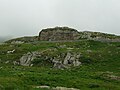
 Historically romanticized depiction of the Urnerloch (around 1790) |
||
| location | Graubünden / Ticino / Wallis / Uri , Switzerland | |
| part of | Central Switzerland or Lepontine Alps , Central or Western Alps . | |
| Classification according to | Servant (1891) Gotthard group ; SAC GO / D.3 Gotthard ; SOIUSA 10.IB | |
|
||
| Coordinates | 686 113 / 157047 | |
| rock | autochthonous crystalline basement (Para- and Orthogneiss), partly Triassic and Bündnerschist | |

The Gotthard massif or St. Gotthard massif ( Italian Massiccio del San Gottardo , Rhaeto-Romanic ) is a mountain range in the Swiss Alps in the Central Switzerland region . It is named after the Gotthard Pass , which in turn takes the name of St. Godehard von Hildesheim wears.
The Gotthard massif lies on the border of the cantons of Graubünden , Ticino , Valais and Uri .
On the concept of the Gotthard massif
Gotthard massif is an originally petrological - tectonic term ( massif in the sense of a compact rock mass), which was introduced in the early - geologically oriented - alpine research of the early 19th century.
Because geomorphology also uses the term massif for itself (in the sense of a sharply delineated, poorly structured mountain formation), the term has also found its way into other specialist areas. The area forms the heart of the Central Alps ; From here four of the great Alpine rivers ( Rhine , Reuss - Aare , Rhone , Ticino ) strive in all directions and form orographically fundamental structures of the Alpine arc.
Even after the traditional Swiss custom of naming mountain groups in the Alps according to cantons, the mountain group in the quadrangle has a special position, so that the name has become common in national geography.
Delimitation and classification
Depending on the geographical concept, the borders and the classification of the Gotthard massif are viewed differently.

In all spatial models, the core area is relatively consistent, stretching a good 20 kilometers between the Furka Pass ( 2429 m above sea level ) in the west over the Gotthard Pass (Passo del San Gottardo 2106 m above sea level ) to the Oberalp Pass (Alpsu , 2044 m above sea level ) in the northeast, and culminates on the one hand in the Muttenhörner (Grosses 3099 m above sea level ) and on the other hand in Pizzo Centrale ( 2999 m above sea level ), named after its location .

In the west, orographically speaking, the border can be extended to the Nufenen Pass (Passo della Novena, 2478 m above sea level ), which makes Pizzo Rotondo ( 3192 m above sea level ) the highest point here. The massif in the sense of geology extends to Brig-Glis in Upper Valais, which is why the Monte Leone group (in the broader sense, Simplon group) also reaches the Simplon Pass 2009 m above sea level. M. with the Monte Leone ( 3552 m above sea level ) mentioned in this group, which then extends far into Italian as far as Domodossola. Modern concepts of the Alpine structure provide for an extended Monte Leone – Sankt Gotthard train (SOIUSA).

In the east, the Lukmanier Pass (Passo del Lucomagno, Pass dil Lucmagn, 1915 m above sea level ) offers itself as a boundary, then with Piz Gannaretsch ( 3040 m above sea level ) as the highest point of the eastern part. Geologically, the Gotthard massif also continues to run until Übersaxen, deep in the valley of the Vorderrhein . This is why the Greina Pass ( Passo della Greina , Pass Crap 2354 m above sea level ) is the border, and Piz Medel ( 3210 m above sea level ) is the highest elevation (Diener).
Geologically, the massif ends north in the Ursern (Reussquelltal) at the northern foot of the Gotthard Pass. Most descriptions use the orographically characteristic line Goms (Rhone / Rotten) - Ursern - Surselva (Vorderrhein), but some mountain divisions oriented towards valleys add the mountains to the north ( Dammagruppe ), which means the group in the Dammastock ( 3630 m above sea level). ), where the Rhone has its origin, finds its highest point.

The Val Bedretto (Ticinoquelltal) near Airolo is the clear southern border . Geologically, the southern border then runs over the Pioratal, which strikes east from the Ritomsee (which is roughly followed by the SAC ). Orographically, what remains here is the southerly, relatively little high ridge between Valle Leventina and Val di Blenio ( Pizzo del Sole 2773 m above sea level ), which is then often added to the Gotthard massif (Diener, SOIUSA).
The group also has a special position within the overall structure of the Alps, because this is where the main Alpine ridge - which has a relatively clear course in the Western and Eastern Alps - and the one in Switzerland separated by the Rhone-Rhine furrow between Martigny and Chur meet Side ridge, in which the 4000 m peaks of Central Switzerland can be found, and which is seen as such as the central ridge. The main European watershed runs over the Gotthard Pass. Many divisions of the Alps therefore already count this group on the southern side of the Alps or at least the inner (Italian-side) Alpine arc and place the Gotthard massif together with the Ticino Alps in the Lepontine Alps (Diener, SOIUSA), but others in the Central Swiss Alps (SAC), again others run them completely independently for the same reason (SAC Modern).
Overall, the following boundaries of more widespread systems can be found (valleys in italics, for the strictly orographic systems the high and low points of the boundary with height information):
| Gotthard area (according to SAC) | |
|---|---|
| Highest peak | Pizzo Rotondo ( 3192 m above sea level ) |
| part of | (partly: Central Swiss Alps ), Swiss Alps |
| Classification according to | SAC GO or D.3 |
| Coordinates | 646852 / 151920 |
| surface | 430 km² |
- The typical Swiss Alpine Club (SAC) division gives the Gotthard area (highest peak: Pizzo Rotondo 3192 m above sea level ) as a subgroup (D.3) of the Central Swiss Alps or completely independent (GO) in relatively narrow areas Limits:
- in the west / north-west: Ulrichen VS - Obergoms to Gletsch → to the East Bernese Alps (Grindelwald – Grimsel area, BE 5 / B.5)
- in the north: Gletsch - Furka - Ursern to Andermatt UR → to the Göscheneralp – Furkapass – Grimsel area (UR 2 / D.1.c)
- in the northeast: Andermatt - Oberalp - Surselva to Disentis / Mustér GR → to the Osturner Alps (Oberalpstock and Windgällen area, UR O / D.1.b)
- in the east: Disentis - Val Medel to Lukmanier → to the Lukmanier – Domleschg area (GR 2 / E.2)
- in the southeast: from Lukmanier westwards to Airolo TI → to the Piora – Pizzo di Claro area (TI 3 / F.3)
- in the south: Airolo - Val Bedretto to Bedretto → to the Cristallina – Sassariente area (TI 2 / F.2)
- in the southwest: from Bedretto the Val Bedretto to the Nufenen → to the Gridone – St. Gotthard Pass (F1 / TI 1)
- in the southwest / west: Nufenen - Ägenetal to Ulrichen → to the Simplon – Nufenenpass area (VS 6 / C.6)
| Gotthard Group (after Diener) | |
|---|---|
| Highest peak | Piz Medel ( 3210 m above sea level ) |
| part of | Lepontine Alps , Western Alps |
| Classification according to | Servant (1891) |
| Coordinates | 712781 / 164066 |
| surface | 880 km² |
- The structure according to Carl Diener (1891), which has long been widespread in non-Swiss German-speaking countries, established a Gotthard group (highest peak: Piz Medel , 3210 m above sea level ) as part of the Lepontine Alps in the inner Gneiss Alps range in relatively wide boundaries:
- in the west / north-west: Ulrichen ( 1346 m above sea level ) - Gletsch → to the Finsteraarhorn group of the Bernese Alps
- in the north: Gletsch - Furka ( 2429 m above sea level ) - Andermatt ( 1447 m above sea level ) → to the Damma group of the Bernese Alps
- in the northeast: Andermatt - Oberalp ( 2044 m above sea level ) - Surselva to Sumvitg ( Surrein 897 m above sea level ) → to the Tödi group of the Glarus Alps
- in the east: Val Sumvitg - Passo della Greina ( 2354 m above sea level ) - Val Camadra to Ovilone - Val di Blenio to Biasca ( 303 m above sea level ) → to the Rheinwaldhorn group of the Adula Alps
- in the south: Biasca - Valle Leventina via Airolo - Val Bedretto to Paltano → to the Ticino Alps (part of the Lepontine Alps)
- in the south-west / west: Paltano - Nufenen ( 2478 m above sea level ) - Ulrichen → to the Simplon group of the Lepontine Alps
- The concepts of the neighboring groups mostly correspond roughly to those of the SAC.
| Rotondo-Centrale-Piz Bals group (Gotthard massif, according to SOIUSA) | |
|---|---|
| Highest peak | Pizzo Rotondo ( 3192 m above sea level ) |
| part of | Monte Leone-Sankt Gotthard-Alpen , Lepontine Alps , Western Alps |
| Classification according to | SOIUSA 10.IB |
| Coordinates | 646852 / 151920 |
| surface | 680 km² |
- According to the modern systematic SOIUSA categorization, the Gotthard massif , also known as the Rotondo-Centrale-Piz-Bals chain (to clarify the more precise concept), forms the supergroup (supergroup) B (full name 10th IB) in the Monte-Leone –Sankt-Gotthard-Alpen (10.I) as a section of the Lepontine Alps (10). The scope stands between the aforementioned (the neighboring groups are also super groups):
- in the west / north-west: Ulrichen ( 1346 m above sea level ) - Gletsch → to the chain Finsteraarhorn – Oberaarhorn – Galmihorn (12.II.A) of the Bernese Alps (in the narrower and broader sense)
- in the north: Gletsch - Furka ( 2429 m above sea level ) - Andermatt ( 1447 m above sea level ) → to the Dammastock – Sustenhorn chain (12.IA) of the Urner Alps (Bernese Alps in the w. S.)
- in the northeast: Andermatt - Oberalp ( 2044 m above sea level ) - Surselva to Disentis ( 1142 m above sea level ) → to the Oberalpstock – Clariden – Schärhorn chain (13.IA) of the Osturner Alps (Glarner Alps i. w. S.)
- in the east of Disentis - Val Medel to Lukmanier 1915 m above sea level. M. - Valle Santa Maria to Ovilone - Val di Blenio to Biasca ( 303 m above sea level ) → to the Medel – Terri chain (10.III.A) of the Adula Alps (part of the Lepontine Alps)
- in the southeast: Valle Leventina via Airolo to Osasco → to the Campo Tencia – Zucchero – Madone Grosso chain (10.II.D) of the Ticino and Verbano Alps
- in the south: Osasco - Valle Leventina / Val Bedretto to Paltano → to the Basodino – Cristallina – Biela chain (10.II.A) of the Ticino and Verbano Alps
- in the southwest / west: Paltano - Nufenen ( 2478 m above sea level ) - Ulrichen → to the Monte Leone – Blinnenhorn (10.II.A) chain of the Monte Leone – Sankt Gotthard Alps
- This structure corresponds to that according to Diener without the Piz Medel massif. The neighboring groups are natural mountain ranges and can also be found under other names.
The classification of the biogeographical regions of Switzerland of the SAEFL divides the Central Alps (4) but at the Furka Pass and from the southern flank of the Alps (6) on the main ridge, so that the northwestern parts of the Gotthard massif (with the valley of the Rhone Glacier ) according to the canton or valley borders the Western Central Alps (41 / WA1), the north- eastern parts of the Eastern Central Alps (42 / WA2) and the southern roofing of the Southern Alps (61 / SA1).
structure
The Gotthard massif is divided into two regions, one to the west and one to the east of the Gotthard Pass.
The SOIUSA divides the group into:
-
Group Gallina - Rotondo - Lucendro in the west (B.6)
- Group Pizzo Gallina ( 3061 m above sea level. M. ) (B.6.a) with the Mittagshorn ( 3015 m )
- Group Pizzo Rotondo ( 3192 m ) (B.6.b) with the Witenwasserenstock (m 3082)
- Group Pizzo Lucendro ( 2963 m ) (B.6.c)
-
Pizzo Centrale-Piz Blas chain in the east (B.7)
- Group Pizzo Centrale ( 2999 m ) (B.7.a)
- Group Piz Blas ( 3019 m ) (B.7.b)
-
Sole group in the southeast (B.8)
- Pizzo del Sole ( 2773 m ) (B.8.a)
- Pizzo Molare ( 2585 m ) (B.8.b) .
The demarcation of the three subgroups, the south-north line Tremola - Gotthard - Gotthardreuss respectively the eastward trending from Lake Ritóm Pioratal .
The third, south-eastern subgroup, which geologically is no longer part of the massif, belongs to the Ticino Alps according to the SAC system. Diener counts the mountains around Piz Medel to the Gotthard group, the SAC to the Bünder Alps, the SOIUSA to the Adula Alps .
The SAC is divided into Muttenhorns and Saashorns, Blashorn - Pizzo Gallina, Pizzo Nero - Poncione di Cassina Baggio, Chüebodenhorn - Witenwasserenstock, Pizzo Lucendro - Winterhorn , Pizzo Centrale - Gemsstock, Piz Alv - Badus, Piz Borel - Piz Cavradi, Piz Blas - Piz Paradis, Piz Rondadura - Piz Gannaretsch.
geology


The Gotthard massif is one of the four central massifs of the Swiss Alps , along with the Aarmassiv , the Aiguilles Rouges / Arpille massif and the Mont Blanc massif . It is geologically referred to as the Massif Central, because although it was compressed as a crystalline basement , it was not included in the construction of the Helvetic Nappe and is therefore considered to be autochthonous . The particularly intensive mountain formation in the Gotthard massif (high degree of metamorphosis, strong internal schistose) has led to almost vertical contacts (Gotthard cover with vertical structures) to the Swiss sediments on the edges of the massif.
At its northern edge of the massif bordering the Urserenzone the Mesozoic . This separates the Aar and Gotthard massifs as a steep, narrow furrow from Brig-Glis along the Rhone - Ursern - Vorderrheintales (Furkapass and Oberalp). In the Vorderrhein Valley, the Tavetsch intermediate massif (Bugnei hill near Sedrun ) pushes itself between the Aar massif and the Urser zone. The southern border of the Gotthard massif runs through Brig, Oberwallis , Nufenenpass , Val Bedretto , Airolo , Val Canada , Val Piora , Piz Scopí , Greina , Piz Tgietschen , Piz da Vrin to Obersaxen .
The massif can be divided on the east-west axis into the northern paragneiss zone , the central orthogneiss zone and the southern paragneiss zone. In between and mostly in the orthogneiss zone are the granite bodies of Rotondo, Fibbia , Gamsboden and Medelser / Cristallina. Either Triassic rocks or Bündner slate lie on the crystalline of the Gotthard massif on the entire southern edge .
The predominant type of rock in the Gotthard massif is gneiss .
Johann Wolfgang von Goethe was wrong about the structure of the soil in his writing Über den Granit : “Sitting on a high, bare summit and overlooking a wide area, I can say to myself: Here you rest directly on a base that extends to the deepest places on earth sufficient, no newer layer, no floating debris has settled between you and the solid ground of the primeval world. ”Due to a geological thrust , the gneiss in the Gotthard massif lies over younger layers, similar to the Tauern window .
In 1859 Albert Heim carried out the geological processing of sheet 14 Altdorf, Chur , scale 1: 100,000, of the Dufour map .
Karl von Fritsch carried out a comprehensive geological study of the massif around 1870, when he was still a lecturer at the Zurich Polytechnic, later the ETH Zurich . His geological map of the Gotthard massif from 1873 and his work The Gotthard area formed an essential basis for the project of the Gotthard railway tunnel , which was built from 1872 to 1882.
Strategic importance
In the Gotthard fortress area , the first fortresses to secure the north-south connection were built in the 1890s ( Fort Motto Bartola , Forte Airolo , Fort Hospiz ). In this room were some of the most important structures of the Swiss Redoubt , large fortress structures such as the fortress San Carlo , the fortress Foppa Grande and the fortress Sasso da Pigna , which were again greatly expanded or rebuilt in the Second World War , around the Swiss Alps as a retreat to defend the army against a possible invasion of the German and Italian troops.
Bunker of the Gotthard fortress Sasso da Pigna near Lago della Sella


Traffic axes
The Gotthard Pass (2108 m) and the Lukmanier Pass (1984 m) lead over the Gotthard massif in a north-south direction, and in an east-west direction the route over the Oberalp Pass (2044 m), through the Urserental and over the Furka Pass (2431 m).
The railway crest tunnel (1882), the Gotthard road tunnel (1980) and the Gotthard base tunnel (2016), the NEAT railway tunnel , were built through the Gotthard massif .
Watershed points

The main European watershed between the Mediterranean and the North Sea lies in the Gotthard massif . The watershed point of the North Sea, the western Mediterranean and the Adriatic is also located here . The two source rivers of the Rhine (to the North Sea and the Atlantic ), the Vorderrhein and the Hinterrhein , to the north, the Reuss , a tributary of the Aare that flows into the Rhine at Waldshut and Koblenz, arise in the east near the mountains of the Gotthard massif, and the Rhine to the west The Rhone , which begins at the Rhone Glacier and flows into the Mediterranean, and on the south side of the Ticino , a tributary of the Po that flows into the Adriatic , part of the Mediterranean.
tourism

The Vier-Quellen-Weg , opened in August 2012, is an 85 km long hiking trail in the Gotthard massif, which leads in five stages to the sources of the four rivers Rhine, Reuss, Ticino / Ticino and Rhône / Rotten.
Reliefs
Reliefs of the Swiss mountains have been created for schools, the military and other purposes since around the middle of the 19th century. In 2015, a Gotthard model was added to the world exhibition in Milan (Expo) with CNC technology milled from granite. The relief consists of five granite blocks lying next to each other and its size of 5 meters by 3.20 meters corresponds to the scale (1: 25,000) of the national maps of the country's topography. In order to create this mini version of the Gotthard, ... the help of swisstopo , the federal geographic information center, was needed.
Movie
- Documentary by Verena Schönauer: Myth Gotthard (Subtitle: Pass of the Pioneers ). Germany, SWR, 2018, 90 min. (With various researchers: Alexandra Binnenkade , Beat Frey, Hans Rudolf Fuhrer , Marcia Phillips, Johannes Rebsamen, Mauro Tonolla, Matthias Vollmer (geographer). Jean Odermatt's photo project is also presented.)
literature
- Gotthard special issue. In: NZZ Folio . 7/1995.
- Manfred Hunziker, Maurice Brandt, Giuseppe Brenna: Club guide Gotthard: From Furka to Lukmanier. Swiss Alpine Club, 1st edition, Bern 1995, ISBN 3-85902-149-4 .
Geology, by date:
- Albert Heim: The geology of the high Alps between Reuss and Rhine. Bern 1891.
- Helmut Stalder : Gotthard: The pass and its myth. Orell Füssli, 2016. Approx. 300 pages. ISBN 978-3-280-05617-2
- Robert U. Winterhalter: On the petrography and geology of the eastern Gotthard massif. Diss., ETH Zurich , Zurich 1930 (PDF; 6.1 MB).
Web links
- Gotthard massif on the ETHorama platform
- Vier-Quellen-Weg - official homepage
- Sasso San Gottardo - Experiences in the Gotthardfels , NZZ from August 24, 2012
Individual evidence
-
↑ a b c d e f Lit. Gotthard. SAC Club Leader, 1995;
Indication of the boundaries according to the overview SAC Club-Führer , stadler-markus.de - with map overview of the areas ;
Gotthard - Swiss Alpine Club with → map section (image view) , on mapfox.de. -
↑ a b c d e Sergio Marazzi: Atlante Orografico delle Alpi. SOIUSA . Pavone Canavese (TO), Priuli & Verlucca editori, 2005. ISBN 978-88-8068-273-8 (Italian);
Sergio Marazzi, La “Suddivisione orografica internazionale unificata del Sistema Alpino” (SOIUSA) - article with detailed illustrations (pdf, 1.6 MB; fioridimontagna.it, Italian). -
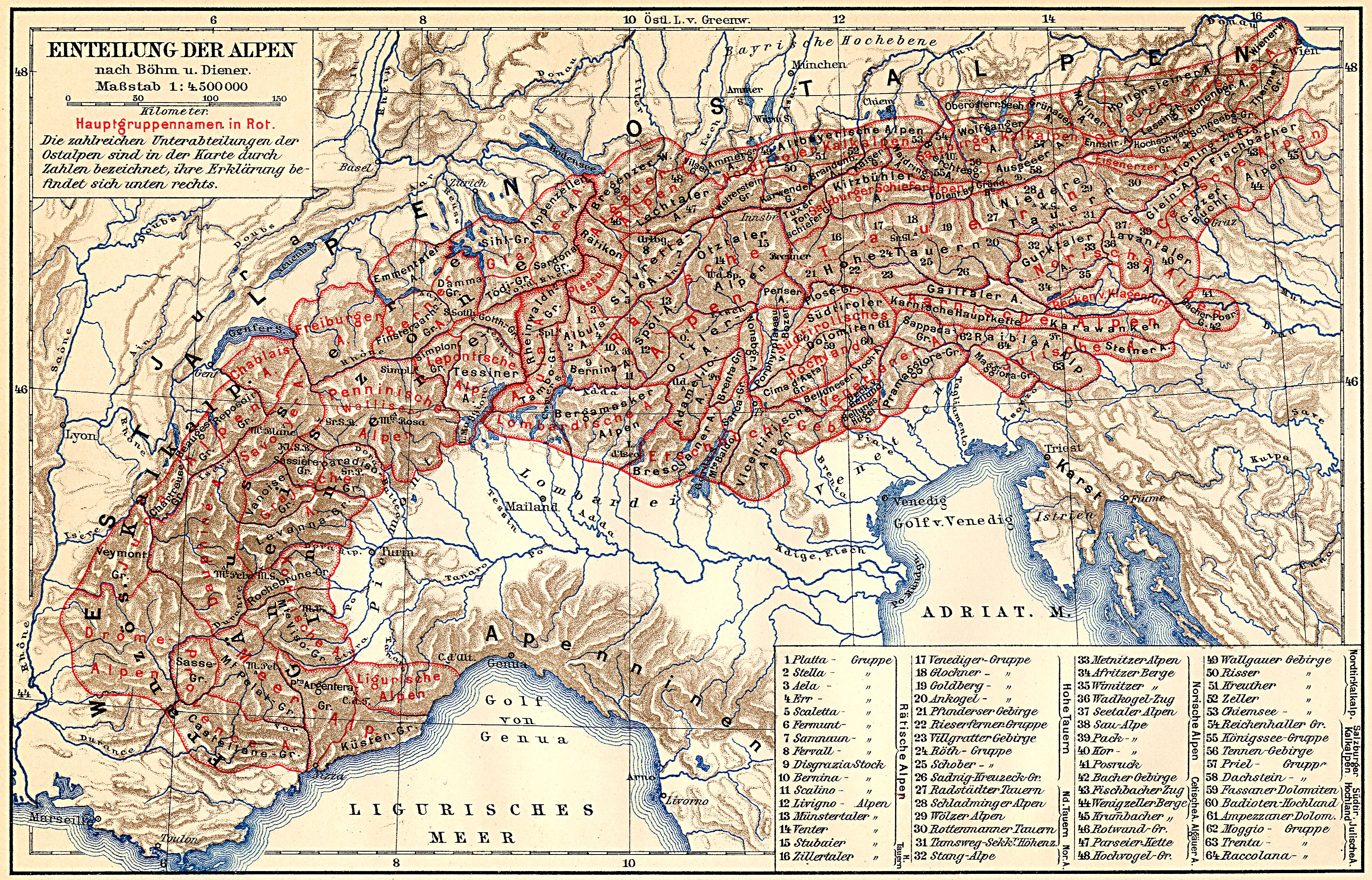
↑ a b c d Carl Diener : The mountain building of the western Alps . Tempsky / Freytag, Prague 1891. Used for example in: Alps . In: Meyers Großes Konversations-Lexikon . 6th edition. tape
1 . Leipzig 1905, 2nd geographic division of the Alps. [ Western Alps. ] 5) Lepontine A. , S. 362 - above, entire section 361-369 . ( zeno.org , classification according to Böhm and Diener, map 1: 4,500,000 ). - ↑ Since the SAC structure does not necessarily lead to valley lines, the exact limit is unclear here. Orographically, Lai da Sontga Maria - Val Cadlimo - Bochetta di Cadlimo (pass approx. 2530 m above sea level ) - Val Canaria could be seen. This boundary leaves the Lukmanier Pass itself on the left.
- ↑ a b Paltano is the location at the foot of the Passo San Giacomo , into the valley from All'Acqua
- ↑ a b An extended term for the established term of the Ticino Alps for the Italian area on Lake Maggiore (Verbano)
- ^ Toni P. Labhart: Geology of Switzerland. Ott Verlag, Thun 1992, ISBN 3-7225-6298-8 , p. OA
- ↑ Ruedi Weiss: Mountains and valleys milled out to the millimeter. In: Tessiner Zeitung of February 27, 2015.