
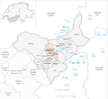
Goms district
| District Goms French District de Conches |
|
|---|---|
-coat_of_arms.svg) |
|
| Basic data | |
| Country: |
|
| Canton : |
|
| Main town : | Munster VS |
| FSO number : | 2304 |
| Area : | 589.20 km² |
| Height range : | 867-4273 m above sea level M. |
| Residents: | 4440 (December 31, 2018) |
| Population density : | 8 inhabitants per km² |
| Website: | www.goms.ch |
| map | |
 |
|
The district of Goms ( French District de Conches ) is located in the canton of Valais in Switzerland . The main town is Münster in the municipality of Goms .
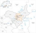
Geographical location

The uppermost valley section of the Upper Valais between the source of the Rhone and the valley step of Grengiols near Brig is called Goms . It is the easternmost part of the canton of Valais . In the east it is bounded by the Furka Pass , which lies between Galenstock and Pizzo Rotondo , and visually in the west by the Weisshorn . The uppermost section of the valley is still called Obergoms .
The Goms was carved out by the Ice Age Rhone Glacier . Then the valley floor was filled up by the Rotten , the young Rhone.
history
The Goms was inhabited as early as the Stone Age and was part of the Raetia province during Roman rule. The Alemanni invaded the Grimsel around the 9th century and overlaid the Franco-Provencal- speaking pre-population. In 1362 the Goms allied with the original cantons of the old Confederation .
The hotelier César Ritz was born in the Goms district in 1850.
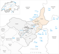
Communities
The district consists of the following municipalities:
As of January 1, 2017
| coat of arms | Name of the parish | Population (December 31, 2018) |
Area in km² |
Inhabitant per km² |
Average height of the settlement in m above sea level. M. |
|---|---|---|---|---|---|
|
|
Bellwald | 378 | 13.96 | 27 | 1560 |
|
|
Binn | 142 | 65.09 | 2 | 1400 |
|
|
Appoint | 492 | 35.37 | 14th | 1196 |
|
|
Fiesch | 921 | 11.04 | 83 | 1049 |
|
|
Fieschertal | 318 | 172.81 | 2 | 1108 |
|
|
Goms | 1216 | 129.59 | 9 | 1370 |
|
|
Lax | 309 | 5.41 | 57 | 1039 |
|
|
Obergoms | 664 | 155.93 | 4th | 1377 |
| Total (8) | 4440 | 589.20 | 8th | 1039-1560 | |
Changes in the community
Municipalities until 2000

Municipalities until 2004
Municipalities until 2008
Municipalities until 2016


- 1872: Niederernen and Ernen merge → Ernen
- 2001: Merger of Biel , Ritzingen and Selkingen → Grafschaft
- 2004: Merger of Ausserbinn , Ernen , Mühlebach and Steinhaus → Ernen
- 2004: Merger of Geschinen and Münster → Münster-Geschinen
- 2004: Merger of Gluringen and Reckingen → Reckingen-Gluringen
- 2009: Merger of Obergesteln , Oberwald and Ulrichen → Obergoms
- 2017: Fusion of Blitzingen , Niederwald , Grafschaft , Münster-Geschinen and Reckingen-Gluringen → Goms
The only remaining commune of the district of Goms and the canton of Valais was the commune of Reckingen-Gluringen / Grafschaft (BFS no .: 6391). Until December 31, 2003 it was officially called the Gluringen-Ritzingen Commune and carried the BFS no. 6072. The name change was necessary because in 2001 the former municipality of Ritzingen with Biel VS and Selkingen had merged to form the new municipality Grafschaft VS and in October 2004 the former municipality of Gluringen with Reckingen VS had merged to form the municipality of Reckingen-Gluringen . This last municipality of the canton disappeared with the merger in 2017 with the participating municipalities to form the municipality of Goms .
population
| Population development | |||||||
|---|---|---|---|---|---|---|---|
| year | 2010 | 2011 | 2012 | 2013 | 2014 | 2015 | 2016 |
| Residents | 4745 | 4716 | 4629 | 4569 | 4506 | 4452 | 4421 |
traffic
Roads into Goms lead from the north through the Lötschberg tunnel (car transport), from the east and south through the Furka base tunnel (car transport) with loading stations in Realp and Oberwald or in summer over the Furka pass , Grimsel pass and Nufenen pass or over the Simplon pass . From the west you can reach Goms via Sion along the Rhone Valley towards Brig . With the Matterhorn-Gotthard-Bahn , Goms can be reached by train from the west via Brig and east via the Furka tunnel. The Glacier Express travels through Goms on its route from St. Moritz to Zermatt .
Winter tourism
Due to its altitude and the alpine high valley, the Goms is a cross-country skiing area with guaranteed snow. Around 100 km of trails are available for cross-country skiers and skaters in winter. The trails connect twelve Goms villages with one another. There is also a night trail (4 km) between Obergesteln and Ulrichen and a dog trail (2 km) between Gluringen and Biel . The main trail is the flat Rotten trail (22 km) along the young Rhone. The Sonnenloipe (8 km) is located on the north side of the high valley.
In Obergoms there are also 85 km of winter hiking trails and 27 km of snowshoe trails. There is a Matterhorn Gotthard Railway station in every village .

Summer tourism

Around 700 km of marked hiking trails are available in summer. The Gommer Höhenweg , the Rottenweg in the valley floor and the hilly forest path on the south side of the valley connect the villages in Goms. A bicycle route runs along the course of the young Rhone from Oberwald to Brig .
The historic trains of the Furka mountain route steam train have been running completely between Oberwald and Realp UR in the canton of Uri again since 2011 .
Binntal
The Binntal , a remote side valley of the Goms, became famous for its mineral wealth . The whole valley is protected as a "landscape of national importance". The Albrun Pass has served as a transition to neighboring Italy since the Stone Age . The Walser took this route in the 13th century.
adjective
The adjective related to Goms is Gommer and not Gomser .
Web links
- Website Goms
- Arthur Fibicher: Goms. In: Historical Lexicon of Switzerland .
Individual evidence
- ↑ Permanent and non-permanent resident population by year, canton, district, municipality, population type and gender (permanent resident population). In: bfs. admin.ch . Federal Statistical Office (FSO), August 31, 2019, accessed on December 22, 2019 .
- ↑ Federal Statistical Office Generalized Limits 2020.