Binn
| Binn | |
|---|---|
| State : |
|
| Canton : |
|
| District : | Goms |
| BFS no. : | 6054 |
| Postal code : | 3996 |
| Coordinates : | 657 306 / 135303 |
| Height : | 1400 m above sea level M. |
| Area : | 65.0 km² |
| Residents: | 142 (December 31, 2018) |
| Population density : | 2 inhabitants per km² |
| Website: | www.binn.ch |
|
Binn |
|
| map | |
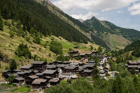
Binn ( Valais German bi [bɪ] ) is a Munizipalgemeinde and a civic community of the district Goms and a parish of the deanery Ernen in the Swiss canton of Valais . It is located in the Binn Valley , a side valley of the Rhone through which the Binna flows, which is why it is also called Binnatal .
places
The community emerged from the valley of Binn and today consists of the inhabited places Schmidighischere , Wileren , Giesse , Fäld and Ze Binne . The municipal administration is located in Schmidighischere, the most populous village.
The Heiligkreuz pilgrimage chapel stands on Binner Boden; The Maiensäss area of the same name, however, also extends to the municipal area of Grengiols .
history
Binn was first mentioned in 1246 as Buyn ; Another form of the name, Bondolum, is found in 1379. Both variants are common side by side up to the 17th century, e.g. 1589 Bin, 1609 Bindoli, 1654 Bundulo and 1667 Bin, which together with the tradition , which started late anyway, has made a reliable interpretation impossible .
In the area of today's municipality, Latène period , Celtic , Gallo-Roman and Roman grave and litter finds were made, which testifies to the importance of the Albrun Pass as a transition from Valais to northern Italy.
In the Middle Ages, Binn formed a quarter of the lower Zenden Goms ( Ernen ), but was at the same time an independent Meiertum until 1798 . The jurisdiction lay with the bishop of Sitten , who was only represented by a mistral, and from the 15th century by a meier elected by the people and appointed by the bishop. In 1297 it is mentioned as communitas ; since 1429 it has its own municipal statutes. Binn has been an independent parish since 1296/1298.
After the road was expanded in 1863/1864 and the Hotel Ofenhorn opened in 1883, the first tourists and mineralogists came to the valley. The sale of minerals was a lucrative additional income until World War I ; then the Lengebach site fell into disrepair until it was restored in 1958. The modern exploitation of iron ore , however, was given up in the 18th century.
In 1938 a winter-safe driveway was opened, in 1965 a road tunnel in the Twingi. In 1964 the valley was declared a nature and homeland reserve ("Binntal Landscape Park").
population
| Population development | ||||||
|---|---|---|---|---|---|---|
| year | 1850 | 1900 | 1920 | 1950 | 1990 | 2016 |
| Residents | 195 | 233 | 184 | 193 | 163 | 144 |
economy


The economy is shaped by tourism and agriculture . The community is part of the planned Binntal regional nature park. Binn is known for its minerals ; 19 minerals can only be found in the Binn valley. There are guided excursions into the mountains to find minerals. In this village there are two professional spotlights (crystal seekers) who can make a living from their profession.
Attractions
In addition to the old wooden houses in the settlements, there are the following striking structures:
- Parish Church of St. Michael, 1561–65, Wilern
- Stone arch bridge over the Binna, 1564, Schmidighischere
- Hotel Ofenhorn, 1881, Schmidighischere
Chapels
- Heiligkreuz pilgrimage chapel, 1660
- Chapel of the Annunciation, 1660, Giesse
- Chapel of St. Martin, 1660, Fäld
- Chapel of St. Antonius, 1690, Schmidighischere
- Chapel of St. Sebastian, 1725, Ze Binne
Partner communities
Binn maintains friendly relations with Arbon , Urtenen-Schönbühl and Baceno .
literature
- Alma Treyer: Binn. In: Historical Lexicon of Switzerland . 2004 .
- Walter Ruppen: The inner Binn valley, the Binn valley community . In: Society for Swiss Art History (Hrsg.): Kunstdenkmäler der Schweiz (= Vol. 67 ). Untergoms Vol. 2. Birkhäuser Verlag, Basel 1979, ISBN 3-7643-1080-4 , p. 148-220 .
Web links
Individual evidence
- ↑ Permanent and non-permanent resident population by year, canton, district, municipality, population type and gender (permanent resident population). In: bfs. admin.ch . Federal Statistical Office (FSO), August 31, 2019, accessed on December 22, 2019 .
- ^ Linguistic Atlas of German-speaking Switzerland , Volume V 1b.
- ↑ Lexicon of Swiss municipality names . Edited by the Center de Dialectologie at the University of Neuchâtel under the direction of Andres Kristol. Frauenfeld / Lausanne 2005, p. 157 f.
- ^ Previous building from the 13th century.
- ^ Hotel Ofenhorn Binn. Retrieved July 14, 2019 .
- ↑ Consecration of a chapel on site. The consecration of today's chapel on July 29, 1678.
- ↑ Blessing of a chapel at this location. On the gable, the year 1764, possibly the year of the ship.
- ↑ Blessing of today's chapel.


