
Stone house VS
| VS is the abbreviation for the canton of Valais in Switzerland and is used to avoid confusion with other entries in the name Steinhaus . |
| Stone house | ||
|---|---|---|
 |
||
| State : |
|
|
| Canton : |
|
|
| District : | Goms | |
| Municipal municipality : | Appoint | |
| Postal code : | 3995 | |
| former BFS no. : | 6070 | |
| Coordinates : | 656 821 / 141 412 | |
| Height : | 1269 m above sea level M. | |
| Area : | 5.7 km² | |
| Residents: | 34 (2004) | |
| Population density : | 6 inhabitants per km² | |
| Website: | www.ernen.ch | |
| map | ||
|
||


Steinhaus ( Valais German Steihüs [ˈʃteiˌhyːs (ː)] ) is a village in the Valais municipality of Ernen . Up until the spring of 2005, Steinhaus was an independent municipality .
Location, villagescape, traffic
Steinhaus is located together with the neighboring villages of Mühlebach and Ernen in the west and Niederwald in the east at the entrance to Goms .

The Steinhaus village was built on a sunny, south-facing high plateau near the Rufibach. The distance to the Rhone is approx. 250 meters, the one to the Rhone Glacier 21 km. The village lies on the former mule track , the «Via Regia». This extends through the whole of Upper Valais and was the main traffic connection through the Valais before the Furka road was built in 1860–1861. The road from Mühlebach leads through the unner village ("the lower village"). The houses at the entrance to the village face north. In the upper village there is the chapel and the former parish hall as well as numerous houses and barns .

At both ends of the village the upper summer houses , which were built between 1510 and 1630, are still very well preserved. Some of the houses have an almost completely intact floorboard (support beams of the ceiling, mostly the living room ceiling, often with rich inscriptions). The floor plan of the houses in Upper Valais is also interesting in this context. As a rule, all houses in the valley up to modern times were built according to this floor plan. In the center of the village you can find the houses built around 1710. In 1768 a large fire destroyed twelve buildings. The hamlets of Richelsmatt and Rottenbrücke near Steinhaus are no longer inhabited today, the former since 1830.
From Brig or Oberwald the route leads via Ernen and Mühlebach VS to Steinhaus. Steinhaus can be reached on this route by private car or public transport. Steinhaus can be reached on foot in 20 minutes from Niederwald .
Until 1960 there was only one telephone connection in the whole village, which all residents of the village used for incoming and outgoing calls. Contact with the outside world was marginal until the 1970s. Due to avalanches, the village was cut off from the outside world for weeks in winter until 1987. Thanks to the construction of a tunnel near Löüwibach («Lawinenbach») in 1987/1988, Steinhaus can now also be reached at any time in winter.
history

The village was first mentioned in 1245 as Domus lapidea ("stone house"), then in 1436 for the first time in German zem Steinhus .
In the Middle Ages , land in Goms was in all probability divided. One half was claimed by the Bishop of Sitten , the other half by several counts who came from northern Italy. Among these noble families were the lords of Biandrate, von Compeys, de Castello, de Platea, de Rodier and de Vineis. It is possible that one of these counts lived in Steinhaus, as the name of the place uff em Turre at the upper entrance to the village and the place name "Steinhaus" itself suggest. The awakening of the freedom rights of the Upper Valais strengthened the democratic idea and led to independence and self-administration in several struggles for freedom. The victories of the Valais in the battle of Ulrichen in 1211 against Duke Berchtold V von Zähringen and in 1419 against the Bernese testify to this . A large granite cross with the inscription «Den Helden von Ulrichen» commemorates this battle in a field in Ulrichen. In the fourteenth century they were very determined towards the episcopal sovereign: When Bishop Tavel von Sitten rode with his retinue into Goms in the autumn of 1361 to oblige the communities to more obedience, the Goms attacked the bishop near Steinhaus and held him eleven Trapped for weeks before he made great concessions to them. In 1417 the community issued its own statutes. From the Middle Ages to the end of the Ancien Régime, the Steinhaus community was part of the Ernen district in Untergoms (large parish of Ernen).
On September 16, 2004, the Great Council of the Canton of Valais decided to merge the municipal municipality of Steinhaus with the neighboring municipalities of Ernen , Mühlebach and Ausserbinn . On January 19, 2005, the Federal Supreme Court rejected the constitutional complaint of the Ausserbinn municipality against the Council of State and the Grand Council of the Canton of Valais on all points. Ausserbinn, Ernen, Mühlebach and Steinhaus were informed of this judgment on January 31, 2005, which finally made the merger of the four former municipalities legally binding. On 5th / 6th In March 2005 the residents of the former parishes decided that the new municipal parish should be called "Ernen".
Life and economy

In 1829 the community had 79 inhabitants, 1850: 97 inhabitants, 1900: 86 inhabitants, 1950: 87 inhabitants, 2000: 33 inhabitants and 2018: 19 inhabitants. Until the 20th century, most of the residents were farmers . Many of you emigrated to the USA because of the great poverty in the 1920s and 1930s . The poverty was sometimes so great that the cattle had to be fed with antler lichens ( Pseudevernia furfuracea ), Gragg in Valais , during the winter months due to the poor harvest in summer .
The economic conditions contributed to the fact that many residents of Steinhaus turned their backs on their village in later years and sought their earnings in prosperous areas. Today there is only one farm left. Today, many residents work down in the valley, in the Brig and Visp area , in the 2nd (goods processing and processing) or 3rd sector (services and administration).
tourism
After the Furkastrasse was opened in 1864, all traffic passed on the opposite side of the valley. Steinhaus suffered economic disadvantages as a result of this bypass, but was spared from traffic-related damage and renovations. The place is the starting point for hikes and bike tours into the Rappental, where up to 1000 sheep are summered in the summer. There is a ski area in the immediate vicinity of Steinhaus. The official cycle route “Rhone Route No. 1” leads from Oberwald via Steinhaus to Brig. It follows the former mule track , the “ Rottenweg ”. The Gommer Höhenweg , one of the more than 711 km long marked hiking trails of all levels of difficulty, connects the villages in Goms with each other.
Attractions

The center of the village is the village square with a fountain, which is framed by old houses. The village chapel was rebuilt around 1728/29. It is consecrated to the Holy Family . The altar was built by the sculptor Johann Joseph Bodmer from the neighboring community of Mühlebach. In the main niche, the Holy Family forms the Holy Trinity with God the Father under the Holy Spirit represented as a dove . In the side axis on the left St. Anthony of Padua , on the right St. Anne .
The former parish hall dates from 1794. At the entrance to the upper part of the village, the first house on the left after the junction from Niederwald is a Heidehüs . The year of construction should be between 1500 and 1630. The heather christening ("Heidenkreuz") on the gable front, which is characteristic of this type of building, with a typical beam and notched rosette is extremely well preserved. The oldest residential houses date from the late Middle Ages and are popularly called Heidehiischer ("Heidenhäuser").
Stone house personalities
The great mountain guide Johann Joseph Benet (1819–1864) was born in Steinhaus. He was also called "Bennen" by his friend John Tyndall and, because of his revolutionary mountaineering style, referred to as "Garibaldi the mountain guide". With John Tyndall and Ulrich Wenger, Johann Josef Benet (Bennen) managed the first ascent of the Weisshorn as a guide on August 19, 1861 . On July 18, 1861, he also succeeded in the first ascent of Mont Blanc (4810 m) together with Leslie Stephen, Francis Fox Tuckett , Melchior Anderegg and Peter Perren. On June 18, 1859, Benet (guide), Peter Bohren (guide), V. Tairraz (guide) and Francis Fox Tuckett climbed the Aletschhorn for the first time.
Pictures of stone house

Stone house in autumn 2018

Stone house in winter 2003

pure nature

When evening comes

chapel

tunnel

Rufibach

Heidehüs

Furkastrasse
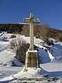
Ulricher cross

Parish hall

Stringer of the ceiling


Debris flows and "tidal waves"
Above Steinhaus there is a large demolition zone, which is responsible for the discharge of powerful debris flows . During a violent thunderstorm, the Rufibach carries large masses of rock, mud, gravel and trees towards the Rhone . This happens up to 10 times a year. The shaking of the ground is so great that a slight tremor is noticeable even in the houses of the village. This unique natural spectacle is experienced by the village population and guests from a safe distance with a mixture of worry, fear and fascination. Over the years, large debris walls have formed below the village (see picture), some of which are overgrown by a forest several decades old.
The rock material transported consists mainly of gneisses from the Gotthard massif of the Penninic . On the side walls of the Rufibach an accumulation of deposits from earlier Mur branches can be seen. The most impressive evidence of these debris flows can be found in front of the confluence with the Rhone in the form of a large mudflow.
July 7, 1998
The debris flow was so strong that the Rhone at Steinhaus was dammed into a 2.5 kilometer long lake over the weekend. In the aftermath of the debris flows, the water level of the Rhone rose to five meters.
17th August 2016
A large debris flow has spilled the bridge over the Rufibach in Steinhaus. The steel railings on both sides of the bridge were destroyed. The largest boulder that was transported with the bed load had a height of 2.70 m, a depth of 1.80 m, a width of 0.90 m and a weight of about 13 tons. After the debris flow, it took weeks for the rubble to be dredged out of the stream bed. A Cat chain excavator was used, the bucket of which can hold 2.00 m³ in one work step.

Bridge over the Rufibach after the debris flow on Aug. 17, 2016

Boulder after the debris flow on Aug. 17, 2016
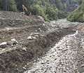
Crawler excavator, which piles up debris from the debris flow in steps (Sept. 2, 2016).
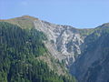
Demolition zone at the "stand"

Flood wave of the Rufibach

Flood wave of the Rufibach
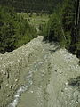
The Rufibach to Murgang


literature
- Bernard Truffer: stone house. In: Historical Lexicon of Switzerland .
- Walter Ruppen: Stone house . In: Society for Swiss Art History (Hrsg.): Kunstdenkmäler der Schweiz (= Vol. 67 ). Untergoms Vol. 2. Birkhäuser Verlag, Basel 1979, ISBN 3-7643-1080-4 , p. 110-119 .
- Marc Ozvatic: The Rufibach near Steinhaus (Valais, Switzerland). Investigations into the morphogenesis and mural activity of a side valley of the upper Goms. University publication for obtaining the degree of Diplom-Geographer, Institute for Geography, University of Stuttgart . Stuttgart June 14, 2006.
Web links
- Satellite image of Steinhaus on Google Maps
- Anton Carlen: Between two bridges. The parish of Ernen, its old houses and their former residents
Individual evidence
- ↑ a b c Lexicon of Swiss municipality names . Edited by the Center de Dialectologie at the University of Neuchâtel under the direction of Andres Kristol. Frauenfeld / Lausanne 2005, p. 854.
- ^ Jean Gremaud: Documents relatifs à l'histoire du Valais. Lausanne 1875–1898, Volume 1, p. 381. For the Latinization of place names in the Middle Ages, cf. also Hans-Robert Ammann: Latinized place names of Upper Valais from the parish registers. In: Blätter aus der Walliser Geschichte, 1997, vol. 30, p. 198.
- ^ Jean-François Bergier: The economic history of Switzerland. From the beginning to the present. Benziger, Zurich / Cologne 1983.
- ^ Bernard Truffer: Stone House. In: Historical Lexicon of Switzerland . 2017 .
Bellwald | Binn | Appoint | Fiesch | Fieschertal | Goms | Lax | Obergoms
Former parishes: Ausserbinn | Biel | Blitzingen | Geschinen | Gluringen | County | Mühlebach | Munster | Münster-Geschinen | Niederernen | Niederwald | Oberwald | Upper frames | Reckingen | Reckingen-Gluringen | Ritzingen | Selkingen | Stone house | Ulrichen
Canton of Valais | Districts of the canton of Valais | Municipalities of the canton of Valais