
Rhone

The Rhone [ ʁoːnə ] ( French - grammatically masculine : le Rhône [ləˈʁoːn], Occitan (more precisely: Provencal) lo (u) Rose [lu rɔze]) is a river of about 800 km in length, of which 264 km in Switzerland and 545 km in France .
It is the most water-rich river in France. The French departments Rhône and Bouches-du-Rhône are named after the river.
The Rhone rises in the Swiss canton of Valais at the foot of the Rhone Glacier and is also called "der Rotten" in German . After leaving the Alps, it flows through Lake Geneva . In southern France it flows into the Mediterranean with a delta .
Surname
Other forms of the name are Arpitan Rôno , Occitan Ròse . The original German name "der Rotten" is only officially in use in Upper Valais . The river is called Rottu in Valaisan German .
The Greeks called the river Ῥοδανός Rhodanos , and the Romans Rhodanus .
The river name is masculine in all neighboring languages .
River course
Alps
The Rhone rises from the Rhone Glacier in the Swiss canton of Valais . The meltwater is currently collecting in a lake at 2208 m above sea level at its edge. In the first 6.5 km it loses 840 meters in altitude, it passes the place Gletsch at 1757 m and then reaches the valley floor near Oberwald at 1368 m above sea level. From there it flows through the Valais Rhone Valley , in the upper section, the Goms, southwest and falls below 1000 meters on the southern edge of Fiesch . From Visp (643 m above sea level) to Martigny (372.2 m above sea level) it flows 72 km mainly westwards. The canton of Valais, which essentially consists of the Rhone Valley and its side valleys, lies between the main European watershed in the north and the main Alpine ridge in the south. This is where the highest peaks in the Swiss Alps rise . In Martigny the Rhone makes a striking 90 ° bend (the Rhone knee ) and then flows 37 km in a north-northwest direction, first through a narrow valley, then through the valley funnel around Monthey and Aigle VD . In the village of Le Bouveret , the Rhone flows into Lake Geneva , which it leaves again in Geneva . The river's water needs an average of 11.4 years to flow through the lake.
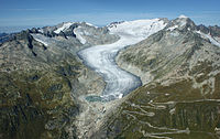
The Rhone Glacier , the origin of the Rhone (photo 2011)
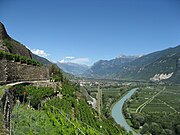
Rhone valley up above Sion

Lake Geneva in Geneva with Mont Blanc


law
After flowing out of Lake Geneva, the Rhone leaves Switzerland and heads west to the Jura . The breakthrough through this mountain range begins with the narrow Écluse between Collonges and Bellegarde-sur-Valserine and then extends for about 60 km in a north-south direction, as the river mainly flows through longitudinal valleys and switches from one valley to another when there are gaps or breakthroughs in the ridges . In the easternmost of these valleys lies the Lac du Bourget south of the Rhone , separated from the river by the silting zone of the Marais de Chautagne . In Saint-Genix-sur-Guiers the Rhone has traversed the Jura, then soaked but above the heights of the Jura foothills to the north, so it only after Lagnieu the broad tectonic reached the valley, which also includes the Belfort Gap and the Upper Rhine Graben belong. At the eastern edge of this valley, the Ain , also coming from the Jura, flows from the right, and the Saône at the western edge, also from the north . Between Pougny (Ain) and Les Baraques , the river forms the border between France and Switzerland over a length of about 9 kilometers.
First Jura breakthrough on the Rhone between Collonges and Bellegarde

Gorge de Balme , Jura breakthrough of the Rhone near Yenne

Rhone in Vienne , just under 30 km south of Lyon


Lower Rhone Valley
Lyon , the largest city on the Rhone, is located at the mouth of the Saône .
From Lyon , the Rhone flows south towards the Mediterranean. In the French Rhone Valley , which is broad here , the wine-growing regions of the Côtes du Rhône to Montélimar and the department of Bouches-du-Rhône to Avignon lie between the foothills of the Western Alps and the Cevennes . At Tarascon , the Rhone enters the Mediterranean plain, which, however , is bordered a few kilometers east of the river by the Alpilles .
Rhone Delta

At Arles , the Rhone divides into a delta of two arms, the Grand Rhône (the "Great Rhone") in the east and the Petit Rhône (the "Little Rhone"). Between the two arms stretches the Camargue , a wet plain known for its fauna but threatened by salinization, bordered to the south by lagoons, the largest of which is the Étang de Vaccarès . The tourist and pilgrimage site of Saintes-Maries-de-la-Mer is located at the mouth of the Little Rhone . East of the mouth of the Great Rhone at Port-Saint-Louis is a bay, the Golfe de Fos , lined with port and industrial facilities , named after the city of Fos-sur-Mer on its north bank. Already at Fos-sur Mer there are hills up to almost fifty meters above sea level, and beyond the Canal de Caronte , which may have been dug in ancient times , the mountainous coast of the Côte d'Azur begins .

Petit Rhône in Arles


Cities on the Rhone
A selection of larger or otherwise known cities on the Rhone (order downstream):
| Surname | Residents (municipality) | Inhabitants (metropolitan area) | Sea level | annotation |
|---|---|---|---|---|
| Brig-Glis | 13,088 | 691 m | Starting point of the Simplon Pass and the intersection of the Lötschberg axis with the Swiss Rhone Valley . | |
| Manners | 33,532 | 515 m | Capital of the canton of Valais | |
| Martigny | 17,651 | 471 m | Starting point of the Col de la Forclaz on the Arve with Chamonix at the western foot of the Montblanc and the Great Saint-Bernhard in the Aosta Valley | |
| Lausanne | 133,521 | 372 - 929 m | on the north shore of Lake Geneva, capital of the Vaud region | |
| Geneva | 201.164 | 369 - 458 m | known as the seat of many international organizations | |
| Seyssel | 2,276 + 965 | 250 - 937 m | Seyssel (Haute-Savoie) on the left and Seyssel (Ain) on the right bank of the Rhone | |
| Lyon | 500,715 | 2,237,676 | 162 - 305 m | largest city on the Rhone |
| Vienne | 29,325 | 111,606 | 140 - 404 m | |
| Valence | 71,767 | 175,636 | 106 - 191 m | |
| Montélimar | 36,643 | 74,692 | 56 - 213 m | "Capital of Nougat " |
| orange | 29,193 | 27,279 | 24 - 127 m | roman u. a. “ Stadtgründungsbogen ” and theater; historical references and a. Defeat of the Romans at Arausio in 105 BC Chr. And Wilhelm von Nassau-Orange in the Dutch struggle for independence . |
| Châteauneuf-du-Pape | 2,199 | 20 - 130 m | former papal summer residence; well-known wine-growing region | |
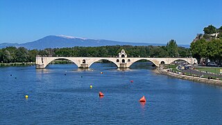
| Avignon | 90,305 | 518.981 | 10 - 122 m | 1309–1377 seat of the popes ; incomplete bridge Pont Saint-Bénézet |
| Beaucaire | 16,036 | 1 - 156 m | ||
| Tarascon | 13,941 | 2 - 200 m | Dragon story | |
| Arles | 52,566 | 55,876 | 0 - 57 m | roman u. a. Theater, forum and arena (amphitheater); a place of activity of Vincent van Gogh |
| Port-Saint-Louis | 8,565 | 0 - 3 m | The Grand Rhône flows into the sea |
Brig and the Bietschhorn

Geneva, at the outflow from Lake Geneva

Seyssel ( Haute-Savoie )

Today's Lyon emerged from the Roman settlement of Lugdunum

Lyon with the Saône (foreground) and Rhone (background) rivers
Ruins of the Pont Saint-Bénézet near Avignon

Roman arena in Arles
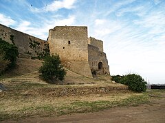
Fortress at Fos-sur-Mer


Rhone river system
The Rhone has numerous tributaries. Direct tributaries with a length of more than 100 kilometers in the order of their length:

The Saône, where it joins the Rhone in Lyon, has already covered a longer stretch than this. The stretch of the river from Saône and the lower Rhone is 860 km longer than the course of the Rhone itself with 812 km. The longest river route in the Rhone river system, from Rhone – Saône– Doubs - Cébriot , measures 1031 km.

This map in 20% projection - 749 × 1114 px
The Rhone, its main tributaries and their most important tributaries from 36 km in length:
Explanations for the following table:
- Upstream order
- If in a line the indication of the confluence side (“right” / “left”) has been moved under the name box of a line above, the body of water shown in the bottom line flows into the one shown in the above line.
- If an inflow of a next higher-ranking river is listed in the line under an inflow of a tributary of a tributary, the associated page number is accordingly further ahead under the beginning of the name box of the higher-ranking river.
- Arrows point downstream and mark the upper parts of a previously mentioned river course.
- If both bodies of water arriving at a confluence are officially classified as source rivers of the body of water below, their mouths are marked with “↑ left” and “↑ right”.
- Waters less than 36 km are included if they can be viewed as the hydrological upper or lower reaches of a longer river.
Source links:
- French water numbers → respective dataset of the database SANDRE
- Swiss water body numbers → suitable section of the interactive map VECTOR25 water network of the Federal Office of Topography (swisstopo) - clicking on the water body sections results in GEWISS numbers and (partial) lengths. The measuring function can be used to determine total lengths and obtain height information.
| Inflow in the direction of flow seen from |
Surname | Location of the mouth | Water number: SANDRE (FR) , GEWISS (CH) |
Length [km] |
Catchment area [km²] |
mean discharge [m³ / s] |
|||
|---|---|---|---|---|---|---|---|---|---|
| Rhone | Rhone Delta | V --- 0000 CH: 95 | 812 | 95,590 | 1,690 | ||||
| right |
Gardon or Gard including sections Gardon d'Anduze (16 km) u. Gardon de Mialet |
10 km above Beaucaire | V71-0400 | 127.3 | 1999 | 32.7 | |||
| Left | Gardon d'Alès | at Vézénobres | V7150500 | 60.6 | 444 | ||||
| right | Gardon de Saint-Jean | 10 km above. Anduze | V7130500 | 49.4 | 265 | ||||
| Left | Durance | South edge of Avignon | X --- 0000 | 323.5 | 14,342 | 180 | |||
| right |
Coulon ← Calavon with at the confluence. longer inflow: |
Cavaillon | X34-0400 | 88.2 | 1,028 | 1.17 | |||
| right | Riaille ← Ravin de Font Brune | 2.3 km above Valsaintes (4 km east of Simiane-la-Rotonde ) |
X3400500 | 20.7 | |||||
| Left | Verdon | 10 km above. Saint-Paul | X2-0200 | 165.7 | 2,294 | 26.8 | |||
| right | Colostre | 10 km above. Gréoux-les-Bains | X27-0400 | 36.2 | 215 | ||||
| right | Largue ← Crapon | 10 km above. Manosque | X27-0400 | 36.2 | 215 | ||||
| Left | Aces ← Aces de Clumanc | 10 km above. Manosque | X14-0400 | 75.3 | 500 | 5 | |||
| Left | Bléone | at Les Mées | X12-0400 | 67.5 | 906 | ||||
| right | Bès | 10 km above. Digne-les-Bains | X1220500 | 38.8 | 233 | ||||
| right | Jabron | 10 km below Sisteron | X1100500 | 36.5 | 205 | ||||
| right | Buëch | in Sisteron | X10-0400 | 85.2 | 1,478 | 23 | |||
| Left | Petit Buëch | 10 km above Serres | X1020500 | 44.9 | 389 | 20.2 | |||
| right | Sasse | 10 km above Sisteron | X07-0400 | 38.4 | 332 | ||||
| Left | Ubaye | 10 km above. Lac de Serre-Ponçon | X04-0400 | 82.7 | 1.011 | 20.5 | |||
| Left | Guil | 10 km above Mont-Dauphin | X02-0400 | 51.5 | 727 | 17th | |||
| Left | Ouvèze | 10 km above Avignon | V6-0200 | 93.3 | 2,200 | 25th | |||
| Left | Sorgue de Velleron with a longer tributary: | at Bédarrides | V6150500 | 30.4 | 1,083 | 18.1 | |||
| Left | Nesque | 10 km from its mouth | V61-0400 | 53.3 | 406 | ||||
| Left | Aigue / Aygues ← Eygues | SW of Orange | V53-0400 | 114.2 | 473 | 6.22 | |||
| right | Cèze | opposite orange | V54-0400 | 128.4 | 1,359 | 22nd | |||
| Left | Lez | at Mornas | V52-0400 | 73.5 | 445 | ||||
| right | Ardèche | 1 km above. Mont-Saint-Esprit | V50-0400 | 125.1 | 2,376 | 65 | |||
| right | Chassezac | 10 km below Ruoms | 5040500 | 84.6 | 560 | 15.3 | |||
| right | Altier | at Pied-de-Borne | V5040660 | 39.1 | 150 | 3.5 | |||
| right | Beaume (Ardèche) | at Ruoms | V5030500 | 43.9 | 244 | 7.6 | |||
| Left | Roubion | in Montélimar | V44-0400 | 66.6 | 612 | ||||
| Left | Drôme | down against La Voulte-sur-Rhône | V42-0400 | 110 (110.7) |
1,663 | ||||
| Left | Véore | 10 km upwards La Voulte-sur-Rhône | V40-0400 | 37.6 | 392 or 383 | 2 | |||
| right | Eyrieux | 1 km above. La Voulte-sur-Rhône | V41-0400 | 83.4 | 865 | 15.5 | |||
| Left | Isère | Valence | W --- 0000 | 286 | 11,890 | 330 | |||
| right | Herbasse | 10 km above its mouth | W35-0400 | 40 | 187 | 1.5 | |||
| Left | Drac | in Grenoble | W2-0200 | 130.2 | 3,626 | 99 | |||
| right | Romanche | at Vizille | W27-0400 | 78.3 | 1,222 | 38.4 | |||
| Left | Arc | 10 km south of Grésy-sur-Isère | W10-0400 | 127.5 | 1,985 | 31 | |||
| right | Arly | Albertville | W04-0400 | 34.5 | 648 | 25th | |||
| right | Doux | Tournon | V37-0400 | 70.1 | 631 | 7.5 | |||
| Left | Galaure | Saint-Vallier | V36-0400 | 56.2 | 232 | 2.2 | |||
| right | Cance | 10 km above. Saint-Vallier | V35-0400 | 41.3 | 380 | 4.2 | |||
| Left | Claires ← Collières with a longer influx: | Saint-Rambert-d'Albon | V3430560 | 21.7 | 631 | low | |||
| Left | Rival → Raille → L'Oron | 10 km from its mouth |
V34-0430 V34-0400 |
> 60 | |||||
| Left | Varèze | across from Chavanay | V3300500 | 39.2 | |||||
| right | greed | Givors | V31-0400 | 40.3 | 417 | 32 | |||
| right | Saone | Lyon (165 m above sea level) | U --- 0000 | 480 | 29,950 | 473 | |||
| right | Azergues | Anse | U46-0400 | 61.9 | 886 | 7.5 | |||
| right | Brévenne | Chazay-d'Azergues | U4635010 | 39 | 437 | 3.1 | |||
| right | Turdine | Lozanne | U4630660 | 28.7 | 161 | 1.5 | |||
| Left | Chalaronne | Thoissey | U4400500 | 52 | 175 | 1.0 | |||
| Left | Veyle | Mâcon | U42-0400 | 66.9 | 672 | 6.8 | |||
| Left | Renon | Vonnas | U4230500 | 40.8 | 131 | 0.8 | |||
| Left | Reyssouze | Pont-de-Vaux (Reyssouze) | U40-0400 | 75.1 | 495 | 1.4 | |||
| Left | Seille | 10 km below Tournus | U34-0400 | 100 | 2,620 | 30.8 | |||
| Left | Sane-Vive or Sane | 10 km below Cuisery | U3470500 | 46.8 | 295 | ||||
| Left | Sane-Morte | 10 km below Cuisery | U3470580 | 54.6 | 127 | ||||
| Left | Solnan | Louhans | U34-0430 | 61.6 | 680 | 13 | |||
| right | Vallière | Louhans | U3450500 | 50.8 | 250 | 5 | |||
| Left | Sevron | 10 km southwest. Front brew | U34-0430 | 54.6 | 195 | 3.0 | |||
| right | Burn | 10 km east of Saint-Germain-du-Bois | U3410500 | 53.8 | 445 | 5.1 | |||
| right | Great | 12 km below Chalon | U32-0400 | 95.6 | 1,000 | 10 | |||
| Left | Guye | 10 km west of Malay | U3220500 | 46.6 | 430 | 2.1 | |||
| right | Dheune | 10 km below. Verdun-sur-le-Doubs | U30-0400 | 76.5 | 1,059 | 6.79 | |||
| Left | Meucine | 10 km above . Palleau | U3030500 | 38.1 | |||||
| Left | Doubs | Verdun-sur-le-Doubs | U2-0200 , CH: 135 | 453 | 7,760 | 176 | |||
| Left | Guyotte | Navilly | U2740500 | 41.1 | 160 | 6.5 | |||
| Left | Orain | at Chaussin | U2710500 | 39 | 200 | 2.9 | |||
| Left | Loue | 12 km up. Dole | U26-0400 | 127.2 | 1,733 | 59.2 | |||
| right | Allan ← Allaine | near Montbéliard (165 m above sea level) | U23-0400 , CH: 93 | 65 | 1,120 | 22.8 | |||
| right |
Bourbeuse ↑ Saint-Nicolas |
10 km below Morvillars | U23-0420 | 39.8 | 708 | ||||
| Left | Cébriot | 1.8–1.9 km after the source of the Doubs | U2000500 | 8.5 | |||||
| right | Ouche | Saint-Jean-de-Losne | U13-0400 | 95.4 | 973 | 8.5 | |||
| right | Tille | 10 km above. Saint-Jean-de-Losne | U12-0400 | 82.7 | 1,100 | 11.1 | |||
| right | Ignon | Is-sur-Tille | U1210500 | 44.2 | 378 | 3.3 | |||
| Left | Ognon | 10 km above Pontailler | U10-0400 | 213.6 | 3,208 | 34 | |||
| Left | Rahin | approx. 10 km to Lure | U1020500 | 50.5 | 170 | 2.3 | |||
| right | Vingeanne | between Gray u. Pontailler-sur-Saône | U09-0400 | 93.3 | 650 | 6.0 | |||
| right | salon | at Dampierre-sur-Salon | U07-0400 | 71.6 | 410 | 4.6 | |||
| Left | Durgeon | 10 km west of Vesoul | U05-0400 | 42.4 | 410 | 6.7 | |||
| Left | Lantern | 10 km up. Port-sur-Saône | U04-0400 | 64.3 | 1,044 | 21.8 | |||
| Left | Semouse | Conflans-sur-Lanterne | U04-0430 | 41 | 275 | 7th | |||
| Left | La Combeauté | Saint-Loup-sur-Semouse | U0450500 | 37 | 129 | 2.1 | |||
| right | Breuchin | 10 km west of Luxeuil-le-Bains | U0410500 | 44.2 | 220 | 4.4 | |||
| right | Amance or Mance | Jussey | U02-0400 | 46.3 | 461 | 4.6 | |||
| Left | Côney | next to the Canal de l'Est | U01-0400 | 55 | 495 | 5.3 | |||
| right | Ain | at Saint-Maurice-de-Gourdans | V2-0200 | 190 | 3,765 | 123 | |||
| Left | Albarine | 10 km west of Ambérieu-en-Bugey | V29-0400 | 59.4 | 313 | 6.9 | |||
| right | Suran | Pont d'Ain | V28-0400 | 74 | 357 | 6.7 | |||
| right | Valouze | 10 km below Thoirette | V26-0400 | 41.8 | 312 | 8.0 | |||
| Left | Oignin | 10 km above Thoirette | V25-0400 | 43.6 | 6th | ||||
| Left | Bienne | Dortan | V24-0400 | 68.8 | 791 | 30th | |||
| Left | Bourbre | at Pont-de-Chéruy | V17-0400 | 72.2 | 728 or 750 | 7.6 | |||
| Left | Guiers ← Guiers Mort | at Saint-Genix-sur-Guiers | V15-0400 | 50 | 609 | 16 | |||
| Left | Canal de Savieres | at Chanaz in the left arm of the rhone | V1335002 | 4.7 | |||||
| ↑ Lac du Bourget (231 m above sea level) | Chindrieux | 17.3 | 691.65 | ||||||
| ↑ Leysse | Le Bouget-du-Lac | V1310500 | 28.5 | 560 | |||||
| Left | Fier | 10 km below Seyssel | V12-0400 | 71.9 | 1,380 | 41.2 | |||
| Left | Cheran | at Rumilly | V1250500 | 53.7 | 350 | 7.8 | |||
| Left | Thiou | Meythet / Annecy border | V1230500 |
3.9 / 45.4 |
299 | 8th | |||
| ↑ Lac d'Annecy (447 m above sea level) | Annecy | 14.6 | |||||||
| ↑ Eau Morte ← Nant Debout ← Ruisseau des Combes | at Verthier | V1230560 | 17.6 | ||||||
| Left | Ruisseau du Bard | 13.3 km from its mouth | V1230580 | 9.3 | |||||
| Left | Usses | Seyssel | V11-0400 | 46.1 | 220 | 3.3 | |||
| right | Valserine | Bellegarde-sur-Valserine | V1010500 | 47.6 | 395 or 361 | 17.3 | |||
| right | Swiss stone pine | 2.24 km after Lake Geneva Geneva | V0-0200 , CH: 92 | 107.8 | 2,083 | 78.2 | |||
| right | Giffre | 10 km below Cluses | V01-0400 | 46.2 | 440 | 18.7 | |||
| ↑ Lake Geneva (372.1 m above sea level) | Geneva | CH: 95 | 71.8 | ||||||
| right | Venoge | Morges | CH: 127 | 38.4 | 236 | 4.2 | |||
| right | Veyron | 11 km after its source | CH: 158 | 22nd | |||||
| Left | Dranse ← Dranse d'Abondance | Thonon-les-Bains | V03-0400 | 49.1 | 495 | 20.1 | |||
| ↑ Rhône = Rotten | Le Bouveret | CH: 95 | 195 | ||||||
| Left | Dranse or Drance from: | Martigny , 455.5 m above sea level M. | V03-0400 CH: 136 | 15th | 680 | 8.9 | |||
| ↑ right | Dranse de Bagnes | Sembrancher 714.6 m above sea level M. | CH: 137 | 30.4 | |||||
| ↑ left | Dranse d'Entremont | CH: 138 | 25th | ||||||
| Left | Vispa ← Matter Vispa from: | Visp | CH: 182 | 37 | 787.6 | 17.8 | |||
| ↑ left | Zmuttbach | Zermatt | CH: 4199 | 6.3 | |||||
| ↑ Zmutt glacier (up to 3362 m above sea level) | 2235 m above sea level M. | CH: 662472 | 7.2 | ||||||
| ↑ right | Gornerbach | Zermatt | CH: 3649 | 4.4 | |||||
| ↑ Gorner Glacier (up to 3562 m above sea level) | 2163 m above sea level M. | CH: 3720 | 11.4 | ||||||
| Left | Grenzgletscher (up to 4465 m above sea level) | CH: 662416 | 13.34 (from the demolition at 2163 m) | ||||||
| ↑ Rhone Glacier (up to approx. 3600 m above sea level) | Glacier lake 2208 m above sea level M. | CH: 660238 | 9.3 | ||||||
| Tributaries> 100 km (direct / indirect ) in the table: Ain • Arc • Ardèche • Arve • Cèze • Drac • Drôme • Durance • Eygues • Gardon • Isère • Loue • Saône • Seylle • Verdon | |||||||||
A comprehensive listing of all tributaries can be found in the list of tributaries of the Rhone .
Hydraulic engineering
Rhone corrections in Valais

The first Rhone correction was carried out between 1863 and 1893 . The river was laid in a straightened river bed so that the plain could be drained and cultivated. This reduced the length of the river in Swiss territory from 230 km to 119 km. Between 1930 and 1960 the dikes were raised and a double profile with a main channel and foreland was created.
After the floods of 2000, the planning of the third Rhone correction began in 2001. The aim is to increase the security for towns and industrial areas in the entire Valais Rhone Valley and at the same time to make the course of the river more natural again. On March 31, 2016, the State Council of the Canton of Valais approved the design plan for the third Rhone correction with the compensatory measures for agriculture in the Rhone plain. The river bed is widened and deepened in sections. After the project loan had been approved in the referendum, construction work began at Visp and Aproz in spring 2017 .
On September 9, 2019, the National Council approved the loan of over one billion francs for the second stage of the third Rhone correction. No federal referendum can be held against the loan . The submission is now pending with the Council of States , which has to decide on the loan.
Traffic routes
shipping
For centuries the Rhone has been an important waterway from cities such as Arles, Avignon, Valence, Vienne and Lyon to the Mediterranean ports of Fos, Marseille and Sète. In the past, river navigation was also known on the upper reaches of Lake Geneva.
Nowadays the Rhone is largely developed like a canal . From Lyon to the estuary there is navigability for large barges (Grand Gabarit), but in some cases only via side canals. Like most of the navigable waterways, the Rhone is operated by the Voies navigables de France (VNF). It used to be navigability for smaller inland vessels from Lyon to Lake Geneva, but the locks on this section of the river were closed.
Even before barrages were built, the Rhone between the mouth and Lyon was used by ships. In the Rhone Delta, the canals were built mainly because of the insufficient gradient, because the silting up would mean that no permanent natural fairway would remain. In the middle section it was the fall gradient, the flow speed of which up to 4 m / sec caused the problems that are mostly no longer present today thanks to many river power plants. From Arles to Pont St. Esprit, only the St Bénéze bridge in Avignon was problematic. From Tournon to Lyon the river was again well suited for navigation. Before the construction of the railroad and the construction of steamships, shipping upriver by horse-drawn train was common. This disappeared with the construction of the railroad, but steam shipping began. After a few failures, a special design of a river boat, the so-called “grappins”, was able to operate profitably. In addition to the normal paddle wheels, the tugs also had a very large gear wheel. This gearwheel was lowered to the bottom of the river in the fast flowing gates when traveling upstream and then served as a drive wheel. The progressive regulation of the Rhone and deepening of the fairway made the use of grappins more and more difficult. So one began around 1895-1900 between St. Esprit and Tournon with the rope trade . In 1913 there were ten ships in the section, each with a ten kilometer long steel cable on a pulley with which it was anchored on the bank and moved on the river by winding or unwinding the cable. The barge had to be passed from one rope to the other. Normal side wheel steamers, so-called "remorqueurs", were used as barges on the remaining stretch. Seaworthy screw tugs were used between Marseille and Arles. In 1913, Escher & Wyss delivered three new side wheel tugs to the “Compagnie Lyonnaise de Navigation et Remorquage à Lyon”, which were also able to pass through the section previously operated by towers with three of the 36 newly acquired barges. The first voyage with the "France" took place under flood conditions from April 3, 1913 from Tarascon – Beaucaire to Lyon. The effective travel time was 48 hours.

Donzère-Mondragon hydropower plant, Canal de Donzère-Mondragon on the right , Tricastin nuclear power plant in the left

Cargo ship in Lyon
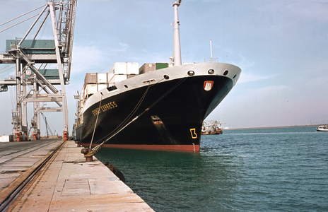
Hapag-Lloyd ship in the port of Fos-sur-Mer

.JPG)

The Canal de Donzère-Mondragon is a side canal of the Rhone on a section south of Montélimar and north of Avignon. Side canals of the Great Rhone in the Camargue are the Canal d'Arles à Fos , the Canal du Rhône à Fos and the Canal Saint-Louis , which connect Arles with Fos-sur-Mer and the Mediterranean.
The Rhone is connected to other waterways such as rivers and canals: In the north there is a connection from Lyon via the Saône and the Rhine-Rhône Canal (River Doubs ) to eastern France and the Rhine . In the south there is a connection to the Canal du Rhône à Sète . An important connection for freight traffic from the Golfe de Fos (Canal du Rhône à Fos) to the Étang de Berre is via the Canal de Caronte . The Canal de Marseille au Rhône connected the Étang de Berre with Marseille until the tunnel du Rove collapsed .
Various canal projects in the Alps that would have connected the Rhone and Lake Geneva with the Upper Rhine , such as the Trans-Helvetic Canal, remained unrealized .
Streets
Important road connections in the Rhone Valley were and are:
- the Roman Via Agrippa , which led upstream from Arelate (today's Arles ) to Lugdunum (today's Lyon ) on the left of the Rhone ,
- the route nationale 7 (N7), which partly follows the Via Agrippa. In the period after the Second World War until the construction of the A7, the N7 was France's holiday route from the greater Paris area to the Mediterranean,
- the route nationale 86 (N86) on the right of the Rhone , which served to relieve the N7,
- the Autoroute A7 , which has taken over the task of the N7.

Roman roads in Gaul, Via Agrippa in the Rhone Valley.
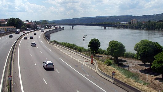
Autoroute A7 on the left bank of the Rhone near Valence , with the Pont Frédéric Mistral


railroad
The oldest railway line on the Rhone is the Saint-Étienne – Lyon railway , 20 km along the river and then 35 km from Givors to the coal town of Saint-Étienne , with the first steam traction (from 1831) on the European continent.
Various railway lines run along the Rhone. The railway accompanies the Rhone virtually along its entire length. This already begins in Gletsch, where the meter-gauge Furka-Oberalp Railway emerges from the old Furka Tunnel (the Furka Base Tunnel extends to Unterwassern ), which connects Visp in the Valais with the Rhaetian Railway in the Vorderrheintal and with Göschenen on the Reuss . Today it is operated by the Matterhorn Gotthard Railway between Oberwald and Visp . The Simplon route runs from Brig to Lausanne along the Rhone and the north bank of Lake Geneva. In St. Maurice, the Saint-Gingolph – Saint-Maurice railway branches off from it , laid out in 1859 as part of the first railway line in Valais from Lake Geneva to Sion . The route on the north bank often runs at a certain height above the bank on the slope. The Lausanne train station is around 75 meters above sea level. From Geneva, the Lyon – Genève railway follows the Rhone. From Lyon up to the height of Avignon there is a double-lane railway line on both banks, the one on the western bank is now practically only used for freight traffic. It continues below Avignon, turned away from the Rhone, to Nîmes , where it reunites with the Tarascon route . The line on the eastern bank of the Rhone was the main connection between Paris and Marseille until the TGV high-speed lines were built . This leads from Avignon via Tarascon to Arles further along the Rhone. From Arles, the Rhone no longer has an accompanying railway line, as both the Chemin de Fer de la Camargue line , a narrow-gauge line of which led to Salin-de-Giraud , and the line to Saint-Louis are now closed and broken off.
The LGV Rhône-Alpes high-speed line for TGV trains has been connecting Lyon with Valence since 1994. In 2001, the LGV Méditerranée route was opened, which leads from Valence via Avignon to Marseille - since then, in connection with the LGV Sud-Est route, the travel time between Paris and Marseille has only been three hours.

LGV / TGV network with a route between Lyon and Avignon along the Rhone.
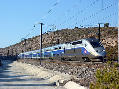
A TGV duplex on the LGV Méditerranée.

.jpg)
The Rhone in art
Vincent van Gogh spent part of his life in Arles in the nineteenth century and immortalized a. a. the Rhone in paintings.

Starry Night over the Rhone , oil painting by Vincent van Gogh

Langlois Bridge on the Canal d'Arles à Bouc , oil painting by Vincent van Gogh


At the end of the twentieth century, the Swiss writer Pierre Imhasly set a monument to the Rhone in his poem and life's work Rhone Saga in twelve years of literary work.
Economy in the Rhone Valley
Agriculture
The Swiss part of the Rhone is used for agriculture, but especially the French Rhone Valley (Vallée du Rhône), downstream of Lyon, which is an important agricultural region in France thanks to the warm climate. Many types of fruit are cultivated in the climatically favorable Rhone Valley, B. peaches , cherries , apricots and strawberries .
In the Rhone valley between Vienne and Avignon you will find the Rhône wine-growing region , especially the Côtes du Rhône (slopes of the Rhone) - there you will find the famous Châteauneuf-du-Pape wine region . Viticulture in the southern Rhône valley has already been proven for pre-Roman antiquity; wine-growing began here in France, starting from Phoenician and Greek trading establishments. But the Rhone Valley with the Valais and the slopes of Lake Geneva is also important for viticulture in Switzerland .

The Rhône wine-growing regions
Viticulture at the Hermitage

Viticulture in Châteauneuf-du-Pape


Nuclear energy
The Électricité de France (EDF) operates several nuclear power plants on the Rhone . The location on the Rhone was chosen because the water of the river is available for cooling. In addition to facilities for the production of electrical energy, there are also various nuclear facilities for civil and military processing of nuclear material and for research on the Rhone. This means that a significant part of the French nuclear industry is located on the Rhone.

Locations of nuclear power plants and nuclear facilities on the Rhone (order downstream):
- Creys-Malville nuclear power plant (“Superphénix”, Isère département , east of Lyon ) in 1997 finally shut down
- Bugey nuclear power plant ( Département Ain , east of Lyon) two pressurized water reactors
- Saint-Alban nuclear power plant (Isère department, south of Lyon) two pressurized water reactors
- Cruas nuclear power plant ( Ardèche department , near Montélimar ) four pressurized water reactors
- Tricastin nuclear power plant ( Département Drôme , south of Montélimar) - four pressurized water reactors (the Eurodif uranium enrichment plant is also located on the site )
- Marcoule nuclear plant ( Languedoc-Roussillon , north of Avignon ) - the site includes the decommissioned Marcoule nuclear power plant , the decommissioned prototype reactor Phénix , decommissioned facilities for the vitrification of nuclear waste and facilities for the reprocessing of fuel elements and for the production of MOX fuel elements .
research
The CERN , the European Organization for Nuclear Research, located in the valley of the Rhone near Geneva. The largest facility at CERN is the Large Hadron Collider (LHC), a particle accelerator in an underground ring tunnel with a circumference of 26.7 kilometers. The LHC is largely located on French territory and partly on Swiss territory.
See also
- List of rivers in France , two parts: list of the most important by length and alphabetical list of all.
- List of French Mediterranean tributaries, sorted geographically
Web links
- Jean-François Bergier: Rhone. In: Historical Lexicon of Switzerland .
- Rhone on the ETHorama platform
- Voies navigables de France (VNF) , operator of the Rhone canal (French)
- Ticinoin photo: Rhone Glacier on www.flickr.com
Individual evidence
- ↑ Geoserver of the Swiss Federal Administration ( information )
- ↑ Swisstopo - the measurement function gives the same value as the card entry
- ↑ a b c d Jean-François Bergier: Rhone. In: Historical Lexicon of Switzerland .
- ↑ Aux Ripes Chancy measuring station 1935–2016 (PDF) Federal Office for the Environment FOEN
- ↑ (Station: V7200010 , option: Synthèse )
- ↑ Le Rhône at SANDRE (French)
- ↑ https://www.openstreetmap.org/?mlat=43.338037&mlon=4.825657&zoom=12#map=14/46.1666/5.9898
- ↑ Larousse: Camargue - Région de Provence (Bouches-du-Rhône), comprise entre les deux bras principaux du delta du Rhône.
- ↑ geoportail calls the lower course "l'Aygues" in the Cartes IGN classiques and Carte topographique IGN versions, but "l'Aigue" in the Carte IGN and Carte France raster
- ↑ Bourbre according to management association 750 km²
- ↑ Contrat de milieu Bassin versant du Bourget du lac
- ↑ LEMANIQUES: Article of the Revue de l'Association pour la Sauvegardde du Léman from 1994 as PDF from 2016 , 3rd page, info box La Venoge et ses Affluents
- ^ 3e correction du Rhône project website of the canton of Valais, accessed on March 7, 2018.
- ↑ La 3e Correction du Rhône avance à un rythme soutenu on vs.ch, accessed on March 7, 2018.
- ↑ Rhone correction: billion-euro loan approved. In: schweizerbauer.ch . September 10, 2019, accessed September 10, 2019 .
- ^ Jules-Bernard Bertrand: Du Rhône alpestre et de la navigation fluviale dans le passé. En marge des fêtes du Rhône de 1934. In: Annales valaisannes , 1934, pp. 237–249.
- ↑ Rud. Schätti: New shipping equipment for the Rhone. In: Schweizerische Bauzeitung. Volume 62, Issue 7, August 16, 1913, pp. 85ff. doi: 10.5169 / seals-30763
- ↑ Last exit: summer. In: zeit.de. July 27, 2006, accessed February 7, 2016 .
Rivers with a total length of more than 30 km:
Aare |
Albula |
Allaine |
Old Rhine |
Arbogne |
Areuse |
Swiss stone pine |
Birs |
Brenno |
Broye |
Calancasca |
Doubs |
Drance de Bagnes |
Thinning |
Emme |
Engelberger Aa |
Ergolz |
Glâne |
Smooth |
Glenner (Glogn) |
Hinterrhein |
Inn (En) |
Julia (Gelgia) |
Kander |
Little Emme |
Landquart |
Land water |
Langete |
Limmat |
Linth |
Lorze |
Maggia |
Mentue |
Moësa |
Muota |
Murg |
Necker |
Orbe |
Petite Glâne |
Plessur |
Rabiusa |
Reuss |
Rhine |
Rhone |
Saane |
Schüss (Suze) |
Seez |
Scythe |
Sihl |
Simme |
Sitter |
Sorne |
Suhre |
Talent |
Tamina |
Ticino (Ticino) |
Thur |
Töss |
Venoge |
Verzasca |
Vispa |
Vorderrhein |
Wigger |
Wyna