Véore
| Véore | ||
|
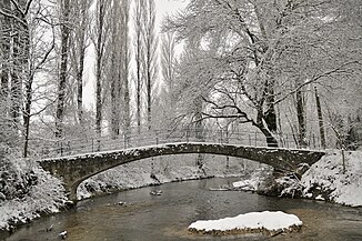
Bridge over the river at Beaumont-lès-Valence |
||
| Data | ||
| Water code | FR : V40-0400 | |
| location | France , Auvergne-Rhône-Alpes region | |
| River system | Rhône | |
| Drain over | Rhône → Mediterranean | |
| source | in the municipality of La Baume-Cornillane, 44 ° 49 ′ 55 ″ N , 5 ° 4 ′ 35 ″ E |
|
| Source height | approx. 835 m | |
| muzzle | on the municipal boundary of Étoile-sur-Rhône and Livron-sur-Drôme in the Rhône Coordinates: 44 ° 48 ′ 37 ″ N , 4 ° 49 ′ 15 ″ E, 44 ° 48 ′ 37 ″ N , 4 ° 49 ′ 15 ″ E |
|
| Mouth height | approx. 94 m | |
| Height difference | approx. 741 m | |
| Bottom slope | approx. 20 ‰ | |
| length | 38 km | |
| Left tributaries | Petit Véore, Écoutay , Pétouchin | |
| Right tributaries | Guimand | |
| Small towns | Chabeuil | |
The Véore is a river in France that runs in the Drôme department in the Auvergne-Rhône-Alpes region . It rises in the municipality of La Baume-Cornillane , drains in the upper reaches in a northerly direction, stretches through the Vercors Regional Nature Park , then swings to the southwest and after a total of 38 kilometers flows into the municipal boundary of Étoile-sur-Rhône and Livron-sur-Drôme as left tributary into the Rhône .
Places on the river
Attractions
- Pont sur la Véore , 17th century bridge over the Véore - Monument historique
See also
Individual evidence
- ↑ Source geoportail.fr (1: 32,000)
- ↑ estuary geoportail.fr (1: 16,000)
- ↑ a b The information on the length of the river is based on the information about the Véore at SANDRE (French), accessed on June 23, 2012, rounded to full kilometers.
- ↑ Pont sur la Véore in the Base Mérimée of the French Ministry of Culture (French)
