Drôme department
| Drôme | |
|---|---|
| region | Auvergne-Rhône-Alpes |
| prefecture | Valence |
| Sub-prefecture (s) |
The Nyons |
| Residents | 511,553 (Jan. 1, 2017) |
| Population density | 78 inhabitants per km² |
| surface | 6,530.56 km² |
| Arrondissements | 3 |
| Community associations | 16 |
| Cantons | 19th |
| Communities | 364 |
|
President of the Department Council |
Didier Guillaume ( PS ) |
| ISO-3166-2 code | FR-26 |
 Location of the Drôme in the region Auvergne Rhône-Alpes |
|
The Drôme [ dʀoːm ] is the French department with the atomic number 26. It is in the southeast of the country in the region Auvergne Rhône-Alpes and was named after the river Drôme named, a tributary of the Rhone .
geography

The Drôme department is located in south-eastern France, in the Dauphiné region , and has an area of 6530 km². This makes it one of the medium-sized departments. The highest point is the Rocher Rond at 2,453 meters , another well-known peak is the Roc de Garnesier ( 2,388 m). The lowest point is at 50 meters above sea level, at the point where the Rhône leaves the department to the south.
The area of the Département Drôme can be divided into three natural landscapes: the hilly area between the rivers Rhône and Isère in the north of the department, the valley of the Rhone ( vallée du Rhône ), which extends from north to south over the entire area of the Drôme, and a section of the French Alps in the east of the department. These include the Vercors , Dévoluy , Diois and Baronnies mountains .
The Drôme department borders on the Ardèche , Isère , Hautes-Alpes , Alpes-de-Haute-Provence and Vaucluse departments .
In the south of the department lies the canton of Valréas , which belongs to the Vaucluse department and thus forms an enclave within the Drôme department.
coat of arms
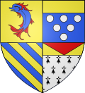
Description : In the golden shield forward above rotbeflosster jumping Blue Dolphin front bottom four blue oblique bar , the back up in blue six (3; 2; 1) silver balls under a golden shield main and rear black bottom ermine on silver, about a golden bar with red overturned tip .
history
The area of the Département Drôme was occupied in antiquity by the Celtic tribe of the Allobroger , their settlements were mainly on the banks of the Isère . Other small Gallic (Celtic) tribes also populated the area.
As a province of the Roman Empire , the country experienced an economic boom. Numerous settlements emerged in the fertile valleys in what is now the Drôme department. These people lived mainly from agriculture. The cities of Saint-Paul-Trois-Châteaux ( Augusta Tricastinorum ), Die ( Colonia Dea Augusta Vocontiorum ) and Valence ( Julia Valencia ) developed in industry and were able to sell their goods to the Romans.
During the 11th, 12th and 13th centuries, many wars were fought in this area between the bishops, counts and other nobles. Finally Frederick I ceded the land to the Bishop of Valence .
Before 1789, the area was largely part of the Dauphiné with a few Provencal enclaves. The department was formed on March 4, 1790.
From 1960 to 2015 it was part of the Rhône-Alpes region , which in 2016 became part of the Auvergne-Rhône-Alpes region.
Administrative division
| Arrondissement | Cantons | Communities | Residents January 1, 2017 |
Area km² |
Density of population / km² |
Code INSEE |
|---|---|---|---|---|---|---|
| The | 5 | 112 | 67,697 | 2,498.70 | 27 | 261 |
| Nyons | 6th | 149 | 149.036 | 2,478.78 | 60 | 262 |
| Valence | 12 | 103 | 294,820 | 1,553.08 | 190 | 263 |
| Drôme department | 19th | 364 | 511,553 | 6,530.56 | 78 | 26th |
With effect from February 1, 2006, the cantons Dieulefit, Marsanne, Montélimar-1 and Montélimar-2 moved from the Arrondissement of Valence to the Arrondissement of Nyons as part of an administrative reform.
See also:
- List of communes in the Drôme department
- List of cantons in the Drôme department
- List of associations of municipalities in the Drôme department
Web links
- General Council of the Drôme Department (French)
- Prefecture of the Drôme Department (French)
Individual evidence
- ^ Assemblée ( Memento of November 28, 2012 in the Internet Archive ) accessed on August 31, 2012.
Coordinates: 44 ° 54 ' N , 5 ° 1' E


