Department of Ille-et-Vilaine
| Ille-et-Vilaine | |
|---|---|
| region | Brittany |
| prefecture | Rennes |
| Sub-prefecture (s) |
Fougères Redon Saint-Malo |
| Residents | 1,060,199 (Jan. 1, 2017) |
| Population density | 156 inhabitants per km² |
| surface | 6,775.39 km² |
| Arrondissements | 4th |
| Community associations | 18th |
| Cantons | 27 |
| Communities | 333 |
|
President of the Department Council |
Jean-Luc Chenut |
| ISO-3166-2 code | FR-35 |
 Location of the department of Ille-et-Vilaine in the region of Brittany |
|
The department Ille-et-Vilaine [ ileviˈlɛn ] ( Breton Il-ha-Gwilen ) is the French department with the order number 35. It is located in the northwest of the country in the region of Brittany and is after the rivers Ille (Breton: Il ) and Vilaine (Breton: Gwilen ) named.
geography
Ille-et-Vilaine is the easternmost department in Brittany.
coat of arms
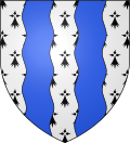
Description : Two blue corrugated stakes in an ermine .
history
The department was formed at the time of the French Revolution on March 4, 1790 on the basis of the law of December 22, 1789 on the division of France into departments from the north-eastern part of the old province of Brittany .
In the summer of 1940 it was occupied by troops of the Wehrmacht , like all of northern France , after they had won the western campaign within a few weeks and occupied Paris. In the summer of 1944, Allied troops liberated the area: after landing in Normandy , they broke out of their bridgehead and began the battle for Brittany on August 1, 1944 .
Cities
The most populous municipalities in the Ille-et-Vilaine department are:
| city | Population (2017) |
Arrondissement |
|---|---|---|
| Rennes | 216,815 | Rennes |
| Saint Malo | 46.097 | Saint Malo |
| Fougères | 20,418 | Fougères-Vitré |
| Bruz | 18,266 | Rennes |
| Vitré | 18,037 | Fougères-Vitré |
| Cesson-Sévigné | 17,526 | Rennes |
| Saint-Jacques-de-la-Lande | 13,087 | |
| Pacé | 11,739 | |
| Betton | 11,735 | |
| Chantepie | 10,435 |
Other important places are Dinard , Dinan , Dol-de-Bretagne and Redon .
Administrative division
The Ille-et-Vilaine department is divided into 4 arrondissements , 27 cantons and 333 communes :
| Arrondissement | Cantons | Communities | Residents January 1, 2017 |
Area km² |
Density of population / km² |
Code INSEE |
|---|---|---|---|---|---|---|
| Fougères-Vitré | 7th | 106 | 184,699 | 2,173.32 | 85 | 351 |
| Redon | 3 | 50 | 102,871 | 1,302.57 | 79 | 352 |
| Rennes | 17th | 109 | 605.914 | 2,228.08 | 272 | 353 |
| Saint Malo | 5 | 68 | 166,715 | 1,071.42 | 156 | 354 |
| Department of Ille-et-Vilaine | 27 | 333 | 1,060,199 | 6,775.39 | 156 | 35 |
See also:
- List of communes in the Ille-et-Vilaine department
- List of cantons in the Ille-et-Vilaine department
- List of associations of municipalities in the Ille-et-Vilaine department
climate
|
Average monthly temperatures and rainfall for Pointe de Grouin near Cancale at an altitude of 46 meters
Source: Jean-Noël Darde: Plages et côtes de France. Éditions Balland, Paris 1991
|
|||||||||||||||||||||||||||||||||||||||||||||||||||||||||||||||||||||||||||||||||||||||||||||||||||||||||||||||||||||||||||||||||||||||||||||||||||||||||||||||||||||||||||||||||||||||||||||||||||||||||||||||||||||||||||||||||
Days per year with
- Rainfalls over 1 mm: 121
- Frost: 13
- First frost: December 10th
- Last frost: February 17th
- Snow: 5
- Thunderstorm: 10
- Hail: 6
As of 1991
Web links
- Department of Ille-et-Vilaine (French)
- Prefecture of the department of Ille-et-Vilaine (French)
Individual evidence
- ↑ haben-et-vilaine.fr accessed on April 26, 2015.
Coordinates: 48 ° 8 ′ N , 1 ° 42 ′ W


