Sarthe department
| Sarthe | |
|---|---|
| region | Pays de la Loire |
| prefecture | Le Mans |
| Sub-prefecture (s) |
La Flèche Mamers |
| Residents | 566,506 (Jan. 1, 2017) |
| Population density | 91 inhabitants per km² |
| surface | 6,206.24 km² |
| Arrondissements | 3 |
| Community associations | 17th |
| Cantons | 21st |
| Communities | 354 |
|
President of the Department Council |
Dominique Le Mèner |
| ISO-3166-2 code | FR-72 |
 Location of the department of Sarthe in the region Pays de la Loire |
|
The Département de la Sarthe [ saʀt ] is French department with the atomic number 72. It is in the northwest of the country in the Region Pays de la Loire and is named after the River Sarthe named. The river and the department are namesake for the Circuit de la Sarthe , on which the 24-hour race of Le Mans is held.
geography
The Sarthe department borders on the Orne , Eure-et-Loir , Loir-et-Cher , Indre-et-Loire , Maine-et-Loire and Mayenne departments .
The most important river is the eponymous Sarthe .
history
The department was formed on March 4, 1790 from the eastern part of Maine and some northeastern tracts of Anjou .
It has belonged to the Pays de la Loire region since 1960 .
coat of arms
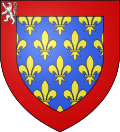
Description: six rows of golden lilies sown on a blue background , the red border is adorned with a silver lion in the upper right corner
Symbolism: The coat of arms of today's Sarthe department is that of the former county of Maine .
Cities
The most populous municipalities in the Sarthe department are:
| city | Population (2017) |
Arrondissement |
|---|---|---|
| Le Mans | 142,946 | Le Mans |
| La Flèche | 14,956 | La Flèche |
| Sablé-sur-Sarthe | 12,220 | La Flèche |
| Allonnes | 11,098 | Le Mans |
| La Ferté-Bernard | 8,820 | Mamers |
| Coulaines | 7,423 | Le Mans |
| Changé | 6,519 | Le Mans |
| Montval-sur-Loir | 6.124 | La Flèche |
| Mamers | 5,299 | Mamers |
| Mulsanne | 5,238 | Le Mans |
Administrative division
The Département Sarthe is divided into 3 arrondissements , 21 cantons and 354 communes :
| Arrondissement | Cantons | Communities | Residents January 1, 2017 |
Area km² |
Density of population / km² |
Code INSEE |
|---|---|---|---|---|---|---|
| La Flèche | 6th | 118 | 151.118 | 2,521.36 | 60 | 721 |
| Le Mans | 10 | 45 | 263,333 | 779.71 | 338 | 723 |
| Mamers | 7th | 191 | 152.055 | 2,905.17 | 52 | 722 |
| Sarthe department | 21st | 354 | 566.506 | 6,206.24 | 91 | 72 |
See also:
- List of communes in the Sarthe department
- List of cantons in the Sarthe department
- List of associations of municipalities in the Sarthe department
The Allée couverte du Colombier is located northwest of Aubigné-Racan, near the D78 road to Sarcé, in the Sarthe department.
The Dolmen la Pierre couverte (Duneau) is located directly on the "Route de Planche" road, east of Connerré, south of Duneau 30 km east of Le Mans.
Web links
- Département Sarthe (French)
- Prefecture of the Sarthe department (French)
Individual evidence
Coordinates: 48 ° 1 ′ N , 0 ° 13 ′ E


