Territoire de Belfort
| Territoire de Belfort | |
|---|---|
| region | Bourgogne-Franche-Comté |
| prefecture | Belfort |
| Sub-prefecture (s) | no |
| Residents | 142,622 (Jan. 1, 2017) |
| Population density | 234 inhabitants per km² |
| surface | 609.52 km² |
| Arrondissements | 1 |
| Community associations | 3 |
| Cantons | 9 |
| Communities | 101 |
|
President of the Department Council |
Florian Bouquet ( UMP ) |
| ISO-3166-2 code | FR-90 |
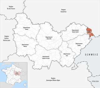
 Location of the department of Territoire de Belfort in the region Bourgogne Franche-Comté |
|
The Territoire de Belfort [ teʀiˌtwaʀdəbɛlˈfɔːʀ ] is the French department with serial number 90. It is located in the east of the country in the Bourgogne-Franche-Comté region , the capital is Belfort .
geography
The Territoire de Belfort borders in the north at the height of the Alsatian Belchen ( Ballon d'Alsace ) for a few kilometers with the Département Vosges , in the east with the Haut-Rhin department , in the south with the Swiss canton Jura , in the southwest with the Doubs department and in the west to the Haute-Saône department .
coat of arms
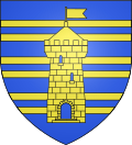
Description: Three golden twin threads in blue , above which a golden crenellated tower with an open gate and blue-illuminated windows lies.
history
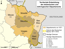
The area of the department was until 1871 the southwestern part of the Haut-Rhin . When it had to be ceded to the German Empire as part of Alsace-Lorraine in 1871 as a result of the Treaty of Frankfurt , which ended the Franco-Prussian War , the Territoire de Belfort remained with France. This happened primarily for reasons of foreign policy. In contrast to the Prussian military, Otto von Bismarck wanted a boundary that was essentially based on the language border. This course along the language border should increase international acceptance of the new demarcation and counteract French requests for revision. In the case of Belfort, Bismarck was able to prevail, in return he accepted the geographically motivated demand of the Prussian military for the annexation of French-speaking parts of northern Lorraine (area around Metz ).
The course of the new German-French state border in southern Alsace was essentially based on the German-French language border . The only deviation of the language border from the state border was represented by three localities in the vicinity of the town of Montreux-Vieux ( Altmünsterol ). This border advantage resulted from the course of the railway line and the location of the border station Altmünsterol. The French department that emerged from the separated southern part of the Sundgau was given the name Territoire de Belfort . It exclusively comprised French-speaking places.
The Territoire de Belfort initially had a special status in France with an administrateur , who was between a prefect and a sub-prefect , and a commission , whose members (commissaires) were elected according to the rules for the general councils.
After the division of Haut-Rhin in 1919, the Territoire de Belfort was not reunited with it. In 1922, the official title of the representative of the state was changed from administrateur du territoire de Belfort to préfet du territoire de Belfort - still with the lower-case generic name territoire - which is the only official act confirming the existence of the Territoire de Belfort. In 1941 it received the number 90 in the Code officiel geographique out of alphabetical order.
Today the Territoire de Belfort is considered the regular department of France. The majority of residents now feel more of Franche-Comté than of Alsace. For centuries, the Territoire de Belfort was part of the Sundgau , a relatively large and closed rulership complex between Belfort and Basel, which came from Austria to France in 1648. The borderline between the Burgundian region and the Alsatian-Alemannic region had repeatedly shuttled back and forth over the past centuries, not only in the area of the Burgundian Gate, but above all in today's Switzerland.
From 1960 to 2015 the département was part of the Franche-Comté region , which became part of the Bourgogne-Franche-Comté region on January 1, 2016 .
Cities
The most populous municipalities of the Territoire de Belfort are:
| city | Population (2017) |
Arrondissement |
|---|---|---|
| Belfort | 47,656 | Belfort |
| Dent | 5,690 | Belfort |
| Valdoie | 5,300 | Belfort |
| Beaucourt | 5,007 | Belfort |
Administrative division
The Territoire de Belfort department is divided into 1 arrondissement , 9 cantons and 101 communes .
| Arrondissement | Cantons | Communities | Residents January 1, 2017 |
Area km² |
Density of population / km² |
Code INSEE |
|---|---|---|---|---|---|---|
| Belfort | 9 | 101 | 142,622 | 609.52 | 234 | 901 |
| Territoire de Belfort department | 9 | 101 | 142,622 | 609.52 | 234 | 90 |
See also:
- List of communes in the Territoire de Belfort department
- List of cantons in the Territoire de Belfort department
- List of associations of municipalities in the Territoire de Belfort department
Web links
- Territoire de Belfort (French)
- Prefecture of the Territoire de Belfort (French)
Individual evidence
- ↑ Archived copy ( Memento of the original from May 16, 2015 in the Internet Archive ) Info: The archive link was inserted automatically and has not yet been checked. Please check the original and archive link according to the instructions and then remove this notice. accessed on May 1, 2015.
- ↑ Hans Fenske : "Everyone wants German unity ...". Bismarck and the German Question, 1848 to 1871 . Society of Friends and Patrons of the Erwin von Steinbach Foundation, Stuttgart 2015, ISBN 978-3-00-051587-3 , p. 8 ( online ).
- ^ Jean-Louis Masson: Provinces, départements, régions: l'organization administrative de la France d'hier à demain. Paris: Lanore, 1984, pp. 384-387. - ISBN 2-85157-003-X
- ↑ Gérard Lang: Le Code officiel geographique. (PDF; 1.9 MB) In: Courrier des statistiques 108 (2003), pp. 53–62, here p. 55
[4] Rudolf Michna, Persistance territoriale et identité: le Territoire de Belfort. In: Bull. De liaison des membres de la Société de Géographie, Volume 186, 2014, No. 26, p. 51-55.
Coordinates: 47 ° 38 ' N , 6 ° 52' E


